Categories
Run Reports

Venturing Higher

Back at the end of the summer when things were looking more promising, I signed up for Run the Line which is an annual race in the Dublin Mountains to raise funds for Dublin Wicklow Mountain Rescue.

Sunrise over Glencullen

Several of my friends have done this race over the years and it was always one I wanted to do so when I knew one of them was giving it another go I threw my hat into the ring for the short (13km) course. Of course my ego objected at the time saying if I’m paying money to do an event I may as well do the full course (26km) but with several niggles at me most this year, sense prevailed, I stuck with the short course and anyway I wasn’t paying money to do an event, I was contributing to a very worthy cause who not only provide an essential life saving service but also host the event in the first place.

Above the fog near Fairy Castle

Alas, so it was to be, a few days after I signed up for the event, due to be in late November, Kildare went back into lockdown, something it never really got back out of yet as it went from level 3 to level 5 and back to level 3, all requiring that I stick in Co. Kildare. It wasn’t long before the actual event was changed to a virtual event where you could do either the long course or the short course in your own locality.

Carton House: Our Virtual Venue

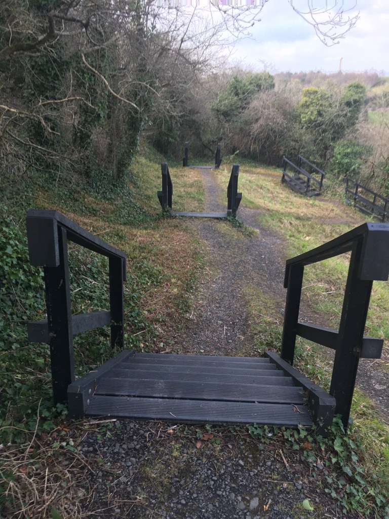
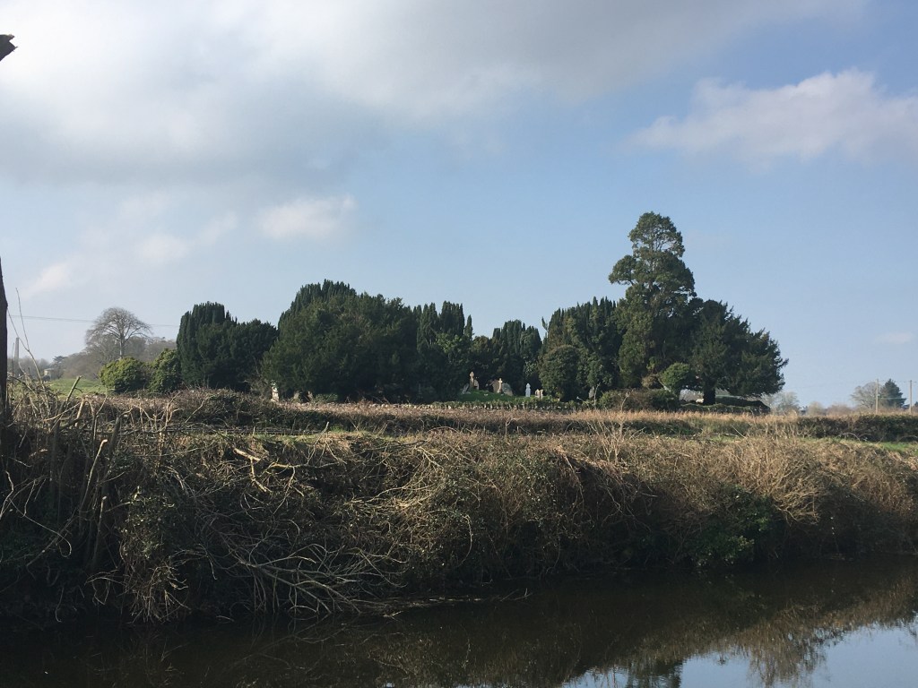
So on the weekend that the event was due to be held, myself and an intrepid Leixlip man (yet another one) decided that we would do our virtual run in the grounds of Carton House which has several mucky trails. We might not get the hills but at least we would get the muck! All the better too after I went and bought my first ever decent pair of trail runners before the event went virtual so there was no way I was going to let them stay clean.

My new Inov-8 Talons getting their first outing

Now lets remember that this website is about a canal based runner and canals being what they are, they were built on the flattest possible level between two points. That is to say that while I have delusions of grandeur of me scaling the Leadville 100, I am not a hill runner. The small climbs within the walls of Carton Demesne were enough to make me breathless.

Looking down towards Maynooth from Tyrconnell Tower

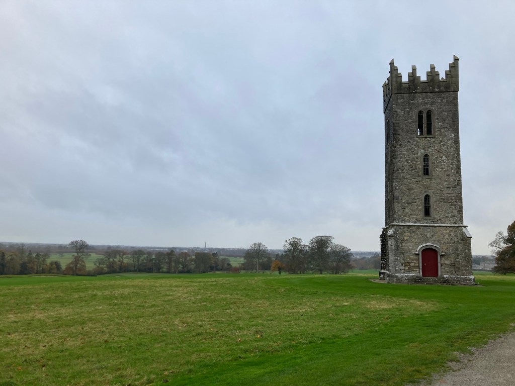
In the end I had completed a 13km run down Carton Avenue, sticking to the inside of the perimeter wall, through the forest, around the lake, up to Tyrconnell (Prospect) Tower, past the back of Carton House and returning along the wall to the finish. Run done, muddy trails traversed, hot chocolate in hand, I submitted my virtual time to the website, waited for my t-shirt to be posted out and thought no more of it.

Forest Trail in Carton

A few weeks pass, the level 5 restrictions are lifted and I get a text from the intrepid Leixlip man suggesting that we should now go do the actual route, you know, so we could truly say we earned our t-shirts. He already had done the route so had an idea of it (more or less) and if we went off course he had the gpx file on his watch. Sure why not, what else would you be doing on a Sunday morning in December.

A frosty Sunday morning across the mountains

We set off from Leixlip at 7:30 for Johnnie Fox’s Pub, the highest pub in Ireland (may be disputed by Kerry natives) not far from the Run the Line start line. As my companion and navigator ignored his cars GPS and drove on towards Bray with his mind on Glendalough I might have felt we were getting our navigation problems out of the way early but sure isn’t that the fun of it. It wasn’t long before we turned around and were on the road to Glencullen. As we ascended above Kilternan the roads were icy and needed caution, we weren’t at sea level any more. Not long after we slid into the car park of the pub, donned our trail runners and were ready to Run the Line.

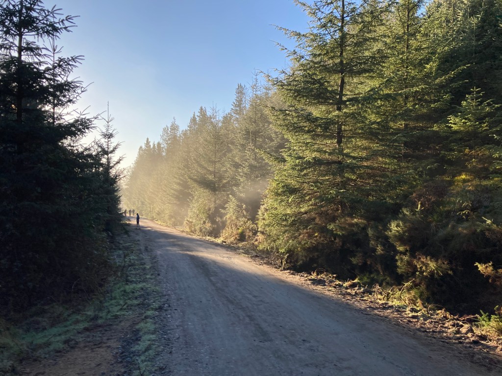
Run the Line starts on the grounds of Glencullen Adventure Park (The GAP), an amazing bike trail facility that I am tempted (though not sure I would be confident enough) to try at some point in the future. In his excitement to get going my companion pulled up the gpx route on his watch but forgot to start it. Off we went. As well cleared the Adventure Park buildings we entered the forest. Having done the course before, my navigator was sure we went through a section of this forest so not long after we reached it we are running through the trees, jumping over roots and branches, generally enjoying the freedom that we have so long sought in 2020. It was one of those moments when you actually had to stop and marvel at your surroundings.

Catching the sun between the trees

It was around the time that I stopped to take the above photo that I realised we had more or less turned 180 degrees on ourselves. Moments later we emerged about 50 meters away from where we first entered the forest. Even with a gpx file, it seems neither of us could be trusted on an unmarked course. It soon became apparent that half the forest had been cut down in the year since the last event and the route we were to take was no longer through the forest but rather alongside it. It didn’t take long to get back on course and head steadily upwards towards Fairy Castle.

A singular moment of me leading the charge skyward

Back on open ground we could see we were now above the fog below with blue skies above. It was still early enough that not many were out. We only encountered two others on our way up to Fairy Castle. It was at this early point that reality hit that I was glad I had not signed up for the 26km route. As I said previously I train mostly on the flat and while I have done a few hilly road marathons like the nearby Lap of the Gap, I was in uncharted territory. I know for Irish Mountain Runners Association (IMRA) runners this is a bread and butter route but my lungs were working hard. I had to keep FKT podcaster Buzz Burrell‘s favourite phrase of ‘perpetual forward motion’ in my mind, the idea that thru-hikers often out pace ultra-runners on long distance simply by never stopping. Of course then my mind would circle around to the fact that this was a 13km hill run just beyond Dublin city limits and not in the Rockies above Boulder, Colorado.

Perfect morning for it

We crossed over the bog land to Fairy Castle were there were a good number of people gathered enjoying the fresh morning, most likely having come up from the Ticknock side of the climb. Rightfully so my companion didn’t want to stick around a crowded place and proceeded to run on as I briefly stopped to take a picture of such poor quality I won’t even share it here. I then took off in hot pursuit on the trail path down hill. Soon enough both of us were taking advantage of the descent, brimming with over-confidence I leaped and jumped happily wishing every other walker and runner a good morning on my way by. The route was clear enough that I even ventured out in front for a while. Eventually we came to a fire road that split in various directions and I halted to seek guidance. Of course I missed the most obvious path, not because it was wide or well trodden, but rather because it went straight up.

This image does not do justice to the climb ahead with my navigator ahead beckoning me forward.

I can’t lie, I was moving at a snails pace for a while here and don’t know if I would have been able to move any faster had I indeed been racing the route. All I do know is that I was having a lot of fun and this is definitely something I want to do more of. Of course with every climb comes a down hill and soon we were on to the most technical descent of the day. How people were cycling up it was beyond me. Even on the down hill as we approached the radio masts we had a clear view across south Dublin and the stacks at Ringsend, part of my running clubs logo in Dublin Bay Running Club.

View over south Dublin

Looking at my watch we still had some 3km to go and I know that my running buddy had previously completed the course in less time than we were out now so I was more determined to keep moving at as quick a shuffle as I could, albeit stopping to take the occasional photo. My navigator had now gotten used to how the map worked on his watch so less time was spent making sure we were on the right track. The small mercy I had, despite his ability to leave me behind, was I was the one with the key to the car. We descended down another fire road which lead us back to the forest where we started.

Winter sun lighting up half the fire road

Pace quickened as we descended back down alongside the Mountain Bike trails back to the adventure park. Finally I had earned the t-shirt by completing the route (with a little extra forest loop). But lets be honest, that is not what was on my mind. When we started out I was told the cafe in the GAP does an amazing burger. I knew it would be open now so I was hoping a hot chocolate could at least be secured, possibly more. What awaited me was a breakfast bap of mammoth proportions which in and of itself would be enough to guarantee my return.

Part of me thinks I need to do the 26km to justify this

I was left in no doubt that this was an experience that I will return to and I look forward to doing Run the Line in the future. Knowing the route now is also an incentive to do more hill training so I know I can give it a proper go. Many thanks to my guide, navigator and driver for the day who also put up with my slower pace. He may have taken the occasional wrong turn but sure I did the same to him on the canal… and that’s a straight line!

Categories
Royal Canal

Walking on the Royal Canal: Confey to Maynooth

Distance: 7.6km *note Confey to Louisa Bridge is currently closed as of November 2022 for 3 months for upgrade works.

In this post I am going to look at the stretch from Cope Bridge at Leixlip Confey to the slipway at Maynooth Harbour which marks the start of the Royal Canal Greenway. While the Greenway has not yet made it to Leixlip planning is at an advanced stage and hopefully work will be underway by the end of 2021.

Once again I am starting at a train station as I have done with each of the other walking segments I have done coming out of Dublin. With the railway line right by the canal there really is no excuse not to make the best of the towpath as once you have covered the distance you want there is always a train to take you back.

Towpath at Leixlip Confey

We join the canal at Cope Bridge which most people will know as Leixlip Confey. The good news is that unlike the multiple terrains we covered in the last section, most of the route from Leixlip Confey to Maynooth at least has a solid path, albeit it can be prone to puddles on really wet days.

Canal and path between Confey and Louisa Bridge

There is less than 2 kilometres between the two train stations in Leixlip along the canal, however there are quite a number of landmarks along this stretch that are worth looking out for and if you have the time, worth investigating. As you round the corner after the straight from Cope Bridge you will cross over a spillway where water flows down off the level of the canal. Just after the spillway you will see the remains of an old canals works building.

Old canal works building painted in 2018

Immediately after the small building there is an opening and a trail path with several sets of wooden steps down into Louisa Valley.

Steps down to Louisa Valley

If you follow the steps all the way down to the bottom you will be greeted with the sight of the Leixlip Waterfall. The water flows down from the level of the canal and a small stream that lies adjacent to the canal near the spillway we crossed over. From there it joins up with the Rye River.

Leixlip Waterfall

Once you come back up from the waterfall you come to the second large undertaking necessitated by the rerouting of the Royal Canal by the demands of the 2nd Duke of Leinster as we previously mentioned on our walk through the Deep Sinking. This is the Ryewater Aqueduct which was built to carry the canal over the Rye River and on towards Carton House. The descent down to see the waterfall which isn’t even at the level of the Rye River illustrates how big an undertaking this was.

Waterways Ireland Sign approaching the Aqueduct

Engineer Richard Evans who had previously worked on the Grand Canal and on the Boyne Navigation was appointed as the engineer for the Royal Canal in 1793 and remained in the post until his death in 1802. However his time in the role is not without controversy relating to financial mismanagement of the building of the canal. Richard Evans along with company surveyor John Brownrigg would have overseen the construction of the aqueduct which soars to a height of of 26 metres above the river below. The aqueduct was beset with problems and poor weather. The foundations of the aqueduct collapsed twice during construction as the mortar would not set. It ended up costing over £27,000 to finish. That all said it has now stood over the Rye River for over 200 years carrying not only the canal but a double-line railway. Unfortunately recent attempts to get a photograph of the aqueduct from the river basin have been thwarted by wet ground. Hopefully in the near future I will get down to take a decent photograph. Sadly the magnificence of many aqueducts are missed by those crossing over them.

Leixlip Spa

While I was unable to get down as far as the the river basin I did manage to get down to the Leixlip Spa which there are signs for after the aqueduct. Discovered in 1793 by navies doing ground works for the canal, the spa waters bubble at a constaant 23.8 degrees celsius. The mineral spring was diverted into a Romanesque hexagonal basin pictured above. While popular during the 19th Century the site fell into disrepair. Restoration work took place in 2010 reinstating some of the brick work and capping that had previously been worked on in the late 1970’s and early 1980’s.

Ducks at Louisa Bridge

Once we come back up from the Leixlip Spa we can see Louisa Bridge and the train station beside it. Louisa Bridge is named for Lady Louisa Connolly of Castletown House in Celbridge. Lady Louisa was the younger sister of Lady Emily Fitzgerald, Duchess of Leinster who was the mother of our much discussed 2nd Duke of Leinster. After the death of her husband, the 1st Duke of Leinster, the now Dowager Leinster moved to Frescati House in Blackrock where she lived in more comfort then the ever increasingly indebted son, the 2nd Duke who had to retain both nearby Carton House as well as Leinster House in Dublin.

Louisa Bridge looking west with the Train Station in the top left.

Passing under Louisa Bridge we emerge out alongside Le Chéile Athletics Club running track as we head towards the Leixlip Celbridge Interchange flyover at Collinstown known as Matt Goff Bridge. Matt Goff was a Kildare County footballer who won six Leinster medals as well as two All-Irelands during the 1920’s. He was part of the Kildare winning side that was the first team to raise the Sam Maguire Cup. He worked as a military police officer and later worked for CIÉ. The bridge, built in the early 2000’s links the west side of Leixlip and Intel to the M4 motorway and Celbridge on the far side of it.

Approaching Matt Goff Bridge from Louisa Bridge

With all the development work currently ongoing at the Intel Plant at Leixlip the road next to the canal was recently moved and the short section between Matt Goff Bridge and Deey Bridge and the 13th Lock was upgraded to the standard of Greenway we can expect when we travel further west.

Wide quality path after Matt Goff Bridge

Not long after passing the bridge we come across a Royal Canal mile marker. Not many of these still exist and the weather has worn this one down but I am fairly certain that this is the 12 mile marker, not from where we started at the Liffey though, but rather from Broadstone.

12 Mile Marker west of Leixlip

After quickly rising up the locks leaving Dublin, its been some 12.5 kilometre’s since we left the 12th Lock in Castleknock before we reach the haunted 13th Lock at Deey Bridge.

New Lock gates being installed at the 13th Lock – March 2021

The Lock Gates at the 13th Lock were only recently replaced in the first few months of 2021 but great footage of the Lock being restored in 1986 can be viewed on the video below from the Hayden Collection.

There seems to be some dispute over whether it was the 13th Lock of the Royal Canal or the Grand Canal that famous Irish writer and politician Arthur Griffith wrote his haunting poem The Thirteenth Lock about. I was always told that it was the Royal Canal so I am sticking to that.* There is only 8 kilometres between the 13th Lock on the Royal and the 13th Lock on the Grand and both are the 1st locks outside of Dublin on both canals so quite likely it is associated with the unlucky number. All the same the boat mooring in the photo below is taking more of a chance than I would in their place.

Barge at Deey Bridge and the 13th Lock

*Addendum: On reading Ruth Delany’s Ireland’s Inland Waterways: Celebrating 300 Years, it would appear that the haunted lock is in fact on the Grand Canal as it was said it goes through the site of a graveyard (pg. 144).

One of the name plaques on Deey Bridge

Deey Bridge is level with a little used level crossing on the railway. We remain on the north bank as we pass the lock and take to the last grass section we will encounter on the Royal Canal. This short section of grass only lasts for about 1 kilometre not even as far the next bridge.

Starting the last grass section at Deey Bridge

Just short of the harbour at Pike Bridge outside the gates of Carton House, the graveyard and remains of a church at Donaghmore can be seen on the other side of the canal.

Graveyard near Pike Bridge.

As we reach the gates of Carton House, the canal widens out for a small harbour, no doubt so the Duke of Leinster could bring his guests right to his domain. Of course Carton House is now the home of a hotel, two golf courses and an internationally renowned training camp for sports including rugby, soccer and GAA but it was ancestral seat of the Earls of Kildare and the Dukes of Leinster since the 1100’s. The main house that now stands as part of the hotel was designed by famed architect Richard Cassels (also known as Richard Castle) who also designed other famed Irish buildings such as Leinster House and Russborough House. If you are feeling flush, you could take the walk up through the golf courses to the house for some afternoon tea. Be mindful though that it is about 2 kilometres from the gates to the front door.

Carton House Gates at Pike Bridge

Just beyond the gates as we move towards Maynooth is Pike Bridge named for Mr. William Pike and not the fish that are commonly found around this part of the canal.

Pike Harbour and Pike Bridge with a Waterways Ireland maintenance boat

It is worth leaving the canal to summit the bridge as it gives a good view over the flat lands of Kildare. In the distance can be seen Connolly’s Folly. The obelisk set above a network of arches was designed by the previously mentioned Richard Cassels and was commissioned by Katherine Connolly, wife of William Connolly, speaker of the Irish Parliament who was a grand-uncle of Thomas Connolly, husband of Lady Louisa that I previously mentioned. Confused? I sure am. Every time I dig into the names of the people who originally contributed to the building of the Royal Canal I find more that links them to each other and to the elites of Irish society. The folly is now the logo for the Irish Georgian Society who worked to restore in the 1960’s. Buried beneath is a founding member of the society, Mariga Guinness, first wife of Desmond Guinness of Leixlip Castle.

The top of the Obelisk of Connolly’s Folly.

As we emerge out on the other side of Pike’s Bridge we can see the spire of St. Patrick’s College in the distance as we make our way into Maynooth. The seminary is a contemporary of the canal both being built in the area around 1795. As we get closer to the town we can see the Straffan Road Bridge built alongside the original Mullen Bridge which leads us into Maynooth Harbour by the harbour field.

Mullen Bridge looking towards the harbour.

Maynooth is a historical town with a castle, a university and many great places for food. It is also my home town so it is far to easy for me to go into detail here so I would suggest if you have made it this far, you should take some time to explore the town. A good guide to places to eat and drink can be found on the Maynooth Town Website.

Swan nesting on the island in Maynooth Harbour

We end our walk at the Maynooth Harbour slipway after travelling just under 8 kilometres from Cope Bridge at Leixlip Confey. Once again you just need to cross the footbridge to get to the train station to get back towards Dublin. Maynooth marks the end of the rail commuter zone. From here I will be hopping on my bike for the next section as we join the Royal Canal Greenway.

Part 1: North Wall to Cross Guns Bridge

Part 2: Cross Guns Bridge to Castleknock

Part 3: Castleknock to Leixlip Confey

Part 5: Maynooth to Enfield

Part 6: Enfield to Thomastown

Part 7: Thomastown to Mullingar Harbour

Part 8: Mullingar to Coolnahay

Part 9: Coolnahay to Ballynacargy Bridge

Part 10: Ballynacargy to Abbeyshrule

Part 11: Abbeyshrule to Ballybrannigan

Part 12: Ballybrannigan to the 41st Lock

Part 13: 41st Lock to Richmond Harbour

Part 14: The Lough Owel Feeder

Part 15: The Longford Branch

Annex 1: The Old Rail Trail – Mullingar to Athlone