Probably the most frequent question I get asked by those wanting to walk, run or cycle the Royal Canal is which side of the canal should I be on? As a rule of thumb I would always advise people to follow the National Famine Way Signs along the route but below is a list of the 18 crossings and the distance between them from the Sea Lock at the Liffey to the 46th Lock near the Shannon to ensure you are on the correct side to avoid dead ends, backtracking and detours.
National Famine Way Sign on the Royal Canal
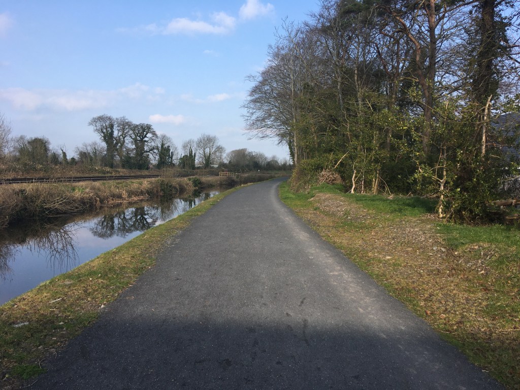
The route is certainly easier to navigate today, especially after the opening of the Royal Canal Greenway than it once was. As the route increase in popularity it is worth watching this short clip from the Hayden Collections about a group of Royal Canal Amenity Group (RCAG) members who took on to walk it in 1981.
As the canal mainly runs from east to west I will refer to being either being on the North Bank (the canal is on your left as you face west away from Dublin) and the South Bank (the canal is on your right as you face west away from Dublin). This is correct as of August 2020 when the Royal Canal Greenway has been completed from Maynooth to Cloondara and the connection from Sheriff Street to Newcomen Bridge has also opened.
The Route of the Royal Canal
Starting at the Lifting Bridges over the Sea Lock at the Convention Centre Dublin it is 2.25km to Binns Bridge and the 2nd Lock in Drumcondra on the South Bank.
Lifting Bridges over the Sea Lock at the Convention Centre Dublin
Approaching Binn’s Bridge and the 2nd Lock
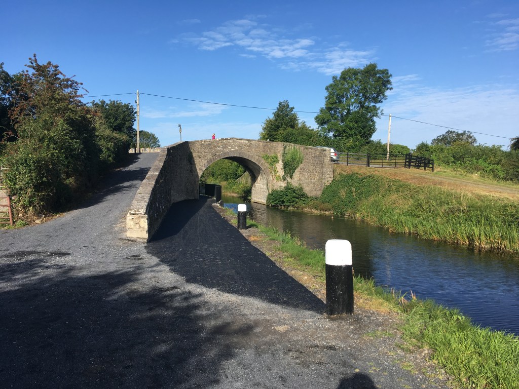
Crossing Binns Bridge at the traffic lights it is then 5.25km to Longford Bridge and the 10th Lock at Ashtown along the North Bank.
Longford Bridge at the 10th Lock, Ashtown
Crossing the new suspension footbridge beside Longford Bridge it is 5.15km to Keenan Bridge at Porterstown on the South Bank. You will know Keenan Bridge from the Memorial Plaque for the sinking of the Longford Passenger Boat which is located on the bridge after you cross it.
Keenan Bridge, Porterstown with abandoned school behind it
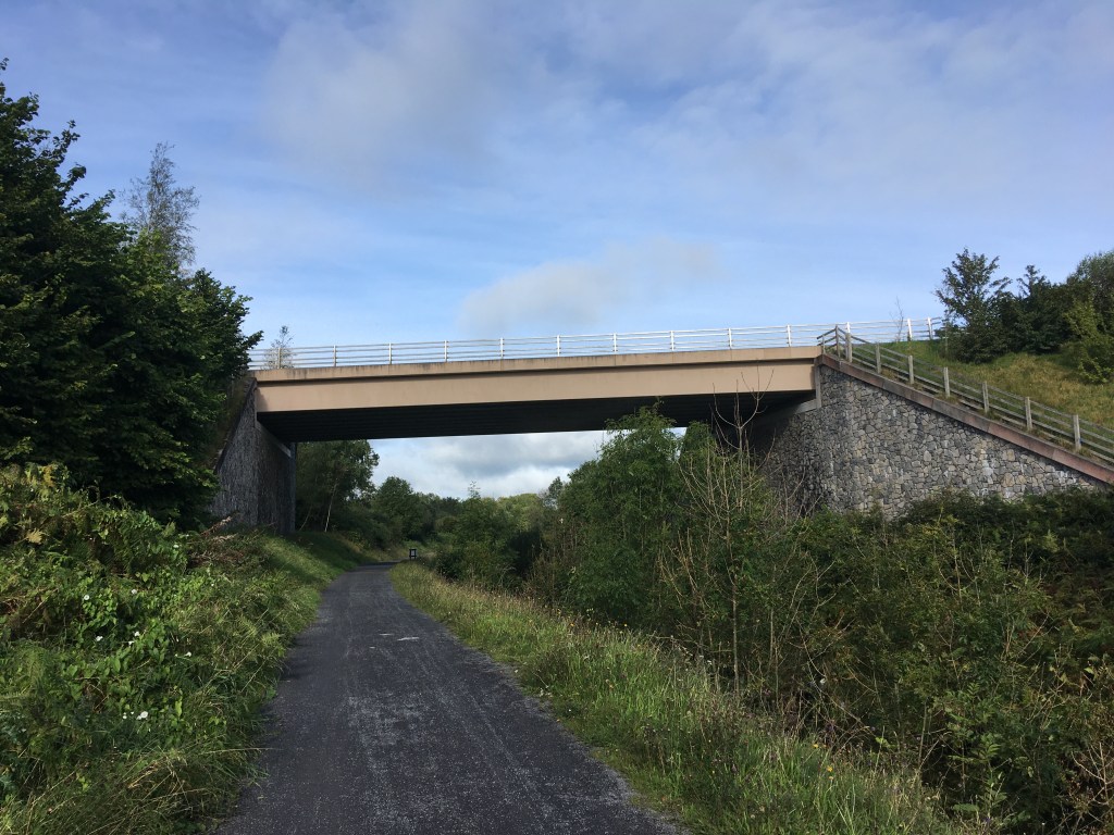
From Keenan Bridge it is a long 32.5km stretch on the North Bank before you will need to cross again at Enfield Bridge. There are a set of pedestrian lights at Enfield Bridge to help cross the road also.
Enfield Bridge with pedestrian lights visible top right
Leaving Enfield Bridge it is 6.25km to the Moyvalley Bridges on the South Bank. Here you will rise up the new long ramp and cross over the canal to Furey’s Pub.
Ramp Up to Moyvalley Bridge
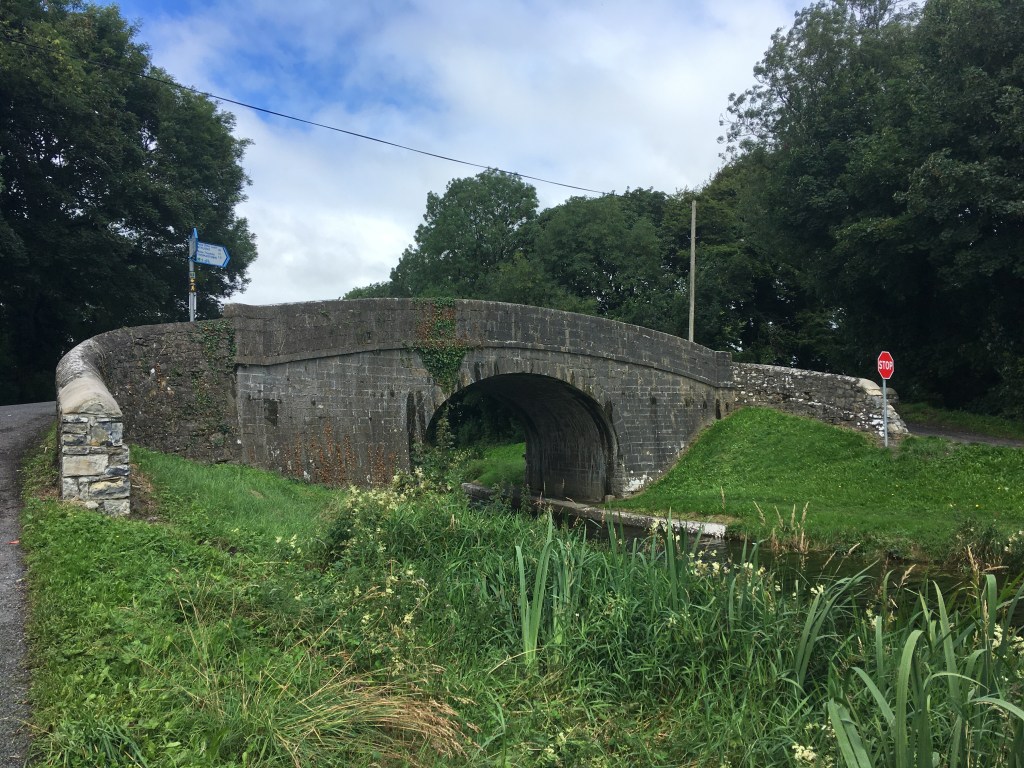
From Furey’s it is 10km to Ballasport Bridge on the North Bank.. Ballasport Bridge is in a remote location so is best to remember to cross the next bridge after the village of Hill of Down.
Crossing Ballasport Bridge it is 5.85km on the South Bank to D’Arcy’s Bridge. This is a long section for there to be no other bridges between them so all you need to remember is to cross the next bridge.
D’Arcy’s Bridge
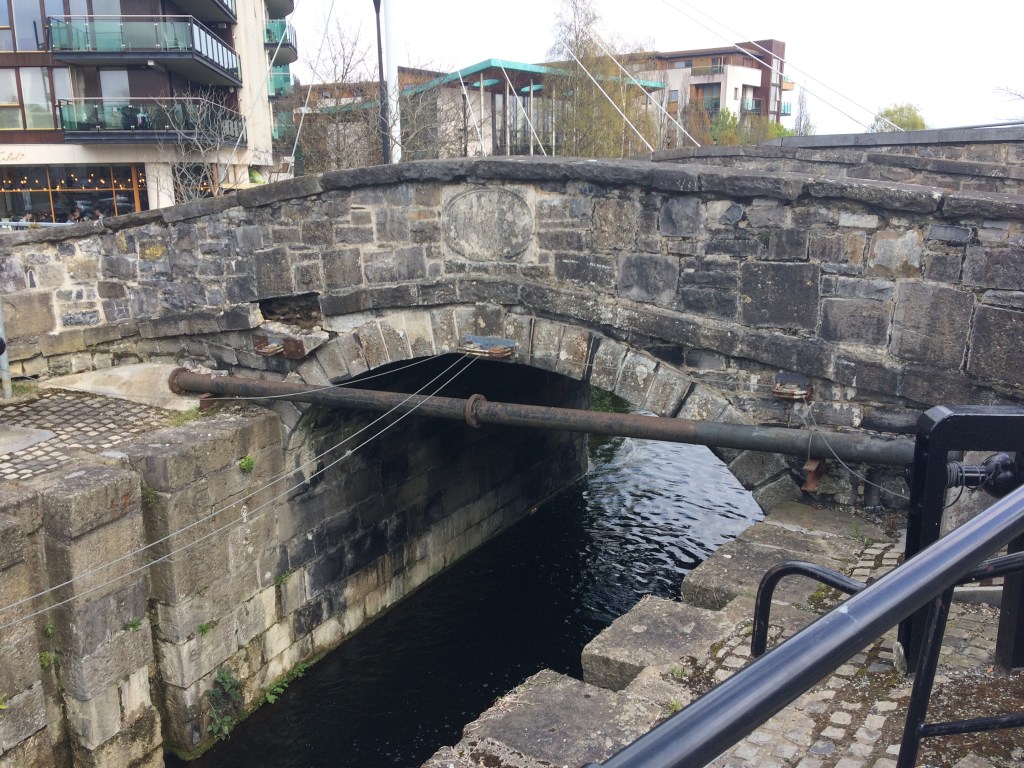
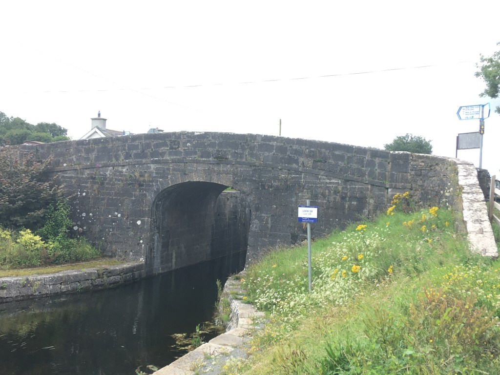
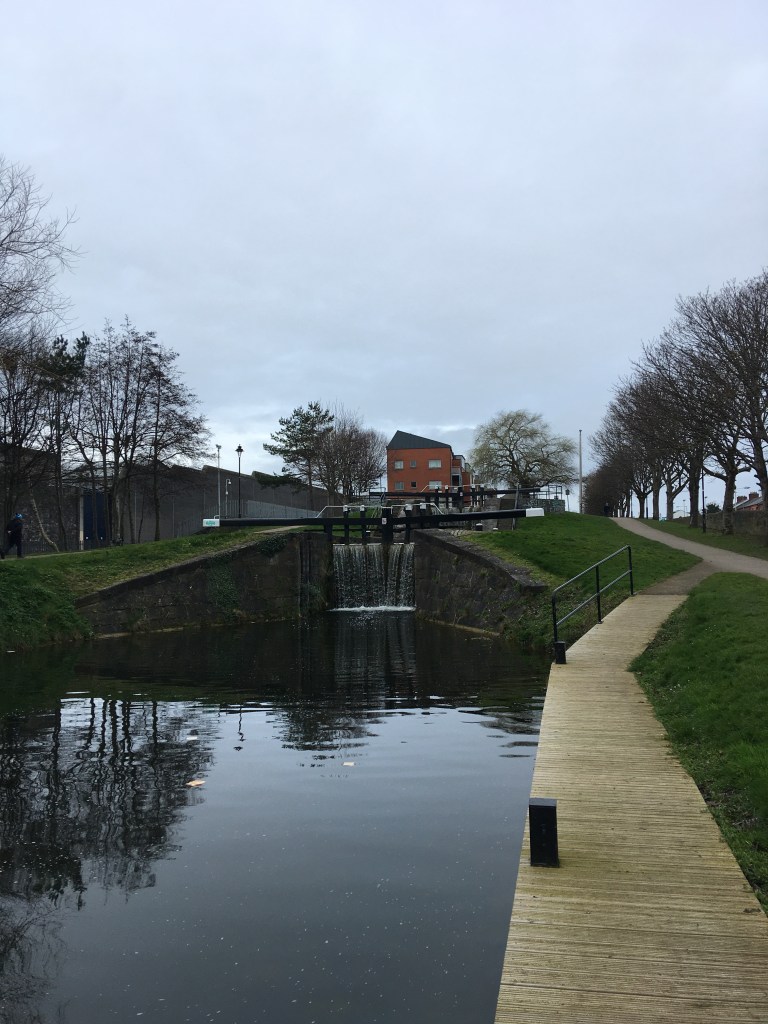
After crossing D’Arcy’s Bridge it is a short 1.3km stretch to Thomastown Bridge and the 18th Lock on the North Bank. This is also the location of Nanny Quinn’s pub.
Thomastown Bridge at the 18th Lock
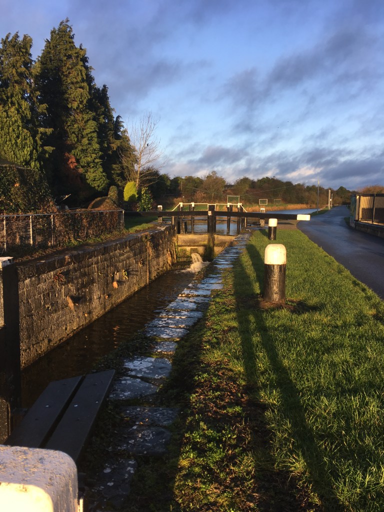
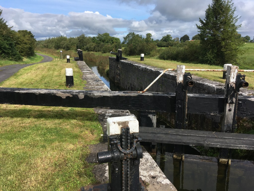
Crossing Thomastown Bridge to the South Bank we start up the flight of locks as far as Riverstown Bridge and the 22nd Lock, a distance of 1.85km. Cunningham’s Pub and shop will be signposted at Riverstown Bridge.
Riverstown Bridge at the 22nd Lock
Crossing Riverstown Bridge at the 22nd Lock we continue on up to the Summit Level on the North Bank for a distance of 3.3km before reaching McNead’s Bridge at Mary Lynch’s pub, just after we pass under the N4.
McNead’s Bridge viewed from the Mullingar side
Crossing McNead’s Bridge we have a long section of 17.2km on the South Bank, passing the whole way through Mullingar to Belmont Bridge where you will see a sharp rise up to the bridge level.
Belmont Bridge
Crossing Belmont Bridge we have the shortest single section of .65km on the North Bank as we get to Ballinea Harbour and Bridge. Coming up from the harbour car park, you can cross the original canal bridge before dropping down on the other side before the new road bridge beside it.
Continuing on the South Bank from the Ballinea Bridges we travel a distance of 15.6km as far as Kelly’s Bridge at the 38th Lock, descending all the way down from the 26th Lock at Coolnahay.
Crossing Kelly’s Bridge at the 38th Lock we travel 5.65km as far as Webb Bridge in Abbeyshrule Village on the North Bank, crossing into Co. Longford along the way. The Rustic Inn pub is located on the South Bank just before Webb Bridge.
Webb Bridge viewed from the South Bank by the Rustic Inn
After crossing Webb Bridge we have another long stretch of 18.55km along the South Bank before reaching Island Bridge at Mosstown Harbour just outside Keenagh. Island Bridge is a relatively new bridge and requires caution crossing the main road as you cross the bridge to the other side.
Island Bridge before Mosstown Harbour
From Island Bridge at Mosstown Harbour it is a short 1.45km section on the North Bank to Coolnahinch Bridge at the 41st Lock.
Coolnahinch Bridge from the 41st Lock
Crossing back to the South Bank at Coolnahinch Bridge at the 41st Lock it is 3.1km to the Ballinamore Bridges. The Ballinamore Bridges are made up of an original canal bridge and a modern road bridge. Again caution is needed crossing the main road here as you also cross the canal.
Bank on the North Bank after the Ballinamore Bridges it is 3.2km on the North Bank to Aghnaskea Bridge and the 43rd Lock, passing the Longford Branch Junction along the way.
Looking west from Aghnaskea Bridge at the 43rd Lock
Crossing Aghnaskea Bridge to the South Bank with the church it is then a final 6.5 km to the end of the Royal Canal at the 46th Lock after Richmond Harbour. Caution is needed crossing the main road at the Begnagh Lifting Bridge but you still remain on the South Bank of the canal.
Shannon Navigation Sign at the 46th and last lock of the Royal Canal
After navigating all those bridges why not watch a take a minute to look a video of all the crossing points of the Royal Canal (there are about 120 in all).
When I first started writing this blog, several parts of the Greenway were yet to be finished and the section of the canal between Sheriff Street and Newcomen Bridge was still being worked on. Thankfully now that section is open with both a path for pedestrians and a cycle-way too, I have updated this post to reflect the opening of the linear park but retain the information about the diversion up Seville Place that I took when I ran the canal.
The new linear park linking Sheriff Street to the North Strand Road along the Royal Canal.
The first section I will look at here is from the Sea Lock on North Wall Quay at the River Liffey to the 5th Lock at Cross Guns Bridge, a distance of just over 3 kilometers.
Remains of a barge in Spencer Dock
While traditionally some could argue that the Royal Canal truly starts at Broadstone or what is now the 5th Lock at Cross Guns Bridge in Phibsborough, the first Lock to be built, let us start where the Royal Canal meets the River Liffey on North Wall Quay.
Entrance to the Royal Canal under the Scherzer Lifting Bridges beside Convention Centre Dublin
With our backs to the Liffey we start on the newly completed cycle-way bridge the river side of the Scherzer Lifting Bridges. These lifting bridges, erected in the mid 1930’s were modeled on the slightly older pair at George’s Dock a little further towards the Customs House which where were installed around 1911.
Lifting Bridges alongside the newly complete footpath and cycle-way.
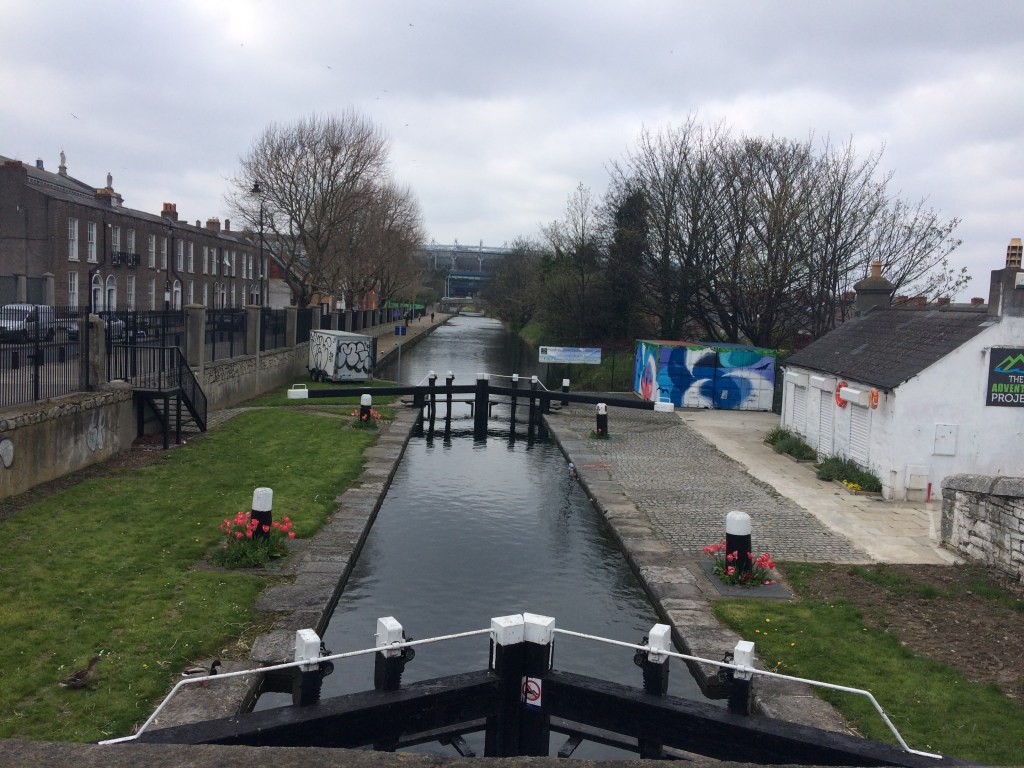
For those seeking to navigate the Royal Canal, the first sight they will see after going under these bridges is the mighty Sea Lock Gates which were installed in 2008. These new gates were designed to reduce the possibility of flooding along the canal banks between the tidal River Liffey and the 1st Lock at Newcomen Bridge.
Sea Lock Gates taken from the Lifting Bridges with Sheriff Street Lifting Bridge visible in the distance.
The first part of our walk takes us up along Guild Street on the Linear Park towards Sheriff Street. We pass over the relatively new Spencer Dock Bridge on Mayor Street which carries the Red Line Luas to the Point Village.
Spencer Dock Bridge and the Convention Centre Dublin
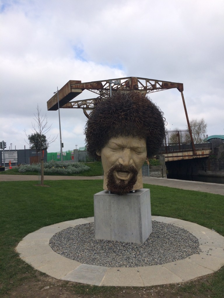
We soon come to the Luke Kelly Head Sculpture. Luke Kelly was a renowned Irish folk musician and member of The Dubliners. He grew up in the Sheriff Street area and is famed for singing The Auld Triangle, a song strongly associated with the Royal Canal. This sculpture and a statue of him on South King Street were both unveiled in early 2019 on the 35th anniversary of his death.
Luke Kelly Head Statue with the Sheriff Street Lifting Bridge behind
Behind the Luke Kelly statue we come the the Sheriff Street Lifting Bridge which is a reminder of the industrial and commercial past of the Royal Canal in this area around Spencer Dock. Of note on the now inoperable bridge are two commemorative plaques on the east side of the bridge. These plaques have the company crest of the Midlands Great Western Railway (MGWR) Company. The MGWR bought the canal in 1845 and built its railway west along the banks of the canal as far as Ballinea some 90 kilometres west of the Liffey. Both plaques predate the bridge however and were unveiled by John Poyntz Spencer, 5th Earl Spencer, Lord Lieutenant of Ireland for whom the Dock area is named.
Plaque of the MGWR Company at Sheriff Street Lifting Bridge
As mentioned at the start work is now finished on continuing the linear park and a cycle-way from Sheriff Street to the North Strand Road and opened on 31 July 2020. Before then it was necessary to divert away from the canal and head north up Seville Place as far as the Five Lamps on the North Strand Road. From here you would take a right and head back up to join the Royal Canal at Newcomen Bridge and the 1st Lock.
Looking down at the 1st Lock from Newcomen Bridge with the renovated Lock Keepers Cottage on the right now home to The Adventure Project
Thankfully it is no longer necessary to leave the bank of the Royal Canal and you can continue straight up to the Railway Bridges that span over the canal and Ossary Road. A total of 5 lines run over these bridges including the lines west to Maynooth and Sligo, the DART lines to Howth and Malahide as well as the lines onto Drogheda, Dundalk and Belfast. The first bridge was built in 1842, the second in 1903 and a later addition to the east carries a maintenance line for washing trains.
Piers of the three bridges, steel columns for the 1903 Bridge (left), cut stone for the original 1842 Bridge (middle) and concrete for the latest extension (right).
Next we come to Effin Bridge which is named so for the difficulty and inconvenience in lifting it to let boats pass. The lifting bridge which carries a railway line over the canal sits on the level of the canal and is only raised several times a year to allow boats to pass. Scheduled lift dates for 2021 have yet to be announced however work has recently taken place by Irish Rail on the bridge replacing the timber under the tracks.
Effin Lifting Bridge
A large ramp now lifts pedestrians and cyclists up from the Railway Bridges over the tracks at Effin Bridge to bring us level with Newcomen Bridge and the 1st Lock at the North Strand Road.
Newcomen Bridge and the 1st Lock
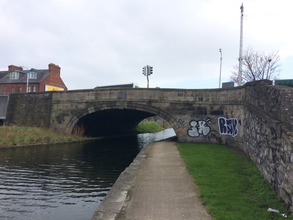
Crossing the North Strand Road and continuing on the south bank we head towards Clarke Bridge. Like with most of the bridges we will encounter as we head west, the original canal bridge would have been built between 1790 and 1810 with an abutted railway bridge added from the 1840’s as the MGWR started laying their tracks. It is also the first bridge we encounter that we can pass under with a towpath accommodated under the bridge. A noticeable feature of both Clarke Bride and Clonliffe Bridge is that it is difficult for the walker to pass under them as the arch appears much lower than other bridges. The reason for this being is that the canal level was raised between the 2nd Lock and the 1st Lock with the building of the railway to North Wall and so the path is now higher than it was when the bridge was originally built. A full explanation of this can be found on page 59 of the late Brian J. Goggin’s book The Royal Under the Railway.
Clarke Bridge with its lower head room heading towards the 1st Lock
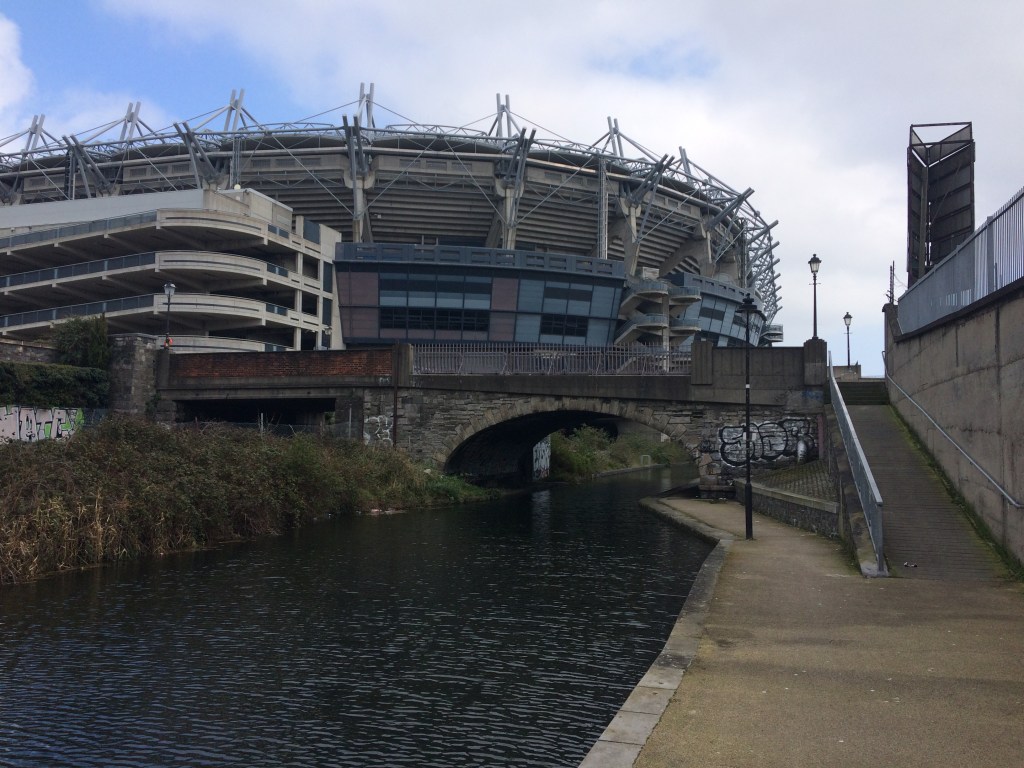
As we come out the west side of Clarke Bridge we are met with the impressive sight of Croke Park, Ireland’s biggest stadium and home of the GAA. The canal passes under what was once known as the Canal End but since 2007 has been known as the Davin Stand, named for the GAA’s first President Maurice Davin.
Croke Park and Davin Stand rising above Clonliffe Bridge looking east.
After passing under Croke Park we come to Clonliffe Bridge which carries Russel Street over the canal and the railway. It should be noted that Croke Park has a railway running either side of it. On the Canal End is the railway line to the Docklands Train Station at Sheriff Street and on the Railway End better known as Hill 16 is the railway line into Connolly Train Station.
Only 400 metres from Clonliffe Bridge we come to Binns Bridge and the 2nd Lock, a double chambered lock at Drumcondra and the first of several double chambered locks we will meet. While a large pipe attached to the bridge takes away from its original aesthetic, the double arches of the Railway Bridge make it more appeasing. As we enter the 2nd Lock we now begin a quick ascent up out of the city to the 12th Lock in Castleknock. The canal rises 12 locks in the space of 9 kilometres from the 1st Lock and of these 7 have double chambers.
Binns Bridge entering the 2nd Lock and the double arches of the Railway Bridge
It us not possible to go under Binns Bridge as so we must rise up to the road level and cross busy Dorset Street while also crossing over to the North Bank of the canal to carry on. As we reach the other side we are greeted by the statue of Brendan Behan who wrote the play The Quare Fellow which opens with a rendition of the previously mentioned The Auld Triangle. It is open to debate as to whether Brendan or his musically talented brother Dominic actually wrote the song itself.
Brendan Behan Statue with Triangles and Pigeon
The Quare Fellow is set in Mountjoy Prison which has stood beside the Royal Canal since it opened in 1850 and where Behan himself was incarcerated as an inmate. The sits beside the 2nd Lock it is not long before we reach the 3rd Lock.
Looking up the 3rd Lock
The 3rd Lock, 4th Lock and 5th Lock, all double chambered locks come in quick succession and while a person walking or running alongside the canal can make quick progress up this stretch, it takes considerably longer to navigate.
Below the 4th Lock
The 4th level of the canal is also the location where the original Broadstone Branch of the Royal Canal came out but has long since been filled in with a linear park running down alongside the prison wall.
Where the Broadstone Branch would have joined the Main Line
The Broadstone Branch is a topic I intend to return to in a different post and will link here when I do. Where the prison car park now stands was once a dry dock for the maintenance and repair of boats.
Cross Guns Bridge originally known as Westmoreland Bridge, the location of the first bridge to be built on the Royal Canal
Before we reach the 5th Lock we must rise up again to meet the Phibsborough Road at Cross Guns Bridge. Originally known as Westmoreland Bridge after the 10th Earl of Westmoreland, Lord Lieutenant of Ireland, who laid the first stone of the original bridge in 1790. The bridge was replaced in the 1860s to help facilitate the building of the short railway tunnel beside it. A video celebrating the 10th Anniversary of the reopening of the canal to navigation can be seen here:
In total we have traveled a little over 3 kilometres from the Liffey so far not including our diversion down Seville Place but here is a good place to stop for a drink or a bit of food at the recently relocated Bernard Shaw pub and EatYard.
One of the great things about walking along the Royal Canal in the Dublin area is that you are never too far from a train station so its always easy to get a train to your starting point or get a train home.
In my last walking post, I left you having a pint and a burger at The Bernard Shaw by Cross Guns Bridge and the 5th Lock after the short walk from town. This morning I will have to catch back up with you as I got the train from Maynooth to Drumcondra and had to walk the short distance from the Brendan Behan Statue back up to Cross Guns Bridge.
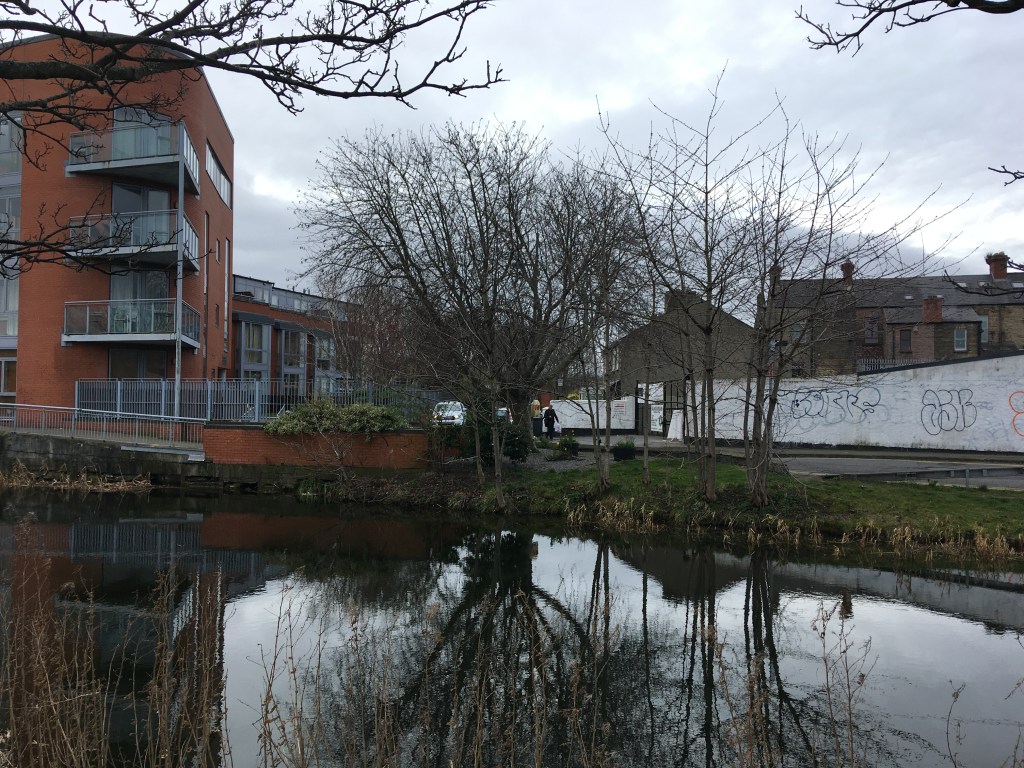
Today I start at the 5th Lock. The 5th Lock has a small harbour above it and once even boasted a railway siding. On its south bank lies the former North City Flour Mills which has been renovated and turned into apartments. Built as an iron mill in 1840 it was converted into a flour mill in the 1860’s and provided considerable employment for many years. The building is an impressive towering presence over the canal and an important reminder of the canals industrial past.
5th Lock Gates with North City Flour Mill behind it.
Once up on the 5th Level we only need to see the other end of the harbour to see the double chambered 6th Lock along with it’s recently restored Lock Keeper’s Cottage. Like the Cottage at the 1st Lock, this cottage has found a new life as a club house for a water based sports club, this time the Cabra Kayak Club. A railway bridge once carried a line from behind the cottage over the canal just below the 6th Lock to sidings beside the mill. The stone supports of the bridge remain.
Looking up the 6th Lock with the Cabra Kayak Club Clubhouse on the right and the stone support of the old bridge jutting out just in front of the lock.
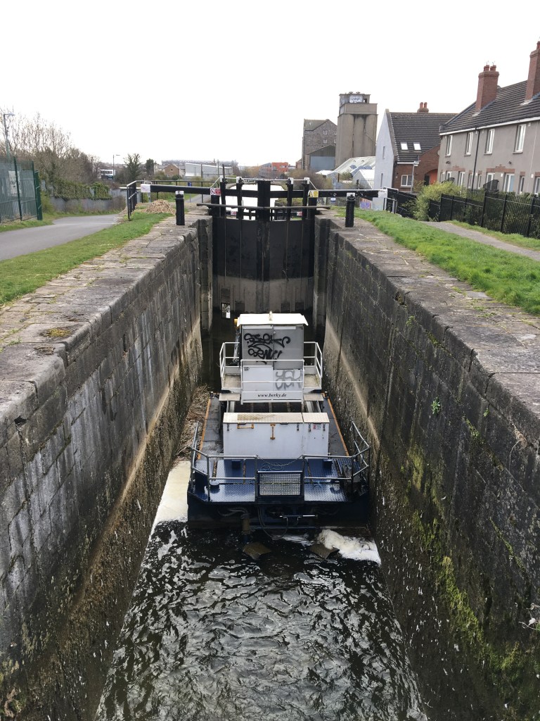
At the top of the 6th Lock we have risen up 5 double chambered locks in only 1200 metres which is quite a climb in a very short distance. As I looked back down into the upper chamber of the 6th Lock today I found a Waterways Ireland Maintenance Boat sitting in the chamber.
Waterways Ireland Maintenance Boat sitting in the 6th Lock with the Flour Mill in the background. The empty chamber gives a good view of the skilled masonry of the lock chamber as it approaches 230 years old.
We have a bit of time on the 6th Level as we walk along side the railway and the St. Paul’s Section of Prospect (Glasnevin) Cemetery. Not far in the distance we see O’Connell Round Tower on the main grounds of the cemetery. We also pass by four small cottages called the Coke Oven Cottages which most likely were built by the Midland Great Western Railway company for their workers. These four cottages enjoy a secluded feel right in the heart of Dublin
O’Connell Tower viewed in the distance from the Royal Canal
As the canal turns slightly north you would hardly notice that we pass over an aqueduct carrying the Royal Canal over the railway line that connects Irish Rails western terminus of Heuston Station with the north south bound lines at Connolly Station. This line runs through a tunnel under the Phoenix Park which was closed for many years and only reopened to passenger trains in recent years.
Looking down at the Heuston Line from the aqueduct on the 6th Level. The double arch bridge carries the Dublin-Sligo line. O’Connell Tower also in the background.
Ahead of us we can see the 7th Lock and the water tower at what used to be known as Liffey Junction but is now better known for Broombridge Railway Station and LUAS depot. The Dublin-Sligo line leaves the canal here via a railway bridge over the canal.
Looking down the 7th Lock with the railway bridge crossing over the canal and the old Liffey Junction water tower on the right.
Currently the terminus of the LUAS Green Line, Broombridge was the location where the old Midlands Great Western Railway (MGWR) line used to go in to Broadstone Station. When the LUAS line was extended from St. Stephen’s Green it was decided that the tramline would follow the route of the old railway from Broadstone to Broombridge and the area now serves as a busy inter-connector between the railway and the tram.
LUAS Depot at Broombridge
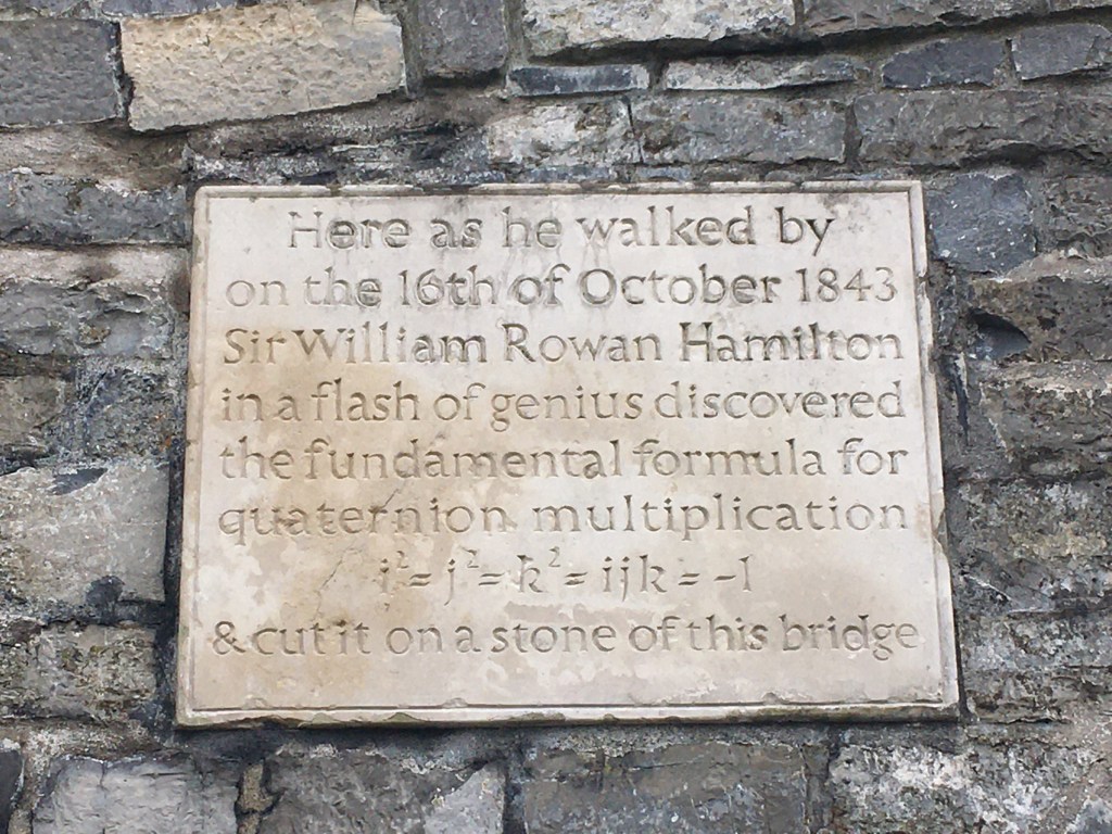
After passing Broombridge Railway Station we pass under what is now known as Hamilton Bridge named after famed mathematician and astronomer Sir William Rowan Hamilton. The bridge was originally named for William Broome, a subscriber to the Royal Canal Company and a local landowner when the canal was being built. It is now more famous for being the location where Sir William Rowan Hamilton etched the fundamental formula for quaternions into the bridge while out for a walk along the canal on the 16th of October 1843. It is believed he did this in fear he may not remember it later but in doing so set a precedent for graffiti along the canal for many years to come.
Plaque unveiled by Éamon de Valera on the 13th of November 1958 on Hamilton Bridge
In recent years Irish Rail came in for some abuse when they translated the name of Broombridge Station as Droichead na Scuab (Bridge of the Brush) and had to change it when it was pointed out that the area was named after the Broome family. Most the bridges of the Royal Canal are named for subscribers to the Royal Canal Company who contributed to the early construction of the canal. Names of all these subscribers can be found on pages 34 and 35 of Ruth Delany and Ian Bath’s Ireland’s Royal Canal: 1789-2009 which is an amazing resource if not the bible for those with an interest in the history of the Royal Canal and also of its restoration as spear-headed by the Royal Canal Amenity Group.
We pass under the green Ratoath Road Overpass bridge which carries traffic over both the canal and the railway replacing the once very congested Reilly’s Bridge at the 8th Lock. Reilly’s bridge became a bottleneck for traffic as while the bridge crossed the canal, the 8th Lock lower the water lever so that only a level crossing was needed to cross the railway.
The now closed Reilly Bridge at the 8th Lock. Royal Canal Way sign can be seen on the right. A construction yard for the new Pelletstown Railway Station can be seen on the other side.
Irish Rail started clearance work in February 2020 for a new railway station to be built at Pelletstown on the 8th Level right before the 9th Lock. Work is still ongoing as of February 2021 but a new footbridge over the canal to the new station has now been installed just east of the 9th Lock. A considerable amount of new residential buildings have sprung up around here in the last 15 years including Royal Canal Avenue and Royal Canal Park and the Rathborne area. Nestled in among this area is also the Royal Canal Kayak Club just before Ashtown.
Looking up at the 9th Lock from where Pelletstown Railway Station will be built.
As we approach the Longford Bridge and the 10th Lock we have now travelled 4.35 kilometres from Cross Guns Bridge. This might be a good time to take a quick pit stop. There is a SuperValu just off the canal at Ashtown but The Lock Keeper Canal Bar has always been a favourite place of mine to stop in for some pub grub and a pint. I am looking forward to trying out the new look when the Covid restrictions lift. Douglas and Kaldi is also another popular cafe right on the canal.
Statue of a Lock Keeper outside The Canal Bar
We have been on the north bank of the canal since we started at the 5th Lock today so now we must cross over the pedestrian bridge at Longford Bridge to carry on our journey west on the south bank. Several original canal bridges have seen recent additions of pedestrian bridges alongside them to allow the original bridge have more space for vehicular traffic. For those who want to finish up, Ashtown Train Station offers trains in both directions to Dublin and Maynooth pretty much every half hour.
10th Lock and railway gatekeeper cottage on the other side.
We are now in Fingal and if you look beyond the gatekeepers cottage you will see a 5 storey Water Mill dating from the 1820s just behind it. The 10th level has a lit smooth tarmac surfaced path the whole way to the M50 Aqueduct. A park and ride railway station now called Navan Road Parkway opened along this stretch in the late 2000’s. There is no access to this from the canal however. After the industrial feel around Tolka Valley and Broombridge and the residential feel around Rathborne the 1.5 kilometre stretch of the 10th level almost feels rural albeit with the railway running alongside us.
Lights and path of the 10th Level
We soon approach the double chambered 11th Lock with its two strange chimney like structures beside it. If anyone knows what they are I would be grateful to be informed but my best guess is that they were stopping posts for the barges from the canals trading days.
Chimney like structures at the 11th Lock
From here we can both hear and see the busy traffic of the M50 motorway and its junction with the N3. Several road bridges cross over the canal between here and the 12th Lock. In the middle of all this modern infrastructure lies Ranelagh Bridge dating from around 1810 and beyond it lies the impressive M50 Aqueduct which carries the canal over the busy motorway below. This a multi-tiered junction carrying roads, railways, canals and paths, many generations and forms of transport converging on the one spot.
M50 Aqueduct view from Ranelagh Bridge
After sailing over the M50 we emerge at Talbot Bridge (which was poorly modified for heavier traffic before becoming almost redundant with the building of the motorway) and the double chamboured 12th Lock. The 12th Lock marks the end of our 10 kilometre climb out of the city from the River Liffey and the last lock in County Dublin. In total we have climbed 65 metres and 8 double chambered locks, a feature that is a lot less prevalent as we head further west. It will be another 12.5 kilometre before we encounter the 13th Lock at Deey Bridge west of Leixlip.
Looking up the 12th Lock from Talbot Bridge with the 12th Lock Hotel on the left.
The 12th Lock and Castleknock has a small harbour which tends to have a good number of boats tied up all year round. There is nice small hotel and bar called The 12th Lock which is a nice place to stop in if you are waiting for a train at the nearby Castleknock Train Station. To get to the train station you can continue past the canal boats in the harbour towards Granard Bridge.
Looking back at barges by the 12th Lock from Granard Bridge.
Once the far side of Granard Bridge we have reached our end point for the day at Castleknock Train Station after travelling just over 7 kilometres from our start at Cross Guns Bridge or just over 10 kilometres if you started at the city centre.
Waiting for the train home at Castleknock Train Station
Part 3 of our journey sees us start at Castleknock Train Station and the start of the stretch known as the Deep Sinking, on past Coolmine and Clonsilla before crossing the Dublin and Kildare county line and finishing at Cope Bridge at Leixlip Confey.
Turning to Trail as we enter the Deep Sinking
There are several reasons why I have chosen to do my first few posts as walks rather than runs or cycles. The first being that in the early stages leaving Dublin there are so many prominent landmarks, bridges and locks all worthy of mention that the posts would be extremely long if I was covering a greater distance. The second was for when I reached the Deep Sinking and what lies beyond it to Leixlip Confey and even on to Maynooth.
Narrowing of the Trail in the Deep Sinking
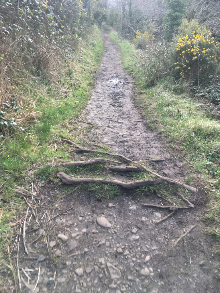
Many who know the area know that unlike from the city centre to Castleknock which has all paths or from west of Maynooth Harbour where the Royal Canal Greenway is complete all the way to Cloondara, the section between Castleknock and Maynooth is more trail like with a variety of surfaces which can be uneven, slippy, mucky and narrow.
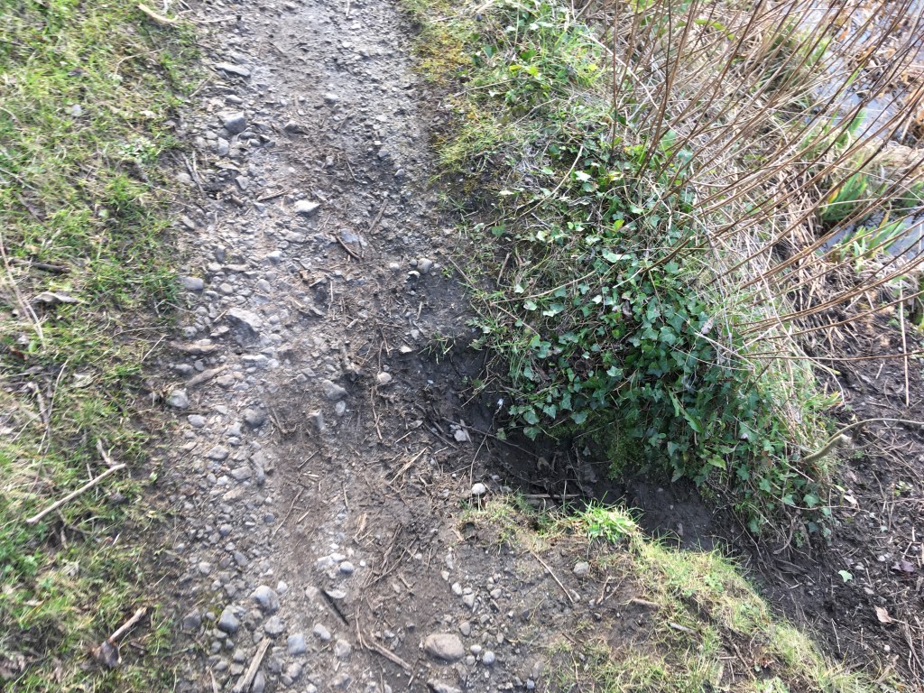
One of several gulleys to watch out for leaving Castleknock
By no means should this put you off wandering along this stretch of the canal. Given it is surrounded by houses and railway it still has a rural and secluded feel. What follows here is just a matter of fact account of how the stretch is as of March 2020 and that the reality is it is best walked at a relaxed pace, ideally in hiking boots or trail runners and being honest it is not suitable for bikes. Fingal County Council and Waterways Ireland have plans to upgrade this section and some ground surveys are ongoing (which also leads to the occasional closing of the canal path) but it is unlikely that this work is going to be completed in the near future.
Tree roots on the trail of the Deep Sinking.
I would consider the trail beside the Deep Sinking in several parts. The first part is a very short wide space which is just grass as you leave Castleknock Train Station. Not long into this though the path narrows to reflect the images above. This narrow path starts to rise up above the canal and for the most part is soft and often muddy ground with gulleys slipping down the slope and tree roots to be mindful of. This section stretches for 1.5 kilometres as far as Kirkpatrick Bridge and Coolmine Train Station.
Pedestrian Bridge obscuring Kirkpatrick Bridge at Coolmine
While the building of the Royal Canal started in 1790, the original survey to find a suitable route across north Leinster was undertaken by Thomas Williams and John Cooley as early as 1755. Their suggested route would have utilised a series of lakes and rivers along the way to the Shannon in an effort to keep construction costs down.
Deep Sinking at Coolmine
However as the story goes, William Robert Fitzgerald, the 2nd Duke of Leinster, a subscriber of the Royal Canal Company wanted the canal to pass his country residence of Carton House outside Maynooth and this necessitated the routing of the canal through a limestone quarry. A sinking is where a canal is cut through the land to maintain the same level rather than using locks to go over it. The Deep Sinking itself is a cutting through the limestone quarry which was blasted and dug through at great expense. At certain points through the Deep Sinking the towpath can rise up between 8 and 9 metres above the canal. A perilous danger for the horses pulling the barges below.
Looking down the trail from Kirkpatrick Bridge
We are unable to go under Kirkpatrick Bridge and so must rise up and cross the main road and level crossing at Coolmine Train Station before proceeding on the second section of the Deep Sinking towards Keenan Bridge. This section is not without its own treasures though, a pair of arches hide away under the trail where most would never even notice and are best seen by taking a boating trip through the Deep Sinking.
One of the hidden arches that carries the trail through the Deep Sinking
The surface on this section is similar to the previous section though there are a few more stony out crops to be mindful not to trip on. A video by Ciaran Whyte showing what it is like from Coolmine to Deey Bridge at the 13th Lock can be viewed here.
Dr. Troy Bridge over the canal and railway
Like the previously discussed Reilly’s Bridge near Broombridge, Keenan Bridge at Porterstown was often the site of long tail backs with the level crossing beside it so before we reach the bridge we pass under Dr. Troy Bridge which rises high above both the canal and railway removing the need for the level crossing.
The muddy approach to Keenan Bridge
Abandoned Gate Keepers Cottage at Keenen Bridge
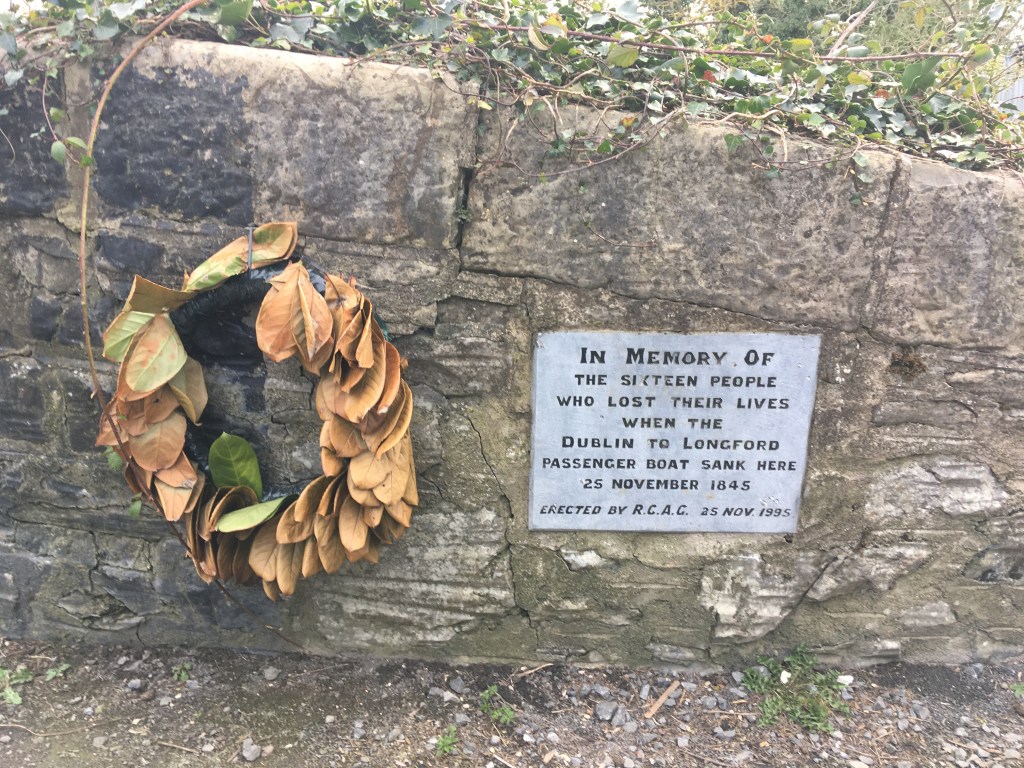
The area around Keenan’s Bridge in Porterstown could be considered one of sorrow. The first thing we see as we reach the bridge is the abandoned Gate Keepers Railway Cottage at the old level crossing. At this point we must cross over Keenan Bridge from back to the north bank of the canal to continue. As we descend back down to the canal path we see a memorial to the sinking of the Longford Passanger Boat on the other side of the bridge.
Memorial and wreath erected by the RCAG Keenan Bridge
As previously mentioned the massive drop between the towpath and the canal at the Deep Sinking was rather dangerous and 16 people lost their lives when the passenger boat Longford sank near here on the 25th of November 1845. An account of the sinking can be found on the Irish Waterways History website here.
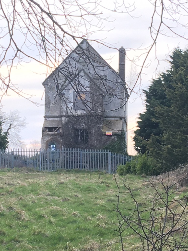
The old Porterstown National School
Before carrying on our journey west on the north bank we can see the old Porterstown National School rise high above the canal bank. This abandoned school, closed in 1963, is known by many in the area as the School of Spite as the priest who sought to build it insisted it be built to such a height so as to annoy the local landowner Baron Annaly of Luttrellstown Castle who refused to contribute to the schools construction. In 2010 the building is sadly associated with the murder of a 12 year old girl who went missing in the area giving rise to the building being fenced and secured.
Thankfully I do have some good news as we continue west, after leaving the trail path of the south bank from Castleknock we do get a compacted stone dust path from Keenan Bridge for 1.2 kilometre to Callaghan Bridge in Clonsilla.
Stone path from Keenan Bridge to Clonsilla
As we pass under Callaghan Bridge at Clonsilla we can see the Clonsilla Train Station Signal Box rising high above the canal.
Clonsilla Train Station Signal Box
You must pass under the bridge and come up on the other side to actually get to the train station. There is also an Applegreen service station only a 2 minute walk from the station if you feel the need to top up supplies.
Callaghan Bridge at Clonsilla with name plaque visible over arch
Back down on the canal you might be happy to find the next small second of path is actually tarmac. There has been a lot of discussion about whether or not we should try tarmac the entire route with many advocating that we should instead of the compacted stone dust we find for most of the route beyond Maynooth. While I agree that this would make cycling easier, especially as I own a road bike, it is not without problems.
Tarmac cracks easily from roots below it and weathers badly over time causing trip hazards and requires more frequent maintenance
After our short reprieve from the trails from Keenan Bridge to not long after Callaghan Bridge we return to brief stoney section before a grassy trail surface for most of the rest of our journey to Leixlip Confey.
Pipe over the canal and stoney path west of Clonsilla.
The railway splits just after Clonsilla Train Station with one line continuing west towards Sligo and the other being the reinstated line that crosses the canal and heads north through Dunboyne and on to the M3 Parkway park and ride station. We pass under the new railway bridge not far west of Clonsilla.
Bridge carrying railway over the canal to M3 Parkway
We are back on the grass once we reach the far side of the railway bridge as we proceed on towards Pakenham Bridge. The bridge is most likely named for Thomas Pakenham who became a Rear Admiral in the Royal Navy and later the Master General of Ordnance in Ireland. He was the youngest son of the 1st Baron of Longford.
Approaching Pakenham Bridge from the east. The building on the right is most likely a former gate keepers cottage for the railway.
After going under Pakenham Bridge we have a 1.8 kilometre stretch towards Collins Bridge with Westmanstown Golf Club and sports facilities on the opposite bank. Again this is a manageable soft grass surface which can be muddy when wet.
Collins Bridge from the east.
Passing under Collins Bridge the ground on the other side has a tendency to be very soft even when dry.
Canal towpath west of Collins Bridge
1 kilometre from Collins Bridge we leave Fingal and County Dublin and enter County Kildare, welcomed by the sign of the Royal Canal Amenity Group (RCAG) Boathouse and Slipway.
RCAG Boathouse and slipway near Confey
It is a most welcome sight to see a good number of boats currently tied up here as let us not forget that while we are enjoying our walk, cycle or run, the Royal Canal is first and foremost a navigation. Footage about the work of the RCAG from its early days in the 1970’s can be seen here:
It is only a short walk from the boathouse, past Confey GAA to Cope Bridge and Leixlip Confey Train Station and in total we have covered 8.65 kilometre through the Deep Sinking, past Coolmine and Clonsilla, leaving Dublin behind us and entering Kildare. Close to Cope Bridge there is a Supervalu at Riverforest the far side of the bridge as well as the River Forest Hotel with pub and grub.
Distance: 7.6km *note Confey to Louisa Bridge is currently closed as of November 2022 for 3 months for upgrade works.
In this post I am going to look at the stretch from Cope Bridge at Leixlip Confey to the slipway at Maynooth Harbour which marks the start of the Royal Canal Greenway. While the Greenway has not yet made it to Leixlip planning is at an advanced stage and hopefully work will be underway by the end of 2021.
Once again I am starting at a train station as I have done with each of the other walking segments I have done coming out of Dublin. With the railway line right by the canal there really is no excuse not to make the best of the towpath as once you have covered the distance you want there is always a train to take you back.
Towpath at Leixlip Confey
We join the canal at Cope Bridge which most people will know as Leixlip Confey. The good news is that unlike the multiple terrains we covered in the last section, most of the route from Leixlip Confey to Maynooth at least has a solid path, albeit it can be prone to puddles on really wet days.
Canal and path between Confey and Louisa Bridge
There is less than 2 kilometres between the two train stations in Leixlip along the canal, however there are quite a number of landmarks along this stretch that are worth looking out for and if you have the time, worth investigating. As you round the corner after the straight from Cope Bridge you will cross over a spillway where water flows down off the level of the canal. Just after the spillway you will see the remains of an old canals works building.
Old canal works building painted in 2018
Immediately after the small building there is an opening and a trail path with several sets of wooden steps down into Louisa Valley.
Steps down to Louisa Valley
If you follow the steps all the way down to the bottom you will be greeted with the sight of the Leixlip Waterfall. The water flows down from the level of the canal and a small stream that lies adjacent to the canal near the spillway we crossed over. From there it joins up with the Rye River.
Leixlip Waterfall
Once you come back up from the waterfall you come to the second large undertaking necessitated by the rerouting of the Royal Canal by the demands of the 2nd Duke of Leinster as we previously mentioned on our walk through the Deep Sinking. This is the Ryewater Aqueduct which was built to carry the canal over the Rye River and on towards Carton House. The descent down to see the waterfall which isn’t even at the level of the Rye River illustrates how big an undertaking this was.
Waterways Ireland Sign approaching the Aqueduct
Engineer Richard Evans who had previously worked on the Grand Canal and on the Boyne Navigation was appointed as the engineer for the Royal Canal in 1793 and remained in the post until his death in 1802. However his time in the role is not without controversy relating to financial mismanagement of the building of the canal. Richard Evans along with company surveyor John Brownrigg would have overseen the construction of the aqueduct which soars to a height of of 26 metres above the river below. The aqueduct was beset with problems and poor weather. The foundations of the aqueduct collapsed twice during construction as the mortar would not set. It ended up costing over £27,000 to finish. That all said it has now stood over the Rye River for over 200 years carrying not only the canal but a double-line railway. Unfortunately recent attempts to get a photograph of the aqueduct from the river basin have been thwarted by wet ground. Hopefully in the near future I will get down to take a decent photograph. Sadly the magnificence of many aqueducts are missed by those crossing over them.
Leixlip Spa
While I was unable to get down as far as the the river basin I did manage to get down to the Leixlip Spa which there are signs for after the aqueduct. Discovered in 1793 by navies doing ground works for the canal, the spa waters bubble at a constaant 23.8 degrees celsius. The mineral spring was diverted into a Romanesque hexagonal basin pictured above. While popular during the 19th Century the site fell into disrepair. Restoration work took place in 2010 reinstating some of the brick work and capping that had previously been worked on in the late 1970’s and early 1980’s.
Ducks at Louisa Bridge
Once we come back up from the Leixlip Spa we can see Louisa Bridge and the train station beside it. Louisa Bridge is named for Lady Louisa Connolly of Castletown House in Celbridge. Lady Louisa was the younger sister of Lady Emily Fitzgerald, Duchess of Leinster who was the mother of our much discussed 2nd Duke of Leinster. After the death of her husband, the 1st Duke of Leinster, the now Dowager Leinster moved to Frescati House in Blackrock where she lived in more comfort then the ever increasingly indebted son, the 2nd Duke who had to retain both nearby Carton House as well as Leinster House in Dublin.
Louisa Bridge looking west with the Train Station in the top left.
Passing under Louisa Bridge we emerge out alongside Le Chéile Athletics Club running track as we head towards the Leixlip Celbridge Interchange flyover at Collinstown known as Matt Goff Bridge. Matt Goff was a Kildare County footballer who won six Leinster medals as well as two All-Irelands during the 1920’s. He was part of the Kildare winning side that was the first team to raise the Sam Maguire Cup. He worked as a military police officer and later worked for CIÉ. The bridge, built in the early 2000’s links the west side of Leixlip and Intel to the M4 motorway and Celbridge on the far side of it.
Approaching Matt Goff Bridge from Louisa Bridge
With all the development work currently ongoing at the Intel Plant at Leixlip the road next to the canal was recently moved and the short section between Matt Goff Bridge and Deey Bridge and the 13th Lock was upgraded to the standard of Greenway we can expect when we travel further west.
Wide quality path after Matt Goff Bridge
Not long after passing the bridge we come across a Royal Canal mile marker. Not many of these still exist and the weather has worn this one down but I am fairly certain that this is the 12 mile marker, not from where we started at the Liffey though, but rather from Broadstone.
12 Mile Marker west of Leixlip
After quickly rising up the locks leaving Dublin, its been some 12.5 kilometre’s since we left the 12th Lock in Castleknock before we reach the haunted 13th Lock at Deey Bridge.
New Lock gates being installed at the 13th Lock – March 2021
The Lock Gates at the 13th Lock were only recently replaced in the first few months of 2021 but great footage of the Lock being restored in 1986 can be viewed on the video below from the Hayden Collection.
There seems to be some dispute over whether it was the 13th Lock of the Royal Canal or the Grand Canal that famous Irish writer and politician Arthur Griffith wrote his haunting poem The Thirteenth Lock about. I was always told that it was the Royal Canal so I am sticking to that.* There is only 8 kilometres between the 13th Lock on the Royal and the 13th Lock on the Grand and both are the 1st locks outside of Dublin on both canals so quite likely it is associated with the unlucky number. All the same the boat mooring in the photo below is taking more of a chance than I would in their place.
Barge at Deey Bridge and the 13th Lock
*Addendum: On reading Ruth Delany’sIreland’s Inland Waterways: Celebrating 300 Years, it would appear that the haunted lock is in fact on the Grand Canal as it was said it goes through the site of a graveyard (pg. 144).
One of the name plaques on Deey Bridge
Deey Bridge is level with a little used level crossing on the railway. We remain on the north bank as we pass the lock and take to the last grass section we will encounter on the Royal Canal. This short section of grass only lasts for about 1 kilometre not even as far the next bridge.
Starting the last grass section at Deey Bridge
Just short of the harbour at Pike Bridge outside the gates of Carton House, the graveyard and remains of a church at Donaghmore can be seen on the other side of the canal.
Graveyard near Pike Bridge.
As we reach the gates of Carton House, the canal widens out for a small harbour, no doubt so the Duke of Leinster could bring his guests right to his domain. Of course Carton House is now the home of a hotel, two golf courses and an internationally renowned training camp for sports including rugby, soccer and GAA but it was ancestral seat of the Earls of Kildare and the Dukes of Leinster since the 1100’s. The main house that now stands as part of the hotel was designed by famed architect Richard Cassels (also known as Richard Castle) who also designed other famed Irish buildings such as Leinster House and Russborough House. If you are feeling flush, you could take the walk up through the golf courses to the house for some afternoon tea. Be mindful though that it is about 2 kilometres from the gates to the front door.
Carton House Gates at Pike Bridge
Just beyond the gates as we move towards Maynooth is Pike Bridge named for Mr. William Pike and not the fish that are commonly found around this part of the canal.
Pike Harbour and Pike Bridge with a Waterways Ireland maintenance boat
It is worth leaving the canal to summit the bridge as it gives a good view over the flat lands of Kildare. In the distance can be seen Connolly’s Folly. The obelisk set above a network of arches was designed by the previously mentioned Richard Cassels and was commissioned by Katherine Connolly, wife of William Connolly, speaker of the Irish Parliament who was a grand-uncle of Thomas Connolly, husband of Lady Louisa that I previously mentioned. Confused? I sure am. Every time I dig into the names of the people who originally contributed to the building of the Royal Canal I find more that links them to each other and to the elites of Irish society. The folly is now the logo for the Irish Georgian Society who worked to restore in the 1960’s. Buried beneath is a founding member of the society, Mariga Guinness, first wife of Desmond Guinness of Leixlip Castle.
The top of the Obelisk of Connolly’s Folly.
As we emerge out on the other side of Pike’s Bridge we can see the spire of St. Patrick’s College in the distance as we make our way into Maynooth. The seminary is a contemporary of the canal both being built in the area around 1795. As we get closer to the town we can see the Straffan Road Bridge built alongside the original Mullen Bridge which leads us into Maynooth Harbour by the harbour field.
Mullen Bridge looking towards the harbour.
Maynooth is a historical town with a castle, a university and many great places for food. It is also my home town so it is far to easy for me to go into detail here so I would suggest if you have made it this far, you should take some time to explore the town. A good guide to places to eat and drink can be found on the Maynooth Town Website.
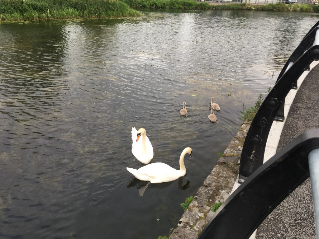
Swan nesting on the island in Maynooth Harbour
We end our walk at the Maynooth Harbour slipway after travelling just under 8 kilometres from Cope Bridge at Leixlip Confey. Once again you just need to cross the footbridge to get to the train station to get back towards Dublin. Maynooth marks the end of the rail commuter zone. From here I will be hopping on my bike for the next section as we join the Royal Canal Greenway.
After covering the last few sections on my feet, here I take to my bike to cover some more ground as we get further west into more rural landscape from Maynooth Harbour, through Kilcock and on to Enfield. Maynooth is the gateway for many to the Royal Canal Greenway, a perfect route for all adventures.
As Maynooth is often a starting or finishing point for many taking a day on the Royal Canal Greenway, it is worth noting Maynooth has a fantastic variety of places to eat and drink. Information on many of these places can be found on the Maynooth Town Website.
Maynooth Harbour just before dawn
Maynooth Harbour, located on the 13th level of the Royal Canal, is a great place to start. It is easily accessible from Dublin, with Maynooth Train Station lying on the south bank of the canal. A footbridge gives access to the north bank and the Royal Canal Greenway. Maynooth Harbour is a triangle shaped harbour with a slipway on the town side. It has an island with nesting swans in the centre. It would have been built between 1790 and 1796 making it a contemporary of the near by St. Patrick’s University which opened in 1795.
Maynooth Swans with their cygnets and the island in the background – Summer 2019
We depart Maynooth heading west on a tarmac path heading a short distance of 500 metres before we encounter Bond Bridge which was originally built in 1795. In 2005 Jons Engineering were contracted to widen and realign the bridge to make it safer for the traffic it carries over the canal. The new bridge opened in 2007 and also has cycle lanes over it with steps accessing the Royal Canal Greenway on the east side and a ramp down the west side.
Approaching Bond Bridge from Maynooth Harbour
After passing under Bond Bridge we transition from tarmac onto a smooth, light stone dust surface which will be the norm for most the way to Enfield. The South Campus wall of the university keeps us company for 750 metres as we leave Maynooth behind us. This old stone wall separates the canal bank from the playing fields and grounds of the old campus.
Pacman Graffiti on College Wall
As we reach the end of the college wall we pass the old college farmhouse and sheds. It is nearly 1 kilometre from the end of the college wall to the next landmark of Jackson’s Bridge and the 14th Lock. Jackson’s Bridge is made up of 5 spanning arches including a narrow pedestrian arch (for which cyclists should dismount), the canal, the railway and two arches for farm animals on the south bank. The original canal span was built in 1793 while the railway span was abutted in the late 1840’s.
The 5 arches of Jackson’s Bridge with the 14th Lock
We emerge on the upper 14th level after passing through the pedestrian arch with the 14th Lock revealing itself fully to view.
Water Cascading down into the 14th Lock
Leaving Jackson’s Bridge behind we proceed for 1.7 kilometres before we reach the next landmark of Bailey’s Bridge, an accommodation bridge giving the local farmer access to both sides of the canal. As part of the work to create the Royal Canal Greenway the bridge was extended to give users safe passage under the bridge rather than force them through the narrow passage that still exists.
Bailey’s Bridge with new Greenway passage
Moving on past North Kildare Club with its rugby, cricket and hockey pitches it is another 750 metres to Chamber’s Bridge and the 15th Lock. It is common to find several barges and Waterways Ireland work boats moored up at the bridge. One such barge is Anam Cara (previously Maeve) which was once used by actors Timothy West and Prunella Scales in their Channel 4 series Great Canal Journeys as they explored the Shannon-Erne Waterway. The barge was also used for the TV3 series Jingle Jangle which featured a large array of prominent Irish musicians as the barge made its way west from Dublin to Cloondara on the Royal Canal.
15th Lock from Chamber’s Bridge with Anam Cara and other barges in the background on a rather wet day.
There is another 500 metres of the light stone dust after Chamber’s Bridge before we reach another stretch of tarmac on the approach to Kilcock. As we meet the tarmac, the Royal Canal Greenway lines up and runs parallel with a road, a railway, the canal, the greenway itself, another road and the Rye River. It is 1 kilometre from the start of the tarmac surface to Kilcock Harbour.
Approaching Kilcock
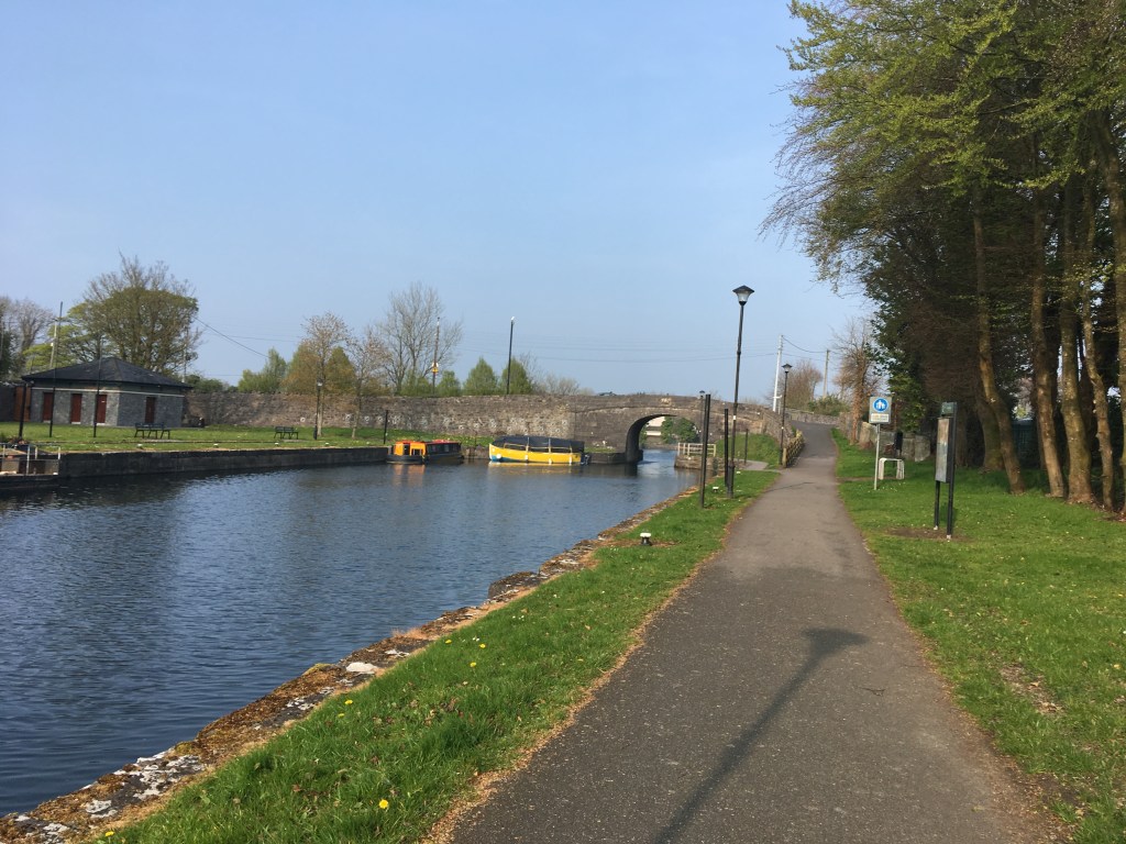
Kilcock Harbour has been wonderfully restored and is home to Kilcock Canoe Polo Club. The Royal Canal opened to commercial traffic in December 1796, six years after construction started. Barges initially started operating between Broadstone and Kilcock. At the end of Kilcock Harbour is the upgraded Shaw’s Bridge and the double-chambered 16th Lock.
Shaw’s Bridge with the 16th Lock behind it and goals from the Canoe Polo Club in the foreground.
In total it is just under 6 kilometres from Maynooth Harbour to Kilcock Harbour. As we must dismount to cross the road at Shaw’s Bridge, you may wish to stop for some refreshments before continuing on. Just across the road from the canal is the very popular Black Forest Cafe and Cakery while just a little further into the town there is a Costa Coffee as well as a large Supervalu for supplies. The Rye River Cafe is also another popular spot for breakfast or lunch not far off the canal.
Upper chamber of the 16th Lock
After coming up onto the 16th level there is a small blue container. This marks the start of the Royal Canal parkrun, Kilcock which is a weekly, free 5k run that goes out west and comes back on the banks of the canal.
The tarmac continues from the 16th Lock for just over 1 kilometre as far as Allen Bridge which is known locally as Spins Bridge. Allen Bridge was originally built in 1796 but like Bond Bridge and Shaw’s Bridge, it was later modified for modern traffic. However when you pass under the bridge you can still see the original arch.
Original arch visible under Allen (Spins) Bridge
On coming out on the other side of Allen Bridge we return to the light stone dust surface. A new spillway has been completed not far west of the bridge which replaced a narrow wooden bridge over a dip of the old slipway.
The original overflow with wooden bridge before being replaced
As we continue west for 2.75 kilometres towards McLoughlin’s Bridge and the 17th Lock (which is locally known as Ferns Lock) we cross the county border from Kildare to Meath. The Royal Canal crosses back and forth across this county line several times as the canal makes its way west.
Looking up the double-chambered 17th (Ferns) Lock from McLoughlin’s Bridge
Ferns Lock has several features around it. The bridge coming into the lock no longer has an arch and now has a low concrete plinth which has been known to catch the top of wheelhouses of boats passing under it. This happened the Heritage Boat Rambler during filming of the late Dick Warner’s Waterways – The Royal Canal series for RTÉ. It is a rare complaint on the Royal Canal that the water level is too high for such problems to happen. Unlike all the bridges we have met so far, McLoughlin’s Bridge has no abutment to a railway bridge and instead is level with a level crossing at the bridge. The 17th Lock is the last double-chambered lock on the Royal Canal coming from Dublin and marks the start of The Long Level which is a 32 kilometer stretch before the 18th Lock at Thomastown. There is also a restored storehouse beside the lock, now a private residence.
Restored storehouse and store at Ferns Lock
Leaving Ferns Lock we remain on the north bank on one of the most recently completed sections of the Royal Canal Greenway. Until late in the summer of 2019 it was necessary to travel the 5.9 kilometre section from Ferns Lock to Cloncurry Bridge on the south bank. This is a grassy and often muddy trail generally unsuitable for cycling. Thankfully the north bank is now complete and is a pleasurable cycle. The new section does veer a little away from the canal at a few points but never too far to see and it includes a section where the path winds through a forest.
Royal Canal Greenway going through the forest as seen from the south bank
One of the few disadvantages of travelling on the smooth north bank now is that you miss the original 22 and 23 Mile Markers for the canal, 2 of the very few ones left standing. These measure the distance not from the River Liffey but rather from Broadstone.
The 23rd Mile Marker on the south bank near Cloncurry
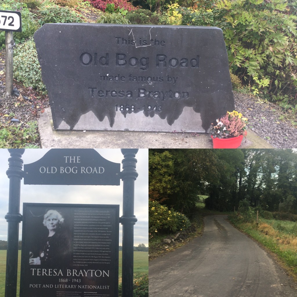
Not long after the forest, we pass a farm house which leads us back onto a tarmac surface for the last 2 kilometers to Cloncurry Bridge. The area around Cloncurry is probably best known from the poem The Old Bog Roadby Teresa Brayton, an Irish Nationalist from Kilcock who emigrated to America in 1895.
The Old Bog Road and Teresa Brayton information sign
She wrote widely on the themes of exile, nostalgic loss of homeland, nationalism and religion. She returned to Ireland in 1932 where she lived in nearby Kilbrook until her death in 1943. The Old Bog Road was put to music by Madeline King O’Farrelly from Rochfortbridge in Westmeath and has been recorded by many artists.
Cloncurry Bridge looking west
Remaining on the north bank we must cross over the road at Cloncurry Bridge to continue on our way to our destination in Enfield, a distance of 3 kilometres. Some caution is needed for the first kilometer of this as it is on a public road by the canal until you pass through a pair of wooden gates back onto the dust surface of the Royal Canal Greenway.
Enfield Train Station on the south bank.
Coming into Enfield, the railway station and a variety of connected buildings originally opened by the Midlands Great Western Railway company in the late 1840’s can be seen on the opposite bank. Buildings include the Railway Station, the Station Masters House, Warehouses, a Signal Box and Water Towers. Finally we approach our destination of Enfield Bridge, 18.7 kilometres from where we started at Maynooth Harbour.
Sunrise on the Royal Canal from Enfield Bridge.
On reaching Enfield there are a variety of places to take a break. Closest to the bridge itself is the Bridgehouse pub which does pub grub. There is an Applegreen with a Subway just a little further into town for those only looking for light refreshments. A favourite of mine would be the Street Side Cafe. Like Maynooth and Kilcock, Enfield also has a Supervalu close to the canal for those looking for a supermarket. More recently The Koffee Well has opened in the centre of Enfield with a great outdoor space and bike parking. It is an ideal place to stop for a coffee and a slice of cake while out exploring the Greenway.
Enfield Bridge. Much like Allen Bridge in Kilcock the old bridge is hidden under the widened road bridge above it.
Once you are fueled again you’ll be ready for the cycle back to Maynooth or, if you are taking it easy, the intercity from Sligo stops in Enfield roughly every 2 hours and will see you back to Maynooth or Dublin Connolly. Booking with Irish Rail is advised with bike as the trains can only facilitate 2 bikes per train.
In the last post I left off as we reached Enfield Bridge by the railway station. In this post I will look at the stretch from Enfield to Thomastown Harbour, all of which lies on the Long Level of the Royal Canal. This route offers a great chance to cycle a flat good surface out to Thomastown where you can get a good lunch and a pleasant return journey to Enfield to finish where you started, ideal to pick up you car or get a train back towards Dublin. Paid parking is generally available in the railway station car park in Enfield.
Signs pointing west on the south bank of the canal at Enfield
After spending a considerable amount of time on the north bank of the canal up to now, you now swap over to the south bank at Enfield as you head west. We see a good re-purposing of old railway tracks as they provide a barrier between the path and the incline down towards the canal until they level off with each other. On the other side of the bank you will see the stepped landscaping and tree planting that was done in the approach to Enfield Harbour. This work was undertaken by the Enfield Branch of the Royal Canal Amenity Group along with the Enfield Community Council.
Enfield Harbour as seen from the south bank.
The harbour area includes a car park, picnic area, mooring and slipway facilities as well as toilets and showers accessible by those with a Waterways Ireland access card. At the end of the harbour we pass under the R148 which was the old N4 ring road around Enfield before the M4 was built.
It is a 3.5 kilometre stretch from Enfield Bridge to the Blackwater Aqueduct. Just before we reach the aqueduct itself we can see the a solid stone chamber in the canal which can be used for stop gates to prevent the loss of water if there is ever a breach on the long level of the canal. The Blackwater Aqueduct carries the canal over the Enfield Blackwater which joins the River Boyne near Donore south of Trim and should not be confused with the Kells Blackwater which joins the River Boyne in Navan.
Blackwater Aqueduct looking west.
As previously mentioned it is hard to grasp the size of the aqueduct when you are crossing over it but unfortunately it is extremely difficult to get down to take a photo from the river. Considerable work was done to restore the aqueduct when the canal was being restored in the 1990’s and early 2000’s. The aqueduct had to be pinned together to keep it together and a good discussion about it can be seen on RTÉ’s TV series Waterways: The Royal Canal.
As we cross over the aqueduct we once again leave County Meath for County Kildare and soon we come to Kilmore Bridge. It used to be necessary to cross over the bridge and continue the journey on the north bank however recent work on the Greenway has meant that we can now pass under Kilmore Bridge and carry on west on the south bank.
Approaching Kilmore Bridge
A long fence has been put in between Kilmore Bridge and Moyvalley separating the Greenway from the railway which runs alongside it but this wide surface is a great relief from the old often overgrown trail path on the north bank.
Fence along the railway as you approach the ramp up to the old Moyvalley Bridge
As you approach Moyvalley you pass under the road bridge built in the 1970’s before rising up on a newly built ramp to the top of the original Moyvalley Bridge. Moyvalley had a train station from 1848 until 1963. When you cross over Moyvalley Bridge you are welcomed by one of my favourite watering holes on the Royal Canal, Furey’s Pub.
Furey’s Pub at Moyvalley
I find it hard to resist stopping off here any time I pass though it must be noted that they only do food Monday to Saturday so if you are passing on a Sunday, grab a pint but don’t be expecting any food. Furey’s facebook page can be found here.
Boats moored up by Furey’s at Moyvalley.
In 1807 a Canal Hotel was opened in Moyvalley and a brief description of it and it’s history as a hotel, a spa, a barracks and as an outhouse can be found here before the building was eventually demolished to make way for the new road and bridge in the 1970’s. Boats can regularly been seen tied up at Moyvalley. I noted that heritage Horse Boat 34B was tied up here the last time I passed in spring 2020.
Horse Boat 34B at RCAG Boathouse early in 2019
Carrying on west on the north bank and just before we leave County Kildare behind for the last time we come to the Ribbontail Footbridge. The bridge was built to for mass goers to cross the canal and take a mass path to the church in Longwood.
Ribbontail Bridge and stop gates
The mass path has been recently resurfaced and gives the walker or cyclist the option of going into Longwood village to pick up a few supplies.
Start of the Mass Path to Longwood
There is also a set of stop gates located at the bridge which can be closed to help stem the loss of water should there be a breach on the Long Level.
Carrying on for another 2 kilometres we come to Longwood Harbour which is home to Ribbontail Paddler’s Club. The club have canoe polo goals erected over the canal much like we saw in Kilcock and they have restored the old canal workers cottage at the harbour to use as their clubhouse. A video about the canal and the cottage can be seen here:
It should be noted that the harbour is a good bit west of the village itself and so if you want to stop there it is best to take the mass path at Ribbontail Bridge.
Longwood Harbour with Ribbontail Paddlers Club House
Immediately after the harbour we come to two aqueducts. The first is a Road Aqueduct carrying the canal over the road below. You can also see the railway bridge just a few yards over from the aqueduct. Only a stones throw from there you then cross over the Boyne Aqueduct again with the later railway bridge just a little further south. The aqueduct has 3 arches with the river passing under the middle arch.
Boyne Aqueduct facing west.
You truly get a feeling of being out in the middle of nowhere here with just the canal and the railway to keep you company. It is 2 kilometres before we reach the next landmark, Blakeshade Bridge. It is necessary to come up to the road level at the bridge and may be worth dismounting to cross before carrying on down the other side.
Blackshade Bridge
Across the canal on the south bank after Blackshade Bridge is Molerick Bog which is a designated Natural Heritage Area. It is only one of four remaining raised bogs to be found in Ireland.
Looking west from Blackshade Bridge with Molerick Bog on the left
After another 2.5 kilometres we come to the small village of Hill of Down. The village once had a train station which opened in December 1847 and closed one month shy of it’s 100th anniversary in November 1947. The village has a post office, small shop and Moran’s Pub on the south bank which can be reached by crossing over Killyon Bridge.
Moran’s Pub and Shop, Hill of Down
It is possible to carry on west under Killyon Bridge but on a bike it is best to come up onto the road and carry on down the other side, just be mindful that it is the main Trim to Kinnegad road.
Killyon Bridge, Hill of Down
Leaving Hill of Down we continue west on the north bank towards Ballasport Bridge. This section of the Greenway was built over the winter of 2016 into 2017. Ballasport Bridge carries a minor rural road over it but requires us to ascend up the bridge and cross it to the south bank to continue on our journey west. 2.5 kilometre west of Ballasport Bridge we leave County Meath behind us as we enter Westmeath.
Ballasport Bridge
The canal from here to D’Arcy’s Bridge can feel like a long stretch as you are out in open country side with only a few farmer’s houses and grazing animals along the way. Even the railway takes a leave of absence on this section as it takes a more direct route ignoring the twists and turns of the waterway. It is just under 6 kilometres between the two bridges.
D’Arcy’s Bridge near Hyde Park
D’Arcy’s Bridge is located just outside Hyde Park country house which was built not long before the canal came to this part of Westmeath. Hyde Park was the family home of the D’Arcy Family descended from Sir John D’Arcy and his second wife Joan de Burgh who was the widow of Thomas Fitzgerald, 2nd Earl of Kildare who’s descendants would go on to be the Duke’s of Leinster discussed previously.
Rope Groove’s from horse drawn boats on the edge of D’Arcy’s Bridge
We cross over D’Arcy’s Bridge to the north bank once again and if you look to the south bank you can see the remains of the last two trading boats of the Royal Canal, Floats No. 15 and 16. Both of these boats would have been horse drawn and last belonged to an independent trader by the name of James Leech. They are a good reminder of the commercial past of the Royal Canal. Rope grooves can often be found on the corners of older canal bridges where they would have been carved in over time by the horses pulling the boats.
Remains of Floats No. 15 and No. 16 near D’Arcy’s Bridge
It is just over 1 kilometre from here to our destination at Thomastown Harbour. After the sad sight of Floats No. 15 and 16 it is great to be greeted by the sight of Float No. 3 better known as the Killucan Project Barge in the harbour.
A recently repainted Killucan Project Barge in Thomastown Harbour.
The harbour has a car park on the north bank and marks the end of the Long Level which we have been on since the 17th Lock before Enfield. If we cross over Thomastown Bridge we can go over to Nanny Quinn’s Pub on the south bank.
Coming into Thomastown with Nanny Quinn’s on the south bank.
Nanny Quinn’s a great spot for a bite to eat and a drink but is often busy so it is generally best to ring ahead and make a booking if you want to have a sit down here. Nanny Quinn’s facebook page can be found here.
Nanny Quinn’s, Thomastown
From here you can either enjoy your lunch and cycle back to Enfield or if you are feeling brave you can start to climb the flight of locks towards Mullingar which is what I will do in Part 7 below..
Being honest, Thomastown is as close as you can get to being in the middle of nowhere, which is part of its charm. However unless you are able to drive here to start your day, it is an unlikely place for you to start. For me I think it is a good idea to start in Enfield and cycle to Thomastown like I discussed in Part 6, stop in Nanny Quinn’s for some lunch and then continue on towards Mullingar where you can catch a train back to Enfield. It is a distance of 42km from Enfield to Mullingar. That all said there is ample parking at Thomastown if you do have a car so for this post I am going to discuss cycling from Thomastown to Mullingar where you can stop for some food before cycling back to the start.
Ample parking at Thomastown Harbour
As mentioned in my last post Thomastown marks the end of the 32 kilometre Long Level and marks the start of a flight of 8 locks in just under 3 kilometres. It is a quick climb up to the Summit Level but means once you reach the top you have no more climbing to do and also means you have an nice descent at the end of your day if you choose to come back. We start by crossing Thomastown Bridge onto the south bank at the 18th Lock. The 18th Lock is the shortest lock on the Royal Canal at 22.9 metres long. Waterways Ireland have a depot on the north bank of the lock.
400 metres after the that we come to the 20th Lock. The National Inventory of Architectural Heritage suggests that the 42 Mile Marker is at the 20th Lock but unfortunately the survey was taken some time ago and I have never seen an sign of it. All the same it is worth keeping an eye out for.
Grooves for wooden stop boards at the 20th Lock
Continuing to climb quickly we come to the 21st Lock another 500 metres up the Greenway.
Looking across the 21st Lock to the Lock Keeper’s Cottage
It is worth noting that the section between the 18th Lock and the 22nd Lock is an open road and you should be mindful of traffic as you use the section.
22nd Lock and Riverstown Bridge
At the 22nd Lock we come to Riverstown Bridge and the road towards Killucan. The 22nd Lock also has a Lock Keeper’s Cottage on the south bank. Now a single private residence, if you look closely you can see it would originally have been two semi-detached workers cottages which makes it stand out from most the other remaining cottages along the canal.
Cottages on the 22nd Level
If you take a left at the 22nd Lock leaving the canal for a few moments you will find Cunningham’s Pub and shop just the canal side of the railway. The shop is great for a fresh ice cream and has seating outside suitable for taking a break. Their facebook page can be found here.
Cunningham’s Pub and Shop at Riverstown
Riverstown was also the site of Killucan Railway Station which closed in November 1947. A Victorian post box can still be found in the wall of the station painted An Post green.
Victorian Post Box at Riverstown Station.
The Railway Sheds in Riverstown played an important role in the restoration of the Royal Canal with a good number of new lock gates made there.
Riverstown Railway Sheds where many lock gates were made
You can read about this in Chapter 15: Under New Management of Ireland’s Royal Canal 1789-2009 where Dr. Ian Bath discusses the amount of work involved in restoring the waterway. Below is also a short video from the Hayden Collection about the Lock Gates that were manufactured in Watling Street in the early days of the Royal Canal restoration.
If you are taking the train from Dublin to Sligo you often stop at the railway sheds as it one of the few points west of Maynooth where there are double tracks allowing two trains to pass each other.
Train passing Killucan (Riverstown) Signal Box
Returning to the canal we must cross over Riverstown Bridge to the north bank to carry on to the 23rd Lock which greets us just around the corner.
23rd Lock
A further 500 metres west we come to the 24th Lock and the remains of a Lock Keeper’s Cottage on the south bank.
Looking across the 24th Lock with remaining wall of Lock Keeper’s Cottage in the background
Then we have the shortest distance to travel between two locks on the Royal Canal as we travel 200 metres up to the 25th Lock and the start of the Summit Level. It is necessary to deviate slightly from the canal here heading right at the lock and up to Footy’s Bridge before continuing back on the north bank.
25th Lock with Footy’s Bridge in the distance
Back on the level with our climbing done we have 2 kilometres to the M4 Road Bridge which carries the main dual carriageway from Dublin to Sligo.
M4 Flyover from McNead’s Bridge
We pass under the N4 and come up at McNead’s Bridge beside Mary Lynch’s Pub. The pub and B&B’s facebook page can be found here. We crss back over to the south bank for the rest of the way into Mullingar.
McNead’s Bridge at Mary Lynch’s.
The original McNead’s Bridge is gone and replaced with a rather boxy concrete structure. There is a car park for the Greenway and Blueway just across the road from the pub giving people a good place to start for a walk or paddle down the canal.
View from McNead’s Bridge looking west.
The N4 road keeps us company for a while as we head further west and is the first reminder we have had in quite a while of the bustling traffic of the normal world. A little distance from the pub we would hardly notice passing over a small aqueduct was it not for the pumps that are often in use here bringing up water from the small river below to supply the canal. Its not long before we come to where there was an interesting counterweight lifting bridge at a farm a little further west. This lifting bridge was replaced in the summer of 2020 with a platform that I can only guess needs to be craned out of the way of boats wanting to pass. There are 4 eyelets for hooks to lift the platform. All the more reason to plan boating journeys with Waterways Ireland in advance.
New crossing platform where the lifting bridge used to be.
We are now passing through an area known as The Downs and home to Mullingar Pewter who have visitors centre and coffee shop just off the canal that can be reached from Downs Bridge.
Downs Bridge with stop gates visible on the other side.
We come right alongside the N4 for a short distance before meeting a small footbridge over the canal that now, with the dual carriageway present no longer seems to serve any purpose. From here we take a turn away from the road into open country once again. We head southwest towards Baltrasna Bridge and rejoin the railway which we left back at Mary Lynch’s.
Baltrasna Bridge
The Baltrasna Boreen Biodiversity Group are active in the area and they monitor local biodiversity along the Royal Canal. A video about the group can be seen here:
Once again we enter a sinking as the canal was cut through the land just west of Mullingar. This sinking is nowhere near as steep though as the one we went through back in Castleknock.
Cutting from Baltrasna Bridge
A little further on we pass under Boardstown Bridge which carries the N52 road high over the canal.
Boardstown Bridge high above the canal.
Not long after we start to come out of the sinking near Saunder’s Bridge on the outskirts of Mullingar town. We can feel the urban environment once again.
Saunder’s Bridge
We come to a small harbour at Piper’s Boreen which the Royal Canal reached in 1806. If you remember it took six years to build the canal from Dublin to Kilcock, it took a further ten years to get it this far on the west side of Mullingar. There is a plaque at the harbour to mark the 200th anniversary of the canal getting here.
Monument at Piper’s Boreen marking the 200th anniversary of the Royal Canal reaching Mullingar
You may notice more pedestrian traffic as you approach Moran’s Bridge as this section is a popular walking and running route for the people of Mulligar. Like McNead’s Bridge, Moran’s Bridge as you come into Mullingar is a boxy concrete structure built to allow boats pass under it.
Moran’s Bridge also marked now as Dublin Road Bridge
When the canal closed in the 1960’s the original Moran’s Bridge was replaced with a culvert too small for most boats but thankfully this mistake was later rectified. We come up at the bridge and have to use a pedestrian crossing to cross the main road. There is a service station on the other side of the road which can be useful to stop for a quick snack.
Start of the ring around Mullingar at Moran’s Bridge
We now start the horse shoe shape trip the canal takes around Mullingar town. As we round the start of the curve we pass over a small aqueduct and mill race before we come to the bridge over the Lough Owel Feeder.
Bridge over the Lough Owel Feeder
With that we arrive in the historical site of Mullingar Harbour. Mullingar Harbour is split into two halves by Scanlon’s Bridge. The east side of the bridge was the commercial harbour where all trade goods were handled and several store houses were present. There is also a dry dock at the entrance to the harbour.
East side of Mullingar Harbour with gates into the dry dock on the other side
The harbour to the west of the bridge was the passanger harbour. There is now a park on the bank of the west side which retains the original harbour wall.
West side of Mullingar Harbour with Scanlon’s Bridge
Former Royal Canal Storehouse at Mullingar Harbour
It is only a short distance from Scanlon’s Bridge into the centre of Mullingar where there are plenty of options for food and if you head slightly west you will find the train station if you need it. The train station is also a short distance beyond the harbour for those looking for a train back to Enfield, Maynooth or Dublin or on to Longford or Sligo.
I know I have tried to start or finish most my posts at a location with a train station however in my previous post I thought it made sense to stop a little short at Mullingar Harbour rather than going a little further around the bend to Mullingar Railway Station.
Old waiting room at Mullingar Railway Station
So for those of you joining me from the railway station for this cycle I would ask you to back track slightly for 1 kilometre to Mullingar Harbour where will start today for our journey as far as Coolnahay Harbour.
As this is a short trip it is one I highly recommend taking a picnic with you as Coolnahay Harbour is a glorious place to sit out at on a warm sunny day and since it is at the end of the summit level, walkers, runners and cyclists alike can enjoy a nice flat out and back on the day.
Flowers and Trees and Coolnahay Harbour
Leaving Mullingar Harbour you pass under the Mullingar Railway Bridge which carries the Dublin – Sligo train west out of Mullingar and marks the end of the working railways trip with us. This is a fairly modern bridge but I cannot find an exact date for it. It is most notable for its large green tubular steel beams that carry the railway over the canal.
Mullingar Railway Bridge
As you round the corner you also pass under a footbridge over the canal.
Footbridge after Railway Bridge
As we approach Green Bridge which carries Dominic Street over the canal you are likely to see the Irish Tricolour flying in the 1916 Centenary Memorial Park on the opposite bank. The flagpole, seating and lighting is enclosed by a masonry wall with a plinth displaying the Proclamation of Independence around which seven native Irish trees are planted, each representing a signatory to the proclamation.
Green Bridge with adjacent Railway Bridge
Going under Green Bridge we come out the other side with a clear view of Mulligar Railway Station. There is a large car park located at the station for those looking for an ideal place to leave a vehicle for a few hours and its rates are reasonable.
Greenway access at Mullingar Railway Station
We now line up with what was the Mullingar to Athlone Railway line and the railway sheds and turntable west of the town. These sheds were used by the Railway Preservation Society of Ireland to restore their locomotive No. 184 (a former Great Southern and Western Railway locomotive) which was subsequently used in the filming of The Great Train Robbery starring Sean Connery and Donald Sutherland.
Once the main line used to get from Dublin to Galway, the Mullingar to Athlone line hasn’t been used since 1991 and has now become the Old Rail Trail, a 42 kilometre greenway passing through Moate on its way to Athlone and a pleasurable cycle in itself. The Old Rail Trail starts a little further west at Grange Bridge which is also the starting point for Mullingar parkrun.
Grange Bridge where Mullingar parkrun (and Old Rail Trail) starts
The parkrun route heads out west for just over 2 kilometres on the canal before crossing back onto the Old Rail Trail to finish back just short of Grange Bridge.
Approaching Kilpatrick Bridge
The first bridge you come to on leaving Mullingar is Kilpatrick Bridge. The Greenway passes under the bridge and carries on on the southern bank. Kilpatrick House is nearby on the other side of the old railway line. The canal meanders on towards Belmont Bridge which is the last Royal Canal bridge to be abutted by a railway bridge.
Belmont Bridge with Old Rail Trail on the left
It is necessary to take the ramp up onto Belmont Bridge and cross over to the north bank to carry on to Ballinea. Belmont House lies just slightly south of the bridge as does its slightly later Gate Lodge.
Ballinea Harbour and skew bridge
Ballinea has a small harbour and picnic area just before the original Ballinea Bridge, one of only two skew bridges on the Royal Canal. You need to come up and cross over the bridge before descending back down on the south bank before the more modern road bridge and you carry on under it.
New Ballinea Bridge from the Old. Note the path down from the old that goes under the new. There is a shop in the distance on the left.
If you are in need of supplies it is best to pick them up here in Ballinea as there is a small shop in the village and it will be your last opportunity to do so until you pass here again on your way back.
Approaching Shandonagh Bridges from Mullingar
Leaving the last real urban environment we’ll encounter on the Royal Canal behind us we carry on towards the Shandonagh Bridges which like the Ballinea Bridges comprises of an original Canal Bridge and a more recently added road bridge adjacent to it.
Older Shandonagh Bridge from the west
It was around this area that the Royal Canal was dammed in the late 1960’s and for the most part went dry until it’s restoration. This can be read about in chapter 13 on of Ireland’s Royal Canal 1789 – 2009.
Looking at the 26th Lock and the Lock Keepers Cottage at Coolnahay from Dolan’s Bridge
From Shandonagh it is an idyllic 2 kilometre to Coolnahay Harbour and the 26th Lock which marks the end of the Summit Level and the beginning of the decent of locks down to the 46th Lock at Richmond Harbour. The 26th Lock also has a restored Lock Keepers Cottage and Dolan’s Bridge after which there is a small car park.
Looking back at Coolnahay Harbour from Dolan’s Bridge.
As mentioned at the start of this post it is only a short distance from Mullingar Harbour to Coolnahay but it is very enjoyable section of the canal that can be enjoyed by foot or by bike. From here we truly head for the wild west… and County Longford.
Coolnahay and the 26th Lock mark the western end of the Summit Level of the Royal Canal and it is the perfect place to slow things down again and walk the to Ballynacargy. The advantage of leaving the Summit Level is this walk is all down hill from the 26th Lock to the 35th Lock and all of it is covered on the southern bank.
View from Coolnahay Bridge (Dolan Bridge) of Coolnahay Harbour, 26th Lock and Lock Keeper’s Cottage on the right.
There is a small car park on the west side of Coolnahay Bridge (Dolan Bridge) across the road from the Lock Keeper’s Cottage that is fine to leave a car for several hours.
Looking west from Coolnahay Car Park
For those interested in the history of the building of the Royal Canal, Coolnahay also marks a very important point in the construction of the canal. The canal reached Coolnahay in 1809, some 19 years after construction first began in Dublin and by this stage the company was heavily in debt and unable to cover the construction costs to complete the canal. It was decided that the Royal Canal Company would be dissolved and the canal completed to the Shannon using public funds. In 1813 the Directors General of Inland Navigation took on to complete the canal under engineer John Killaly and contractors Henry, Mullins and McMahon. You may remember we previously came across the formation of this firm when they tendered for the restoration and extension of the Naas Branch of the Grand Canal as to Corbally Harbour.
Information sign at Whitworth Aqueduct about the construction of the Royal Canal from Coolnahay to Clondra.
As previously mentioned, one of the advantages of this section is a continuous drop down through 10 locks to Ballynacargy. The other big advantage of this area is the pure scenic nature of the remainder of the canal. Mullingar is the last large urban centre we pass through on our way west and from Coolnahay we are truly out in the remote country side only passing through the odd small village or skirting around a small town. 400m from Dolan Bridge we come to the 27th Lock.
27th Lock Gates
Another 500m on from the 27th Lock we come to the 28th Lock which lies slightly around the next bend. Another feature of the Royal Canal as we move further west is that it begins to meander more through the landscape. For those of you who may have seen RTÉ’s Waterways: The Royal Canal series with Dick Warner, you may recall an interview with the daughter of the last lock keeper of the 26th Lock who discusses how her father, Michael Christie, would also look after the 27th and 28th Locks, cycling down to them from the cottage on the 26th Lock. As such it is no surprise that we do not find any cottages at these locks.
Looking up the 28th Lock Chamber
500m on from the 28th Lock we come to Walsh’s Bridge, an accommodation bridge over the canal. It is possible to walk under the bridge or to rise up over the road allowing for a good view down the canal.
Walsh’s Bridge on a soft day.
It is a 1.5km walk on from Walsh’s Bridge to Kildallan Bridge and the start of the quick descent down the 29th, 30th and 31st Locks.
29th Lock and Kildallan Bridge in the background
The three locks are in a linear stretch not long after the bridge. Each lock also has a restored Lock Keeper’s Cottage beside them.
Restored front of the 30th Lock Keepers Cottage
Each of these have been largely extended and modernised they make for appealing private residences on the bank of the canal.
31st Lock Keeper’s Cottage
The canal path takes a sharp left after the 31st Lock before taking a sharp right to be greeted by Kill Bridge and the 32nd Lock.
32nd Lock and Kill Bridge
Kill Bridge is another accommodation bridge, something more common the further west you go as farmers needed access both sides of the canal as it cut through the land.
Looking down the 33rd Lock
It is a little over 500m down to the 33rd Lock before a 1.2km straight on to Balroe Bridge and the 34th Lock.
34th Lock and Balroe Bridge
With the passing of the 34th Lock we are now onto our final 2km stretch towards the 35th Lock and Ballynacargy.
Ballynacargy Harbour looking towards the 35th Lock
As we pass the 35th Lock and its Lock Keeper’s Cottage the large and magnificent Ballynacargy Harbour opens out into our view.
35th Lock Keepers Cottage
On the south bank we see the remains of the old Hotel and Store House while the majority of the small village sits on the opposite bank. There are also a few picnic benches out around the harbour which makes it a pleasant place to stop.
Remains of Ballynacargy Hotel and Store
At the end of the harbour is Ballynacargy Bridge which will give you access to the village itself. The village has a few small pubs, newsagents, garage and a chipper so its possible to grab a snack or a drink before making the trip back to Coolnahay or onwards to Abbeyshrule where I will pick up in part 10 below.