Categories
Royal Canal

Royal Canal Greenway: Coolnahay to Ballynacargy Bridge

Distance: 8km

Coolnahay and the 26th Lock mark the western end of the Summit Level of the Royal Canal and it is the perfect place to slow things down again and walk the to Ballynacargy. The advantage of leaving the Summit Level is this walk is all down hill from the 26th Lock to the 35th Lock and all of it is covered on the southern bank.

View from Coolnahay Bridge (Dolan Bridge) of Coolnahay Harbour, 26th Lock and Lock Keeper’s Cottage on the right.

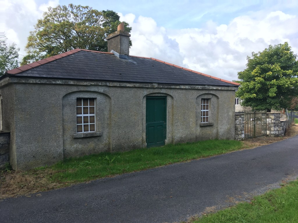
There is a small car park on the west side of Coolnahay Bridge (Dolan Bridge) across the road from the Lock Keeper’s Cottage that is fine to leave a car for several hours.

Looking west from Coolnahay Car Park

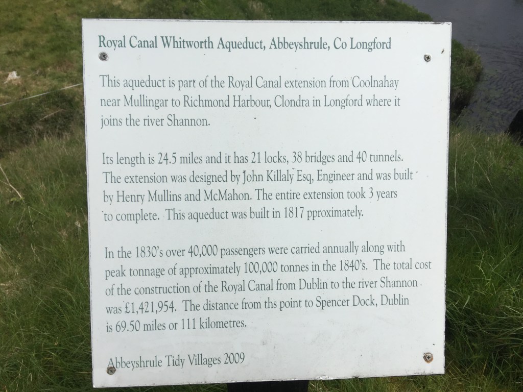
For those interested in the history of the building of the Royal Canal, Coolnahay also marks a very important point in the construction of the canal. The canal reached Coolnahay in 1809, some 19 years after construction first began in Dublin and by this stage the company was heavily in debt and unable to cover the construction costs to complete the canal. It was decided that the Royal Canal Company would be dissolved and the canal completed to the Shannon using public funds. In 1813 the Directors General of Inland Navigation took on to complete the canal under engineer John Killaly and contractors Henry, Mullins and McMahon. You may remember we previously came across the formation of this firm when they tendered for the restoration and extension of the Naas Branch of the Grand Canal as to Corbally Harbour.

Information sign at Whitworth Aqueduct about the construction of the Royal Canal from Coolnahay to Clondra.

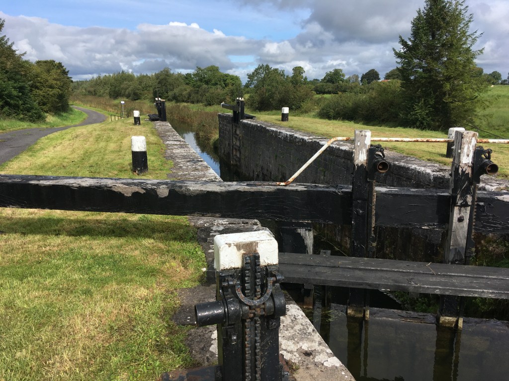
As previously mentioned, one of the advantages of this section is a continuous drop down through 10 locks to Ballynacargy. The other big advantage of this area is the pure scenic nature of the remainder of the canal. Mullingar is the last large urban centre we pass through on our way west and from Coolnahay we are truly out in the remote country side only passing through the odd small village or skirting around a small town. 400m from Dolan Bridge we come to the 27th Lock.

27th Lock Gates

Another 500m on from the 27th Lock we come to the 28th Lock which lies slightly around the next bend. Another feature of the Royal Canal as we move further west is that it begins to meander more through the landscape. For those of you who may have seen RTÉ’s Waterways: The Royal Canal series with Dick Warner, you may recall an interview with the daughter of the last lock keeper of the 26th Lock who discusses how her father, Michael Christie, would also look after the 27th and 28th Locks, cycling down to them from the cottage on the 26th Lock. As such it is no surprise that we do not find any cottages at these locks.

Looking up the 28th Lock Chamber

500m on from the 28th Lock we come to Walsh’s Bridge, an accommodation bridge over the canal. It is possible to walk under the bridge or to rise up over the road allowing for a good view down the canal.

Walsh’s Bridge on a soft day.

It is a 1.5km walk on from Walsh’s Bridge to Kildallan Bridge and the start of the quick descent down the 29th, 30th and 31st Locks.

29th Lock and Kildallan Bridge in the background

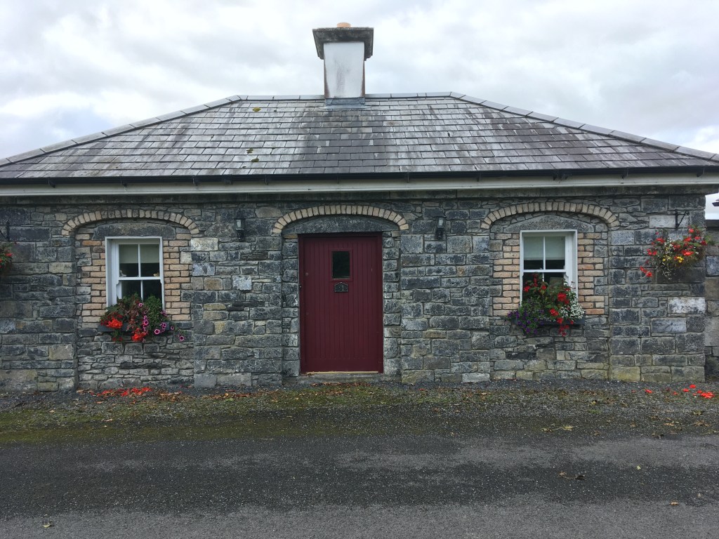
The three locks are in a linear stretch not long after the bridge. Each lock also has a restored Lock Keeper’s Cottage beside them.

Restored front of the 30th Lock Keepers Cottage

Each of these have been largely extended and modernised they make for appealing private residences on the bank of the canal.

31st Lock Keeper’s Cottage

The canal path takes a sharp left after the 31st Lock before taking a sharp right to be greeted by Kill Bridge and the 32nd Lock.

32nd Lock and Kill Bridge

Kill Bridge is another accommodation bridge, something more common the further west you go as farmers needed access both sides of the canal as it cut through the land.

Looking down the 33rd Lock

It is a little over 500m down to the 33rd Lock before a 1.2km straight on to Balroe Bridge and the 34th Lock.

34th Lock and Balroe Bridge

With the passing of the 34th Lock we are now onto our final 2km stretch towards the 35th Lock and Ballynacargy.

Ballynacargy Harbour looking towards the 35th Lock

As we pass the 35th Lock and its Lock Keeper’s Cottage the large and magnificent Ballynacargy Harbour opens out into our view.

35th Lock Keepers Cottage

On the south bank we see the remains of the old Hotel and Store House while the majority of the small village sits on the opposite bank. There are also a few picnic benches out around the harbour which makes it a pleasant place to stop.

Remains of Ballynacargy Hotel and Store

At the end of the harbour is Ballynacargy Bridge which will give you access to the village itself. The village has a few small pubs, newsagents, garage and a chipper so its possible to grab a snack or a drink before making the trip back to Coolnahay or onwards to Abbeyshrule where I will pick up in part 10 below.

Ballynacargy Bridge and Harbour

Part 1: North Wall to Cross Guns Bridge

Part 2: Cross Guns Bridge to Castleknock

Part 3: Castleknock to Leixlip Confey

Part 4: Leixlip Confey to Maynooth

Part 5: Maynooth to Enfield

Part 6: Enfield to Thomastown

Part 7: Thomastown to Mullingar Harbour

Part 8: Mullingar Harbour to Coolnahay

Part 10: Ballynacargy to Abbeyshrule

Part 11: Abbeyshrule to Ballybrannigan

Part 12: Ballybrannigan to the 41st Lock

Part 13: 41st Lock to Richmond Harbour

Part 14: The Lough Owel Feeder

Part 15: The Longford Branch

Annex 1: The Old Rail Trail – Mullingar to Athlone

Categories
Royal Canal

Royal Canal Greenway: Ballynacargy to Abbeyshrule

Distance: 8.8km

Keeping the sections short as I travel further west towards the Shannon, todays post covers the stretch from Ballynacargy to Abbeyshrule, an easy place to start, enjoy some time on the canal before having a good lunch and returning back the way you came.

Looking west from Ballynacargy Bridge

Leaving your vehicle in Ballynacargy village, much of which dates back to the time the canal was built, you will need to cross over Ballynacargy Bridge to join the greenway on the south bank of the canal. From here it is 1.5km to the 36th Lock and Bridge with adjacent former Lock Keeper’s Cottage which is now a private residence.

36th Lock, Bridge and Cottage

It is a little over 500m from the 36th Lock to Kiddy’s Bridge which you can pass under the arch if you want.

Kiddy’s Bridge

Staying on the south bank of the canal it is then 600m to the 37th Lock and Bridge.

37th Lock Gates seen from below the bridge

Once down onto the 37th Level you will see the 38th Lock with it’s Lock Keeper’s Cottage and Kelly’s Bridge only a short distance ahead. It is more common to find this matching set of lock, cottage and bridge on the western end of the canal, though the condition of the cottages can vary from ruins, to restored and also extended private residences.

38th Lock and Kelly’s Bridge

This whole section of the canal was dammed off west of Mullingar from the 1960’s until the 1990s’s with very little to water to speak of. As such some boats were abandoned where they lay. Once such boat is Heritage Boat 4E which is well worth looking up on the link. The boat has had an interesting life with several designations but it was from here that the current owner salvaged her in 1980 by having her towed to the 38th Lock and craned out so it could be brought to the Grand Canal to be restored. 4E can often be sighted on both canals and wintered in Mullingar Harbour over 2019/2020.

4E Pictured at Chambers Bridge

We cross over the bridge at the 38th Lock to the north bank before proceeding on 500m to Ledwith’s Bridge. From here the countryside opens up as we pass through Ballymaglavy Bog. The wide expanse of the bog offers no protection so always be prepared for Irish weather, sunscreen and a rain jacket.

Ledwith Bridge

As we move through the last stretch out of Westmeath before we enter our final county of Longford we come to a landmark that catches the attention of all those who pass, that of Bog Bridge. This stunning bridge lies in the middle of nowhere, spanning the canal, linking one side of the bog to the other but in our modern times looks like it serves no purpose other than to provide us a view of the bog and act as a perfect example of the fine workmanship of the contractors that built this section of the canal.

Bog Bridge

With Bog Bridge behind us we now enter County Longford as we approach Quinn’s Bridge.

Quinn’s Bridge

To the right of Quinn’s Bridge we can also see Abbeyshrule Aerodrome which is mainly used for leisure flights and parachute clubs.

Plane and hanger of Abbeyshrule Aerodrome viewed from the Canal.

About 600m past Quinn’s Bridge we come to the Whitworth Aqueduct which carries the canal over the River Inny and is one of the most impressive structures on the canal.

Whitworth Aqueduct from below

The 5 arch aqueduct was most likely named for Lord Charles Whitworth, who was Lord Lieutenant of Ireland between 1813 and 1817 when this section of the canal was being built.

Approaching the Whitworth Aqueduct with water from the River Inny being pumped up to the canal from below.

The canal takes a sharp left once you cross the aqueduct as you line up to come into Abbeyshrule itself. If you keep and eye out just as you round the corner you can see an original overflow before you get to Scally’s Bridge.

Overflow before Scally’s Bridge. There are several of these overflows between Coolnahay and Cloondara. The arch on this one is obscured by a flat plinth added at a later date

The Greenway section on the north bank from Scally’s Bridge into Abbeyshrule recently opened and is safer than crossing the narrow bridge to bring you into the village. When you reach the village though you will need to cross Webb Bridge to either stop in the town or to carry on.

The approach to Abbeyshrule from Scally’s Bridge. The Greenway is now open on the right side as the main road goes in on the left.

Abbeyshrule is the site of of a Cistercian Abbey dating back to the 1200’s and poet Oliver Goldsmith is believed to have been born nearby.

Looking through the ruins of the abbey

The village also boasts a very active Tidy Towns group.

Abbeyshrule Sign with some of its Tidy Town accolades.

At the heart of the village you will find the Rustic Inn where I would highly recommend you stop in for a drink and a feed. The pub also has a guest house for those looking to rest their tired legs after a long walk, run or cycle.

A great feed is always to be had at the Rustic Inn

Once refueled you are all set to make the return journey to Ballynacargy to to push on further west to Ballybrannigan and Ballymahon where I will pick up in my next post.

Part 1: North Wall to Cross Guns Bridge

Part 2: Cross Guns Bridge to Castleknock

Part 3: Castleknock to Leixlip Confey

Part 4: Leixlip Confey to Maynooth

Part 5: Maynooth to Enfield

Part 6: Enfield to Thomastown

Part 7: Thomastown to Mullingar Harbour

Part 8: Mullingar Harbour to Coolnahay

Part 9: Coolnahay to Ballynacargy Bridge

Part 11: Abbeyshrule to Ballybrannigan

Part 12: Ballybrannigan to the 41st Lock

Part 13: 41st Lock to Richmond Harbour

Part 14: The Lough Owel Feeder

Part 15: The Longford Branch

Annex 1: The Old Rail Trail – Mullingar to Athlone