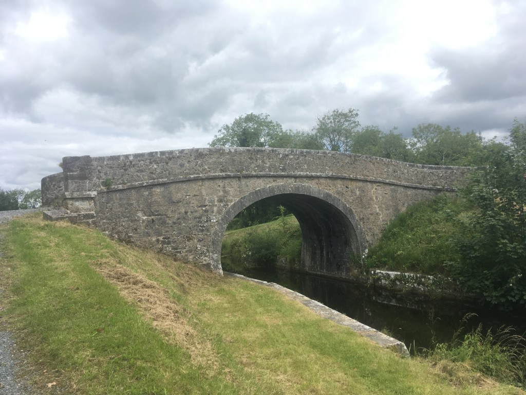
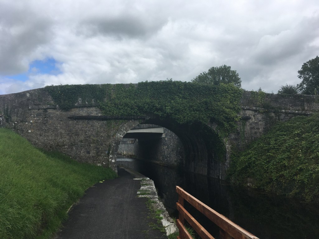
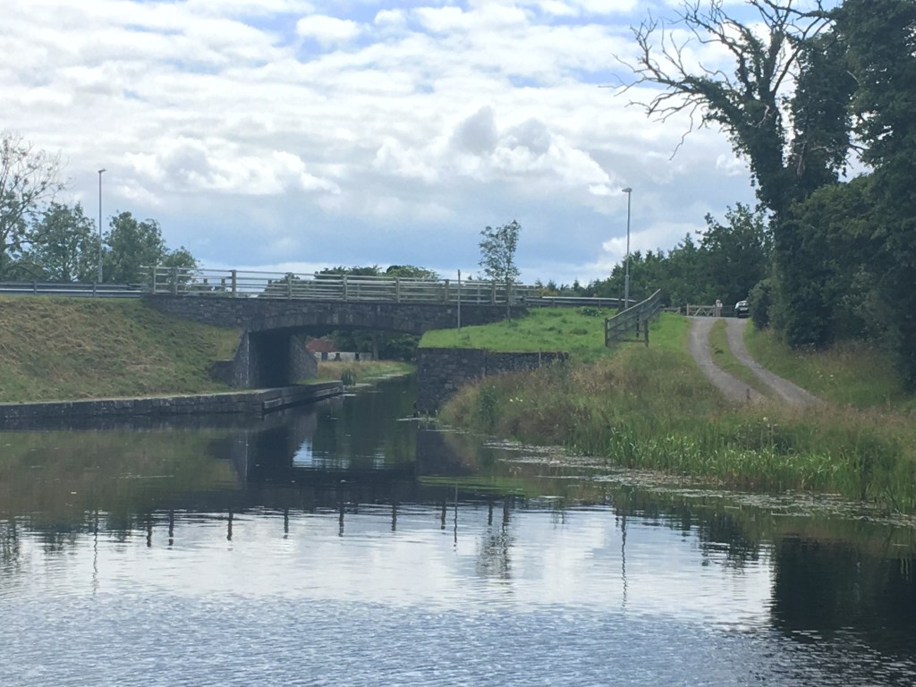
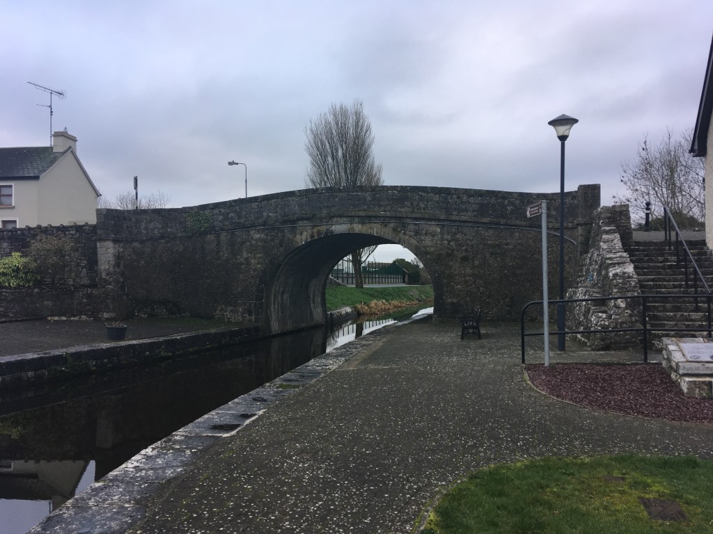
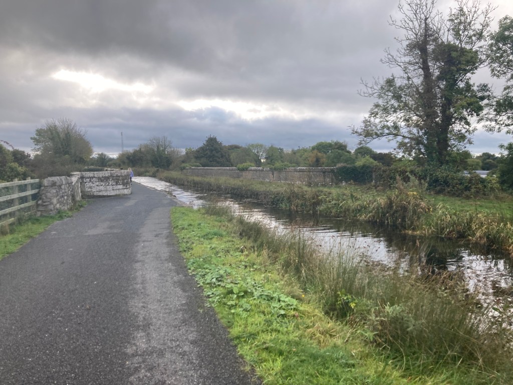
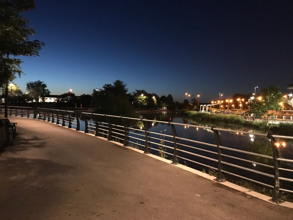
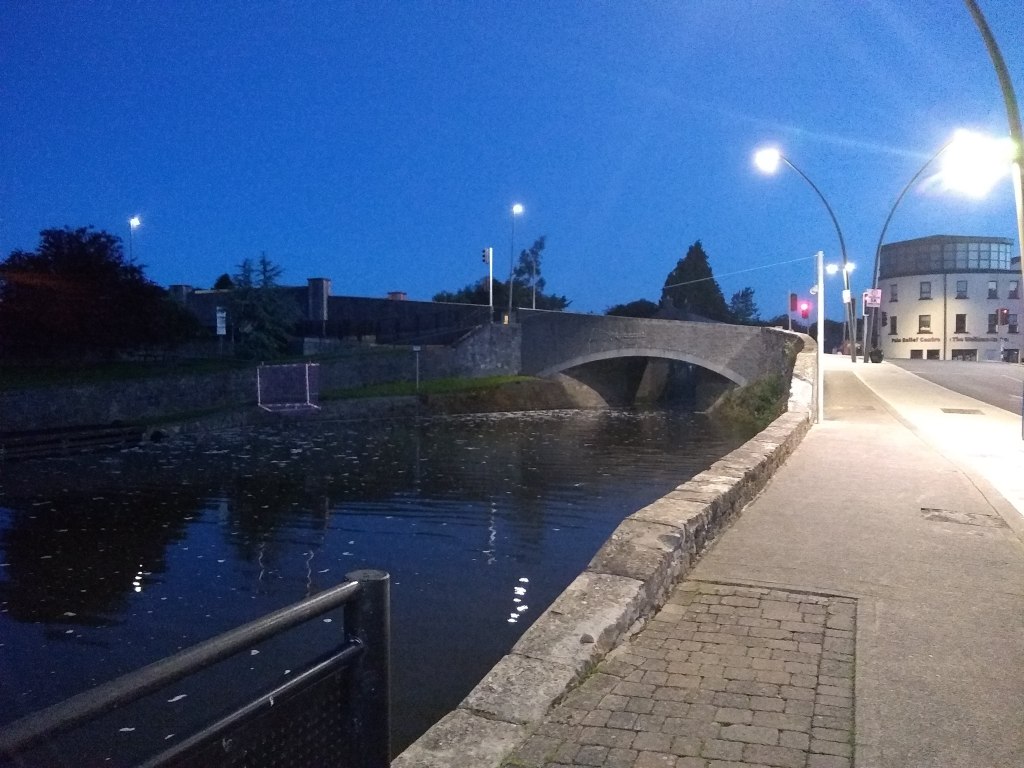
Keeping the sections short as I travel further west towards the Shannon, todays post covers the stretch from Ballynacargy to Abbeyshrule, an easy place to start, enjoy some time on the canal before having a good lunch and returning back the way you came.
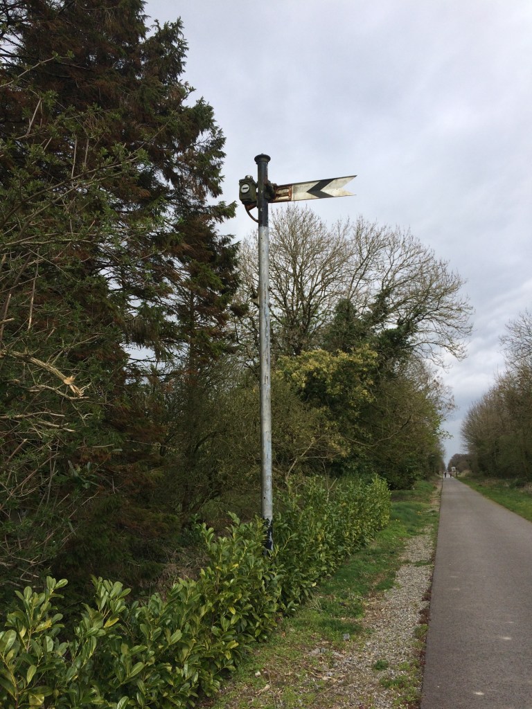
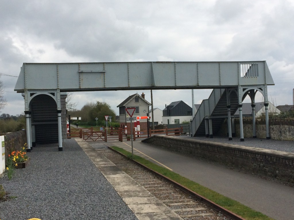
Looking west from Ballynacargy Bridge
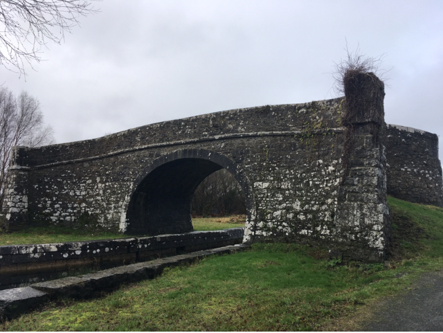
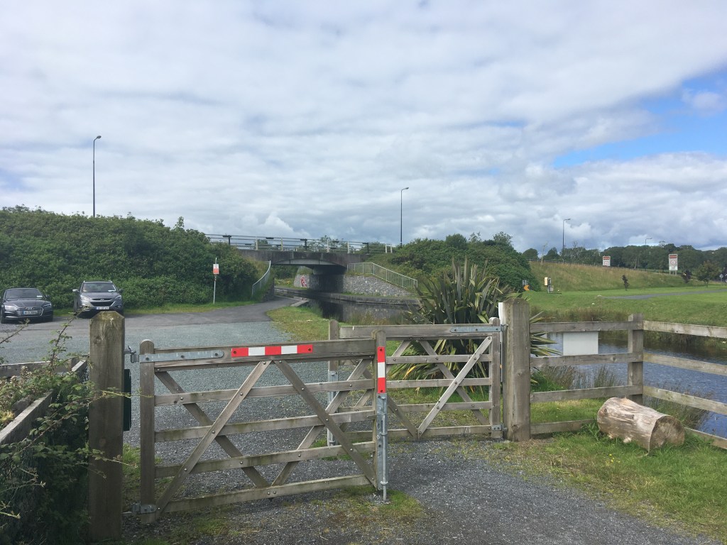
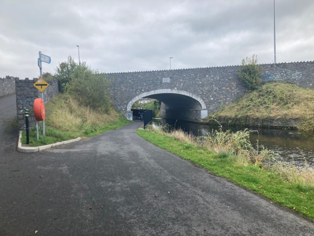
Leaving your vehicle in Ballynacargy village, much of which dates back to the time the canal was built, you will need to cross over Ballynacargy Bridge to join the greenway on the south bank of the canal. From here it is 1.5km to the 36th Lock and Bridge with adjacent former Lock Keeper’s Cottage which is now a private residence.
36th Lock, Bridge and Cottage
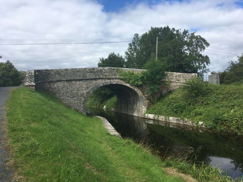
It is a little over 500m from the 36th Lock to Kiddy’s Bridge which you can pass under the arch if you want.
Kiddy’s Bridge
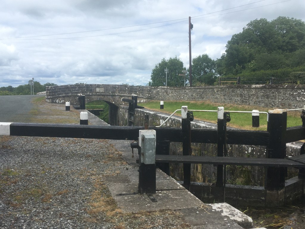
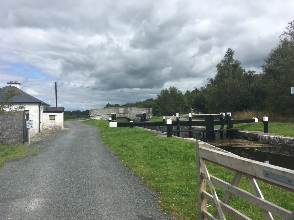
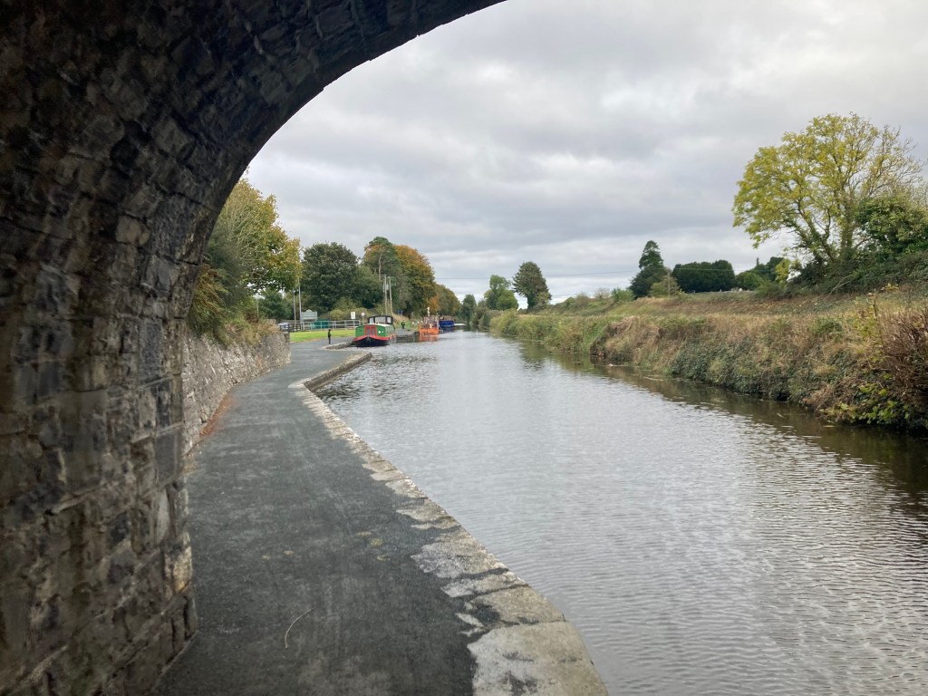
Staying on the south bank of the canal it is then 600m to the 37th Lock and Bridge.
37th Lock Gates seen from below the bridge
Once down onto the 37th Level you will see the 38th Lock with it’s Lock Keeper’s Cottage and Kelly’s Bridge only a short distance ahead. It is more common to find this matching set of lock, cottage and bridge on the western end of the canal, though the condition of the cottages can vary from ruins, to restored and also extended private residences.
38th Lock and Kelly’s Bridge
This whole section of the canal was dammed off west of Mullingar from the 1960’s until the 1990s’s with very little to water to speak of. As such some boats were abandoned where they lay. Once such boat is Heritage Boat4E which is well worth looking up on the link. The boat has had an interesting life with several designations but it was from here that the current owner salvaged her in 1980 by having her towed to the 38th Lock and craned out so it could be brought to the Grand Canal to be restored. 4E can often be sighted on both canals and wintered in Mullingar Harbour over 2019/2020.
4E Pictured at Chambers Bridge
We cross over the bridge at the 38th Lock to the north bank before proceeding on 500m to Ledwith’s Bridge. From here the countryside opens up as we pass through Ballymaglavy Bog. The wide expanse of the bog offers no protection so always be prepared for Irish weather, sunscreen and a rain jacket.
Ledwith Bridge
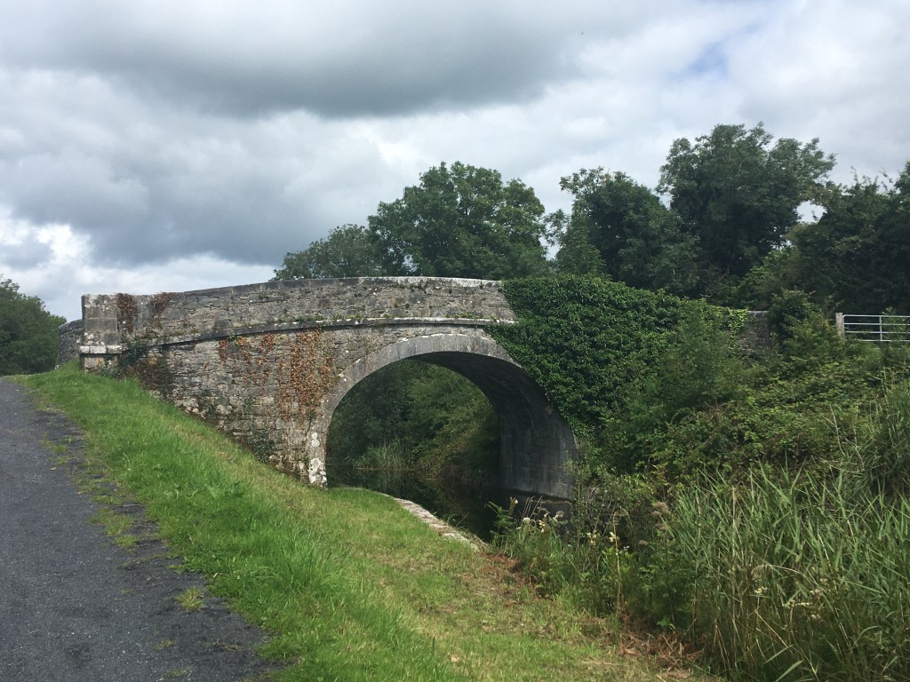
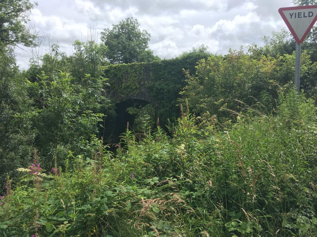
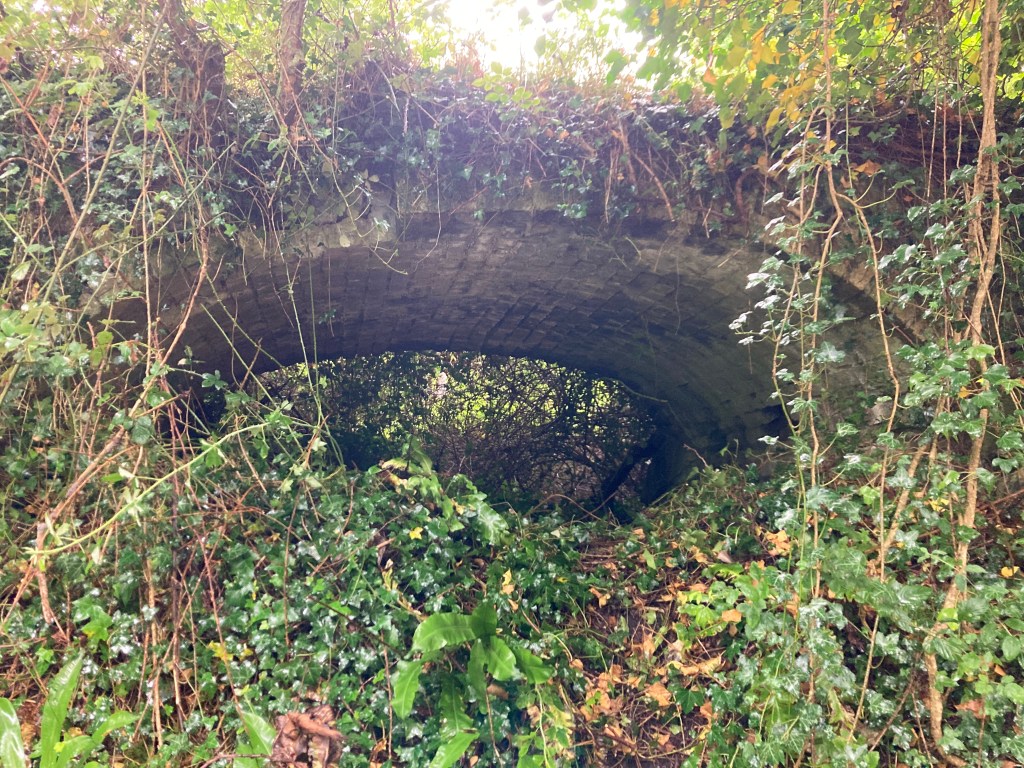
As we move through the last stretch out of Westmeath before we enter our final county of Longford we come to a landmark that catches the attention of all those who pass, that of Bog Bridge. This stunning bridge lies in the middle of nowhere, spanning the canal, linking one side of the bog to the other but in our modern times looks like it serves no purpose other than to provide us a view of the bog and act as a perfect example of the fine workmanship of the contractors that built this section of the canal.
Bog Bridge
With Bog Bridge behind us we now enter County Longford as we approach Quinn’s Bridge.
Quinn’s Bridge
To the right of Quinn’s Bridge we can also see Abbeyshrule Aerodrome which is mainly used for leisure flights and parachute clubs.
Plane and hanger of Abbeyshrule Aerodrome viewed from the Canal.
About 600m past Quinn’s Bridge we come to the Whitworth Aqueduct which carries the canal over the River Inny and is one of the most impressive structures on the canal.
Whitworth Aqueduct from below
The 5 arch aqueduct was most likely named for Lord Charles Whitworth, who was Lord Lieutenant of Ireland between 1813 and 1817 when this section of the canal was being built.
Approaching the Whitworth Aqueduct with water from the River Inny being pumped up to the canal from below.
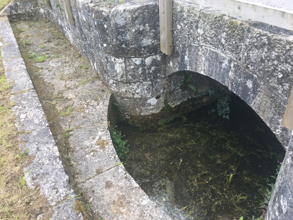
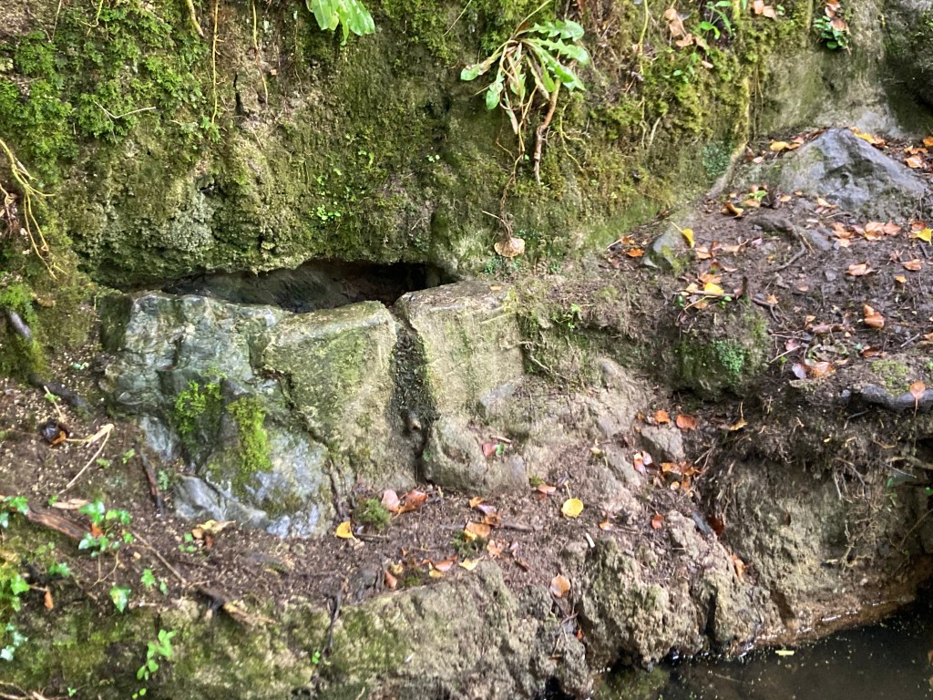
The canal takes a sharp left once you cross the aqueduct as you line up to come into Abbeyshrule itself. If you keep and eye out just as you round the corner you can see an original overflow before you get to Scally’s Bridge.
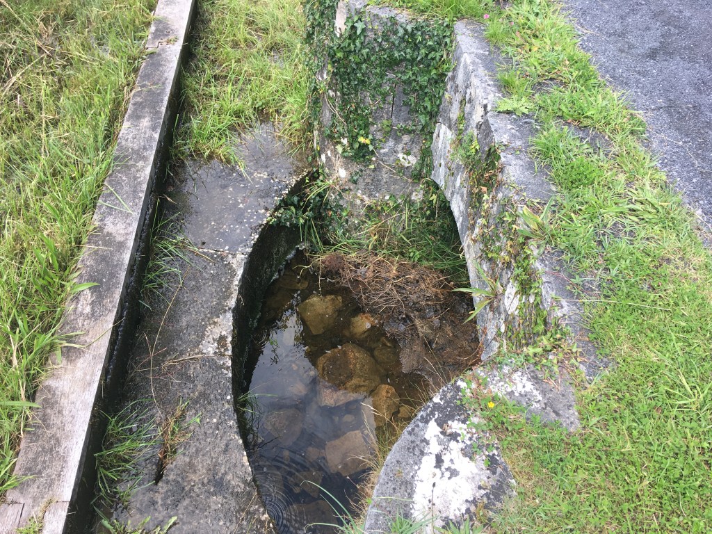
Overflow before Scally’s Bridge. There are several of these overflows between Coolnahay and Cloondara. The arch on this one is obscured by a flat plinth added at a later date
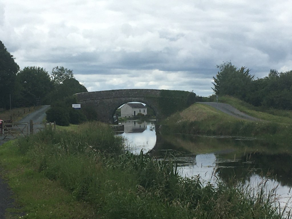
The Greenway section on the north bank from Scally’s Bridge into Abbeyshrule recently opened and is safer than crossing the narrow bridge to bring you into the village. When you reach the village though you will need to cross Webb Bridge to either stop in the town or to carry on.
The approach to Abbeyshrule from Scally’s Bridge. The Greenway is now open on the right side as the main road goes in on the left.
Abbeyshrule is the site of of a Cistercian Abbey dating back to the 1200’s and poet Oliver Goldsmith is believed to have been born nearby.
Looking through the ruins of the abbey
The village also boasts a very active Tidy Towns group.
Abbeyshrule Sign with some of its Tidy Town accolades.
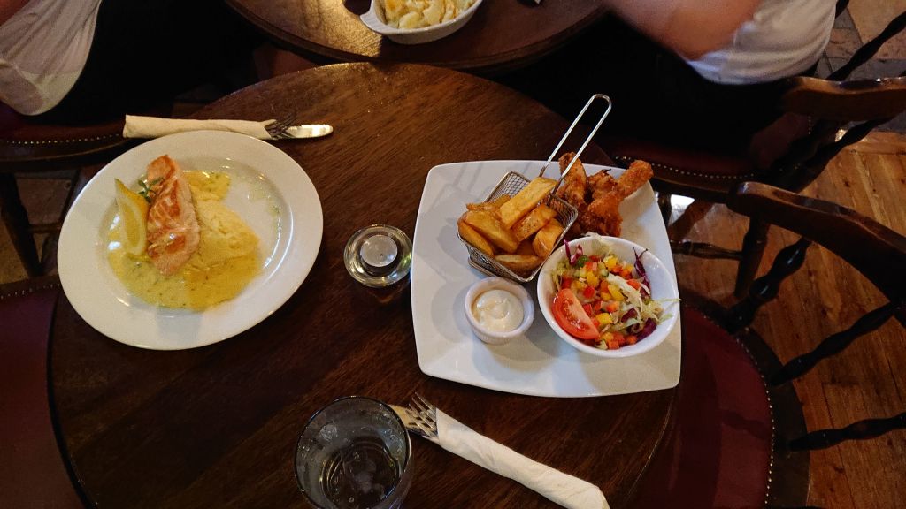
At the heart of the village you will find the Rustic Inn where I would highly recommend you stop in for a drink and a feed. The pub also has a guest house for those looking to rest their tired legs after a long walk, run or cycle.
A great feed is always to be had at the Rustic Inn
Once refueled you are all set to make the return journey to Ballynacargy to to push on further west to Ballybrannigan and Ballymahon where I will pick up in my next post.
The section between Abbeyshrule and Ballybrannigan Harbour just outside of Ballymahon is one of the quietest and most picturesque sections of the Royal Canal and well worth the visit to meander around the many bends of the canal here. Leaving Abbeyshrule we first cross over Webb Bridge to the southern bank of the canal which we will stay on for this entire stretch.
Webb Bridge looking west from Abbeyshrule
Descending down on the other side of Webb Bridge there is a playground and some picnic benches. As previously mentioned, Abbesyshrule has a very active and proud Tidy Towns group and this can be seen by all the effort gone into with planting, sculptures and public areas around the harbour both sides of the bridge. If you look to the left beyond the River Inny you can see the ruins of the Abbey and its bell tower in the distance by the graveyard.
Ruins of Abbeyshrule Abbey
Rounding the corner leaving Abbeyshrule it is 1.5km to the 39th Lock at Draper’s Bridge. The 39th Lock is the only lock we will encounter today and the 39th Level is the longest level on the western side of the Summit Level being a little over 11km long before reaching the 40th Lock.
39th Lock and Draper’s Bridge
Almost hidden behind the overgrowth beside the 39th Lock is the remains of the Lock Keeper’s Cottage. Behind a house on the main road the walls remain intact of this two room cottage, same in design as many of the previous ones we’ve seen but sadly the roof has come in and not much else remains except for the two fireplaces.
One of the fireplaces inside the remains of the Lock Keeper’s Cottage at the 39th Lock.
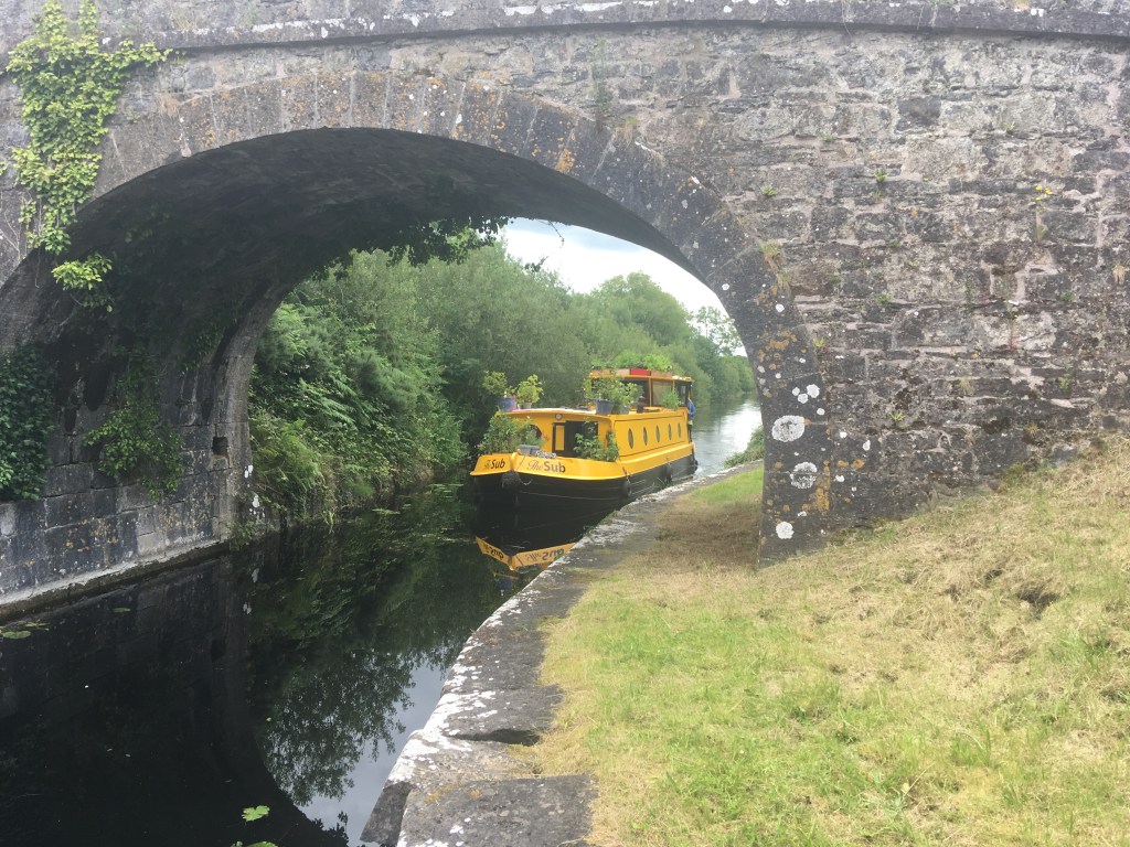
A little over 1.5km on from the 39th Lock with come to Allard’s Bridge which is an accommodation bridge allowing farmers access to both sides of the canal. It is possible to pass under the bridge and if you do you can see a cut into the stone on both sides that allows wooden boards to be places to stop the water. These slots can be found at several bridges and are useful when you need to stem the water when carrying out maintenance or fixing a breach.
Slots in the stone work of Allard’s Bridge to slide in wooden slats to stop the water and allow of maintenance
As I was passing Allard’s Bridge on my most recent trip I came across Riversdale Holidays The Sub barge passing under the Bridge as it was heading west. The Sub is available for hire by holiday makers for those looking to take a leisurely break on the Royal Canal.
The Sub passing under Allard’s Bridge
A little over 1km from Allard’s Bridge is Guy’s Bridge. This is another accommodation bridge though it is my understanding that from here it is now possible to cross down to the bank of the Inny and onto Newcastle Woods before crossing the restored White’s Bridge which will bring you into the new Longford Centre Parcs. I seem to have missed this new path completely so I will need to go back and confirm and will update this post accordingly when I have.
Guy’s Bridge which you can pass under or climb up to get a view of the canal.
After passing Guy’s Bridge there is a sharp right hand bend to bring you up the straight towards Molly Ward’s Bridge which lies just 500m beyond. Molly Ward’s Bridge is also an accommodation bridge and seeing these three almost uniform bridges in a row shows the great skill of the workmen who built them. All built to the same design they stand proud in their surroundings over 200 years later, surviving the downturn of the canal, its closing and then its restoration.
Molly Ward’s Bridge
1km further on we come to Fowlard’s or Cloonard Bridge which carries the N55 road from Edgeworthstown to Ballymahon. Unfortunately being such an important road, the original narrow humpback bridge is gone, only the limestone retaining walls remaining. When passing under the concrete structure you can see marks of where the modified bridge passed at a much lower level as clearance for boats was no longer necessary when then canal was closed. Thankfully Longford County Council altered, raised or rebuilt several bridges that they had only made culverts for when the Royal Canal closed to trade to once again allow for navigation.
The outline of height of the span of Fowlard’s Bridge before it was raised to allow for boats to navigate again on the reopening of the canal
1.5km from on from Fowlard’s Bridge we come to Toome Bridge. It was from here that passengers on the Royal Canal boats could catch a Bianconi Coach to Athlone up until the Midland Great Western Railway opened their station in Athlone around 1850.
Toome Bridge
A little over 1km from Toome Bridge we cross over one of the several spillways on the canal extension built between Coolnahay and Cloondara. This one is similar to the one previously mentioned near the Whitworth Aqueduct but retains its original arch without a plinth blocking it. Theses spillways had a raised shelf where excess water would spill over down under the arch and to a water source below.
Overflow shelf and arch of spillway west of Toome Bridge
It is slightly short of 1km to Chaigneau Bridge and Ballybrannigan Harbour from the overflow. The bridge still retains a turnstile type gate underneath it which used to be found at several of these bridges so it is easier to go up and over this bridge to enter the harbour area.
Chaigneau Bridge with the restored ticket office visible through the arch.
Over the bridge the canal opens up to one of its more substantial harbours with boats often found mooring here. Standing prominently over the harbour is also the remains of an old canal storehouse which is increasinly being consumed by ivy.
Canal Store at Ballybrannigan
At the end of the harbour is the restored ticket house which to the best of my knowledge is used by the Royal Canal Amenity Group.
Restored ticket office at Ballybrannigan Harbour
Not far from the ticket office at the wall of the harbour you can still make out the engraving marking the restoration of the harbour and this part of the canal by the Royal Canal Amenity Group and the Office for Public Works in 1995. The O.P.W. had responsibility for the canal before the establishment of Waterways Ireland.
Engraving marking the restoration of this part of the canal in 1995. I think the image on the left is the O.P.W. logo.
It is about a 2km walk from the harbour into the small town of Ballymahon where there are several pubs and shops to eat or get supplies. However the town is best reached from Longford Bridge which I will cover in the next section.
Ballybrannigan as previously mentioned is a harbour just to the north of Ballymahon. Before taking to the Greenway to the 41st Lock, I decided to call into the town for some lunch to fuel for my walk. Ballymahon has a very wide main street with plenty of parking and local pubs, garages and shops to make it worth the 2km diversion off the canal. This time around I had a fantastic meal at Cooney’s Hotel on the main street.
Cooney’s Hotel, Ballymahon
Once I had my fill I was back to Ballybrannigan Harbour where there is some limited parking beside the old canal storehouse. Heading west on the south bank of the canal it is 1.5km from the harbour to Longford Bridge. This bridge is a relatively new addition to the canal carrying the R392 from Lanesborough to Ballymahon. The bridge replaced a culvert that previously blocked the navigation of the canal. Some limited parking is also available on the east side of the bridge and is a popular spot with locals taking short walks on the Greenway.
Approaching the gates at Longford Bridge and Car Park
Truth be told Longford Bridge is more ideally suited to come on and get off the canal for Ballymahon as it leads straight down to the main street albeit a similar distance as Ballybrannigan. On the left of the gates the wall of the car park area has several paintings of the canal done by local artists.
Art at Longford Bridge
Passing under the bridge and staying on the south bank as we do the whole way to Mosstown Harbour, it is less than 1km before we reach Archie’s Bridge along with its canal storehouse and another building which may have once served as a ticket office. If you look closely you will also see evidence of the quay wall at the bridge.
Canal buildings on the west side of Archie’s Bridge
It is possible to pass under Archie’s Bridge or to come up to the main road level before descending down on the other side. As there is a main road going over the bridge it is advisable to dismount your bike before crossing over and to be aware of traffic.
Archie’s Bridge
Along the 1.5km from Archie’s Bridge to the 40th Lock with its accommodation bridge and lock keeper’s cottage at Mullawornia the canal takes a definitive turn towards the north.
40th Lock, Accommodation Bridge and Lock Keeper’s Cottage with extended porch
Consideration had been made to carry on west when building the canal straight to Lough Ree from this point in order to save costs however the Grand Canal Company opposed this and insisted that the Royal Canal be completed to it’s original planned terminus at Cloondara some 19km’s further on. As you round the corner after the lock you can see the bedrock of Mullawornia Hill as the canal skirts around it and a steep drop off the Greenway on the other side.
Canal turning north around Mullawornia Hill
It is just under 1km from the 40th Lock to the Pake Bridges where we again cross under the R392. We come to the original Pake Bridge first passing under it before we pass under the abutted new bridge which was rebuilt from a culvert to allow for full navigation of the canal. There is a sharp turn to the left as you come out from the new bridge. Unlike the long stretches of many of the previous sections the canal twists and turns more and more as we near its end.
The original Pake Bridge with the new one hidden behind it
1.5km from the Pake Bridges we come to Foigha Harbour and Bridge. I think calling this a harbour is a little generous but there is a jetty with room to tie up a few small boats the east side of the bridge.
Foigha Harbour and Bridge
If at this point you are looking to take a small break, Leavy’s of Foigha is only 300m from the bridge and while the grocery shop has closed the pub is still up and running.
Leavy’s of Foigha
Back on the south bank of the canal it is just under 2km to the next landmark of Cloonbreany Bridge. Leaving Foigha it does feel like the Greenway passes right through the front of a private garden but rest assured you are on the right side as you pass through the familiar wooden gates. I once led a group down the other bank to find us having to climb gates and hop over cow pats before correcting ourselves at the next bridge.
Cloonbreany Bridge
Between Cloonbreany and Mosstown Harbour we pass alongside Corlea Bog which includes a visitor centre for the Corlea Trackway, an old trackway that dates back to 148-147BC. A walk has been built around the bog much like the surface of the Greenway and links the canal directly to the visitor’s centre for those who have the time and interest to take the small diversion off the canal.
Sign for the Corlea Bog Amenity Walk where it meets the canal
Not far from where we meet the Corlea Bog Amenity Walk we come to Island Bridge which lies on the outskirts of the village of Keenagh. A new path links the canal to the village and is only a short distance for those looking for a shop.
Island bridge from Mosstown Harbour
Island Bridge is another location that had been culverted when the canal had closed and has since been been replaced with a higher bridge to allow for navigation of the canal once again. It is necessary to come up onto the bridge to cross the canal before coming down into Mosstown Harbour on the other side.
Mosstown Harbour from Island Bridge
Mosstown Harbour has a small car park and several picnic benches beside it and is probably a more suitable spot for starting or stopping along this section however for this post I will be pushing on just a little further. A gathering of boats celebrating the 200th Anniversary of the opening of the Royal Canal was filmed at Mosstown Harbour in 2017:
A little beyond the car park on the road that leaves the canal path is a gate house for Mosstown House which was demolished in the early 1960’s.
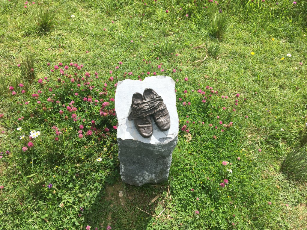
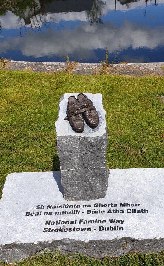
National Famine Way Shoes Memorial at Mosstown Harbour
Mosstown House is of note to us canal enthusiasts as the home of Newcomen family. Sir William Gleadowe-Newcomen was a banker and politician who was also an early subscriber of the Royal Canal Company, the bridge at the 1st Lock on North Strand Road being named for him. While the house is lost and is now the site of a modern farm, the remains of the Mosstown pigeon house can be found not far from the canal. A small cottage can also be found on the opposite bank.
Cottage near Mosstown Harbour
Not far from the harbour is another one of the overflows we previosuly encountered around Abbeyshrule. There is a former mill close to the spillway which dates from around the same time as the canal and some associated works where the canal may have even supplied water can be spotted along this stretch.
41st Lock Chamber and Lock Keeper’s Cottage from Coolnahinch Bridge
There is no suitable parking here so if stopping for collection Mosstown Harbour does make more sense. For me though I will be walking back to pick up my car at Ballybrannigan Harbour and grabbing a bite to eat in Cooney’s Hotel before the drive home. For those pushing on it is only 13km to the end of the canal at Richmond Harbour.
From our starting point at the 41st Lock we will reach the end of the Royal Canal where it joins the Camlin River at the 46th Lock just beyond Richmond Harbour in Cloondara.
41st Lock Chamber and Coolnahinch Bridge
We are now over 130km from our starting point at the Sea Lock on the Liffey. We have left urban Dublin, passed through the commuter towns of north Kildare, eased by the green pastures of Meath, summitted the canal as we passed through Westmeath and are now gently descending towards the Shannon in Longford.
GPX Trace of the Royal Canal
We start on the south or what could more likely described as the west bank of the Royal Canal as we now head north towards our destination. It is 1.5km to Ard’s Bridge, an accommodation bridge that can be walked under or ascended over depending on the view you want.
Less than 1km from the lock we reach the Lyneen or Ballinamore Bridges which similar to several bridges we have come to west of Mullingar includes the original canal crossing beside a much newer road bridge. It is necessary to ascend up the road bridge and cross the canal over to the other side to continue our journey but be mindful that this is a busy road.
Lyneen Old Bridge with the new bridge visible through the arch
Down on the other side we continue on for 1km to the Lower Lyneen or Crossover Bridge. This bridge is on the approach to the Longford Junction of the canal and was originally built to enable horses which would have towed boats from the western bank of the canal to Cloondara to cross over the canal so that they could tow their boats on towards Longford Harbour. As the Greenway travels along the east bank now there is no need to cross the bridge but it does afford the wanderer a chance to rise up and take a good view.
Crossover Bridge
A little further on from the bridge are the ruins of a small canal building on the opposite bank.
Ruins near Longford Junction
Not much further on we come to the junction with the Longford Branch at Cloonsheerin. There is a decent path the whole way from the junction into Longford town and for those using a train it may be more useful to take this route which I discuss here. The Longford Branch is roughly 8.5km long so is similar in distance from this point to Cloondara.
The dam between the main branch and the Longford Branch at Cloonsheerin
Crossing the Longford Branch is simple as the Greenway is carried over the junction on the dam between the main line and the branch. It is just under 1.5km from here to the 43rd Lock and Aghnaskea Bridge. There is also a restored Lock Keeper’s Cottage at the 43rd Lock.
43rd Lock Chamber from Aghnaskea Bridge
Behind the cottage is St. Patrick’s Church. The church was built in 1829. Cruciform in plan, it was built by the Rev. Richard Farrell on land donated by the New Royal Canal Company.
St. Patrick’s Church
Aghnaskea is roughly 1km from Killashee village and is the best opportunity along this section to pick up supplies from a shop in the village. Magans is a popular pub in the village and a stopping point for many a traveler.
Clock Tower dedicated to the King-Harmon Family in Keenagh
Returning to the canal on the western bank it is a little over 500m to the 44th Lock and Savage Bridge. There is also a restored Lock Keeper’s Cottage at the lock including a plaque honouring Frances K. Kelly of Forrest Hills, New York who paid for the restoration of the house in 1990.
Restored 44th Lock Keepers Cottage
1km on from the 44th Lock is Ballydrum Bridge just before the canal enters Begnagh Bog.
Ballydrum Bridge
As we pass through the bog we come to the Begnagh Lifting Bridge and the original Begnagh Bridge. The lifting bridge carries the main road between Killashee and Cloondara and this road must be crossed also to carry on along the Greenway. The bridge’s operation is generally automatic, with boats triggering sensors that close the road barriers and lift the bridge for passage underneath.
Begnagh Lifting Bridge from Begnagh Bridge
1.5km on there is another lifting bridge, this time carrying a Bord Na Mona narrow gauge railway over the canal. The railway connects to Lanesborough Power Station which is due to close by the end of 2020.
Bord Na Mona Railway Lifting and Machinery Bridges
A walking and cycling trail is under construction across sections of bogland to connect Lanesborough to the Royal Canal Greenway. This trail will link Kilnacarrow, a short walk from Lanesborough, with Cloondara. I will endeavour to post further information about this link in the near future. There is also a vehicle access bridge just beyond the lifting bridge giving machinery access to both sides of the bog.
45th Lock looking towards Cloondara
As we reach the end of the bog we get to the 45th Lock at Rinnmount. After we leave the 45th Lock the Royal Canal takes one final turn north east before entering Cloondara which name comes from the Irish Cluain Dá Ráth meaning ‘pasture of two ringforts’.
The final turn of Royal Canal
Entry into the village is gained by passing under the horse shoe arch of Richmond Bridge. As with the previous bridges, the towpath is on the western side of the canal.
Richmond Bridge from the harbour
This opens out into Richmond Harbour, the focal point of the village where many of the buildings around it were built to service trade on the canal. The west bank of the harbour has been developed as a local amenity with a service block including toilets, showers and a Waterways Ireland office beside the bridge as well as a small car park and playground adjacent to the harbour and its moorings.
Richmond Harbour with playground on the opposite side
The Richmond Inn lies at the entrance to the harbour on the east bank. Originally a flax mill built in 1821, this four storey building now serves as a pub and guest house and is the perfect place for any explorer to finish their travels along the Royal Canal with five guest rooms and food served daily. Although it has been altered and changed to reflect its modern function, the scale of the building overlooking the harbour is suggestive of its past and the industrious nature of the canal itself.
Fantastic Feast at the Richmond Inn
Two doors down from The Richmond Inn is the former Harbour Master’s Office which was built around 1825 and is now in use as a private residence. It has a carved limestone date plaque beside the doorway. A slightly earlier office from about 1820 lies attached next door with a square headed carriage arch. Again this has been converted into a private residence.
Richmond Harbour Sign
Aside from the dry dock we encountered in Mullingar Harbour, Richmond Harbour has the only other remaining dry dock on the Royal Canal. Built in 1817, the dry dock in oblong in shape with a central drainage channel and integral staircase. Access is through a set of gates on the south side of the dry dock at the harbour and there is a sluice/drainage gate to the north side of the dry dock.
Richmond Harbour Dry Dock
Slightly to the west of the dry dock at the northern end of the harbour is the last Lock Keeper’s Cottage on the Royal Canal. The cottage is adjacent to the 46th Lock which lies to the northwest of the harbour and marks the last lock on the Royal Canal and where it meets the Camlin River.
46th Lock down into the Camlin
It is not possible for the walker or cyclist to proceed beyond this point and I would suggest they go back to the Richmond Inn for a pint but for the purposes of completeness (and boaters) I will briefly mention the last small stretch along the Camlin River required to get a boat out onto the River Shannon.
Start of the Shannon Navigation
After transiting through the 46th Lock down onto the Camlin River you must head north to avoid the weir which lies on the other side of Richmond Harbour. The cut limestone weir on the river predates the canal by about 50 years. Before reaching the road bridge which carries the N5 over the Camlin River from Longford to Termonbarry we turn west onto the Camlin Canal which is a very short canal linking the Shannon River to the Camlin River and was built in the 1760s. This small canal was most likely designed by Thomas Omer for the Commissioners for Inland Navigation. This small canal has a single bridge crossing it which would have carried the original road to Termonbarry and dates to the same time as the construction of the Camlin Canal. The bridge gives a good viewing platform for the pedestrian to see the majority of the link between the Camlin River and the Shannon River and can be accessed by heading northwest out of Cloondara past the derelict Richmond Mill. There is a Lock Keeper’s Cottage to be found on the north bank by the bridge. This cottage from the 1760’s is quite different to anything else we have encountered and also served as an office for the Shannon Navigation Company but is now disused. That said big boats are not an uncommon sight entering the Royal Canal via the Camlin as can be seen on this video:
The associated and only lock on the Camlin Canal lies to the west of the cottage. The large lock was first built around 1760 and was altered around 1815 with the coming of the Royal Canal. This lock serves as the last man made structure needed to connect the River Shannon to the River Liffey. Once through the lock you are finally out on the River Shannon with Termonbarry Harbour facing you on the opposite bank of the wide river. From here it is possible to navigate north up to Enniskillen and the Erne, south to Athlone and on to Limerick or should you choose to Shannon Harbour where you can turn east once again and follow the Grand Canal back all the way to the south bank of the Liffey only a short distance from where we started.
The Longford Branch of the Royal Canal was built several years after the Main Line was completed to Cloondara in 1817. Offically opened in January 1830 the branch is roughly 8.5km long but has since been shortened slightly after Longford Harbour was filled in and the new terminus moved to the south side of the railway line. While the branch is not navigable an accessible path runs the full length of it to the main line and is suitable for walkers, runners and cyclists.
Example of the path near Churchlands Bridge
As the branch is located close to the railway station I thought it would be a good idea to start this post at the old Longford Harbour and head out towards Cloonsheerin and the junction with the Main Line.
Longford Harbour Master’s House
The former Harbour Master’s House now sits overlooking a car park where the harbour once was. According to the Guide to the Royal Canal if the harbour were to be re-excavated, all of the original stonework is in situ under the compacted infill.
Former Royal Canal Ticket Office at Longford Harbour
Another prominent building on the site of the infilled harbour is listed by the National Inventory of Architectural Heritage as being the former Royal Canal Ticket Office and may have been originally built as a warehouse or store for the canal. With the harbour now gone you can follow a path down underneath the railway to the other side where the new terminus of the canal is now.
Railway sheds as seen from the new terminus of the canal. The lie off to one side between the new terminus and the old harbour.
The first 1.5km of the canal from the new terminus to just beyond Farranyoogan Bridge holds water and is home to a considerable number of ducks, moorhens, butterflies and dragon flies. Longford County Council also recently finished upgrading the canal path on both sides with a smooth tarmac surface and lighting from the start as far as Churchlands Bridge, a distance of nearly 3km.
Watered section of Longford Branch with tarmac paths and lighting on both sides of the canal.
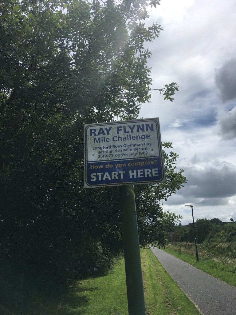
This section the of the canal is the venue of the popular Run Canal Run Longford which offers runners a choice of 10k, half marathon, full marathon and an ultra marathon running loops up one side and back the other between the terminus and Churchlands Bridge. This section also celebrates Irish athlete and Longford native Ray Flynn who ran an impressive 89 sub 4 minute miles over the course of his career and still holds the Irish 1 mile record with a time of 3:49.77 ran in Oslo in July 1982.
Ray Flynn Mile Challenge sign on the Canal Path
The first bridge we come to, a little less than 1.5km from the harbour is Farranyoogan Bridge and is the most prominent and visible bridges along the Longford Branch. It is possible to pass under the bridge on the eastern side of the canal.
Farranyoogan Bridge
A very short distance after the bridge there is a dam which ensures the first section we have just completed remains watered from the local springs nearby. From here on to the junction with the Main Line is dry. It is a little over 1km from Farranyoogan Bridge to Churchlands Bridge and the canal bed is visible for almost all of this section, with much of the overgrowth that was in the canal removed when the paths were done.
The dry bed of the canal between Farranyoogan Bridge and Churchlands Bridge.
Churchlands Bridge is a now out of use bridge built in the first half of the 20th century on the site of a former canal bridge dating back to the building of the Longford Branch.
Churchlands Bridge as viewed from the Longford town side.
Unfortunately after the closing of the canal in the early 1960’s several culverted road crossing at the canal level were built by Longford County Council to by-pass the narrow and often hump backed bridges of the canal that were not designed for the traffic of the 1960’s let alone today. All of these culverts on the Main Line have since been replaced by bridges allowing for full navigation of the Main Line, however two such culverts remain on the Longford Branch, both carrying the N63 and remain as probably the biggest cost and obstacle in reopening the Longford Branch to navigation.
Standing on the culverted road crossing of the N63 looking at the back of Churchlands Bridge.
It is necessary to come off the canal path at Churchlands Bridge to cross the N63 over to the other side where the canal path now becomes single sided continuing on the east side only. The surface of the path here changes to a stone trail but apart from the occasional short patch is consistent with the stone dust trail we are used to on much of the Main Line Greenway. It is 1km from here to where we must pass over another culverted road crossing of the N63 near Knockanboy Bridge.
Looking back across the culverted N63 crossing near Knockanboy Bridge
The old road Knockanboy Bridge carried and was by-passed by the culvert is still open and the main road can be seen swerving around it on either end from the top of the bridge.
Knockanboy Bridge obscured by trees growing in the channel of the canal
It can be noted that as the Longford Branch was built after the Main Line and additionally after the original Royal Canal Company was wound up, the bridges are not named for company subscribes or owners of the land on which they were built but simply named now for the townlands they are in.
Shortly after Knockanboy Bridge the canal path lines up briefly with the R397. There is a small petrol station with a shop only a short distance down the road here and this is the only opportunity you will have to get any supplies should you want any one this section.
Turning the corner away from the road you pass over a small aqueduct before reaching Cloonturk Bridge. Cloonturk Bridge still provides an important function as you must cross it over to the west side of the canal to carry on the canal path.
Looking over Cloonturk Bridge
Carrying on down the west side of the canal we pass an charming remote cottage which is still lived in.
Cottage on the Longford Branch
It is just over 1km from Cloonturk Bridge to Newtown Bridge. Most of the Longford Branch between Churchlands Bridge and Cloonsheerin now has considerable tree growth or reeds along the channel and as such the bridges are fairly obscured from sight.
Looking towads Cloonsheerin from the top of Newtown Bridge
It is roughly 1.5km from Newtown Bridge to Aghantrah Bridge. Between the two bridges the canal path goes around a small clump of trees which may originally been part of the canal as place to allow other boats to pass. There is also a another small aqueduct that you would hardly notice. There is a 90 degree turn to the south just before Aghantrah Bridge itself.
Aghantrah Bridge
There is a third aqueduct carrying the canal over a small stream below between Aghantrah and Cloonsheerin Bridge. The two bridges are 700m apart.
The grassy crossing of Cloonsheerin Bridge.
Around the next bend and 300m further down you will come to the dam and the junction with the Main Line of the Royal Canal. You will also see the familiar sight of the National Famine Way Shoes.
National Famine Way Shoes at Cloonsheerin
At the junction of the canal, Cloondara is only 8km to the right while Ballymahon is a little over 15km if you go to your left.
Dam at the junction with the Main Line viewed from the east side of the canal.
Waterways Ireland undertook a feasibility study into the restoration of the Longford Branch of the Royal Canal in 2014 but unfortunately the link to the study no longer works. Not factoring in the cost of the project the study was generally positive about the condition of the Longford Branch and also had so insights to the variety of wildlife that can be found on it.
Royal Canal Main Line at Cloonsheerin
While the section is not navigable the canal path is in good condition and the branch is well worth the detour for those who have the time or is a pleasant journey for those starting out in Longford Town. It also serves as a good reminder of all the amazing work done to restore the Main Line as it illustrates how quickly nature can take over when left to itself.
Although not navigable, the Lough Owel Feeder on the summit level of the Royal Canal at Mullingar has a decent path along the majority of it and is well worth taking the time to wander the relatively short 4km stretch out to the Sluice House at Lough Owel. The Feeder itself is about 3.5km however it is necessary to divert off the Feeder briefly to make it the whole way to the lake. The Feeder once provided much of the water for the Royal Canal on the Summit Level flowing down to both the Liffey and the Shannon.
National Famine Way Memorial Shoes at the Lough Owel Feeder
The Feeder joins the Royal Canal from the north just east of Mullingar Harbour on the opposite bank from the Royal Canal Greenway. If coming from the Greenway it is worth crossing Scanlon’s Bridge at Mullingar Harbour as mentioned in my Thomastown to Mullingar post. From there you head back past the dry dock to the small bridge seen above with the Famine Shoes that carries a path over the feeder where it joins the canal.
Looking down towards the drainage channel of the Dry Dock at Mullingar
Once over the bridge you can head north on good surface path alongside the Feeder which is considerably smaller than the canal we are used to.
Feeder and path just looking north from where the feeder meets the Royal Canal
About 600m from the start of the Feeder you come to a small bridge that carries a small lane from the town to Oliver Plunkett GAA grounds. Like all the bridges on this section, they look like a mini version of what we are used to. The Feeder itself was built around 1806 when the Royal Canal reached Mullingar, some 16 years after construction started.
Bridge at Oliver Plunkett’s GAA Grounds
Carrying on for another 500m we come to Robinstown Bridge over the R394 Castlepollard Road. This is a main road into Mullingar and has a pedestrian crossing to assist getting across the road. The original bridge was widened and modernised to handle more traffic. There is a Texaco garage near the bridge with a shop and provides the best opportunity to get any snacks on this route.
Robinstown Bridge carrying the Castlepollard Road over the Feeder
250m from after the Castlepollard Road is the Mullingar Union Workhouse Graveyard. The nearby Mullingar Workhouse is now part of Mullingar Hospital. The area around the graveyard is predominantly overgrown but the main gate and some more recent memorials still mark the tone for the area. With the National Famine Way Memorial Shoes at the start of the Feeder, the graveyard serves as a reminder of the harsh times experienced by those who lived by the canal.
Cross and engraving above the gate to the Mullingar Union Workhouse Graveyard.
As we round the next corner the Feeder comes alongside the Sligo Railway Line for a short stretch again, the line that has kept the canal company most of its was from Dublin now accompanies the feeder to the lake.
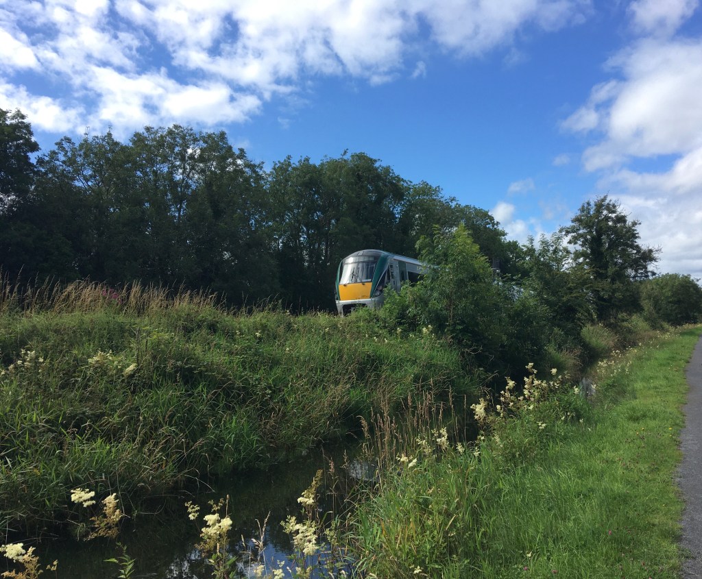
Irish Rail Intercity running alongside the Feeder
About 650m from the Graveyard we come to a small accommodation bridge as the Feeder takes a slightly more curved route than the direct rail farm. Accommodation bridges were built by the canal company to give access to both sides of the canal for landowners and farmers whose land had been bisected by the construction of the canal.
Feeder looking north from the accommodation bridge
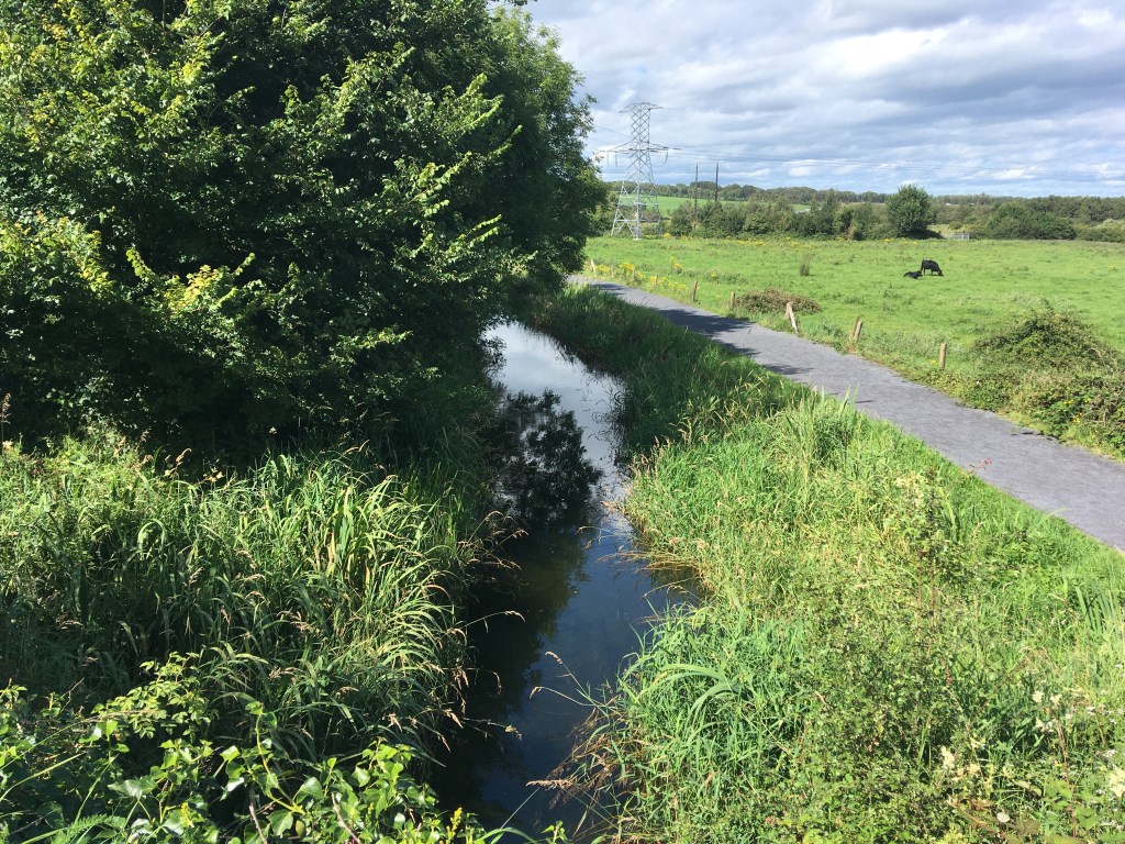
When the Feeder and path meet back up again we can see Cullion Fish Farm. Featured in Waterways: The Royal Canal the fish farm which specialised in Trout was slated for closure in 2016, however it still seems active when I passed it in July of 2020.
Cullion Fish Farm viewed from the Feeder path
According to the Guide to the Royal Canal the fish farm is fed from the feeder through a metering apparatus via a culvert under the path which abstracts water from Lough Owel.
Culvert and metering apparatus from the Feeder to the fish farm
Just past the fish farm we come to Cullion Bridge. It is necessary to leave the feeder path here for about 500m to carry on towards the lake.
Cullion Bridge
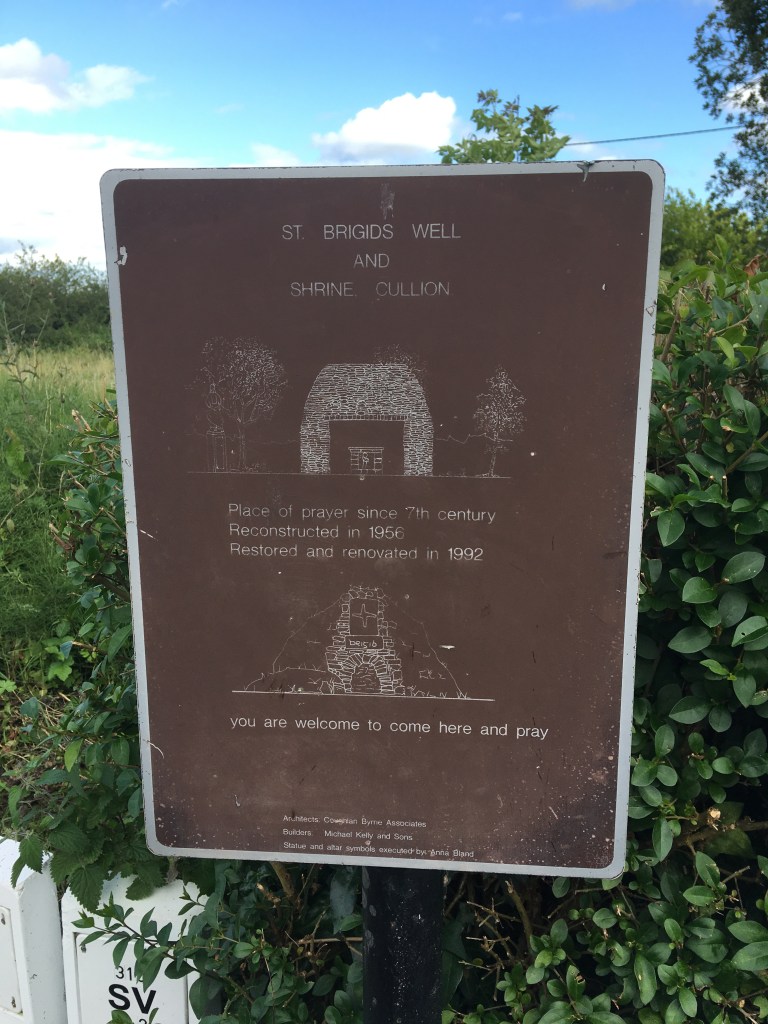
As we pass through the gates at the Cullion Bridge you will notice a sign for St. Brigid’s Well to the right just beyond the gate for the fish farm. The small well with the stations of the cross is a peaceful place for reflection and worth dropping into as you pass.
Sign for St. Brigid’s Well
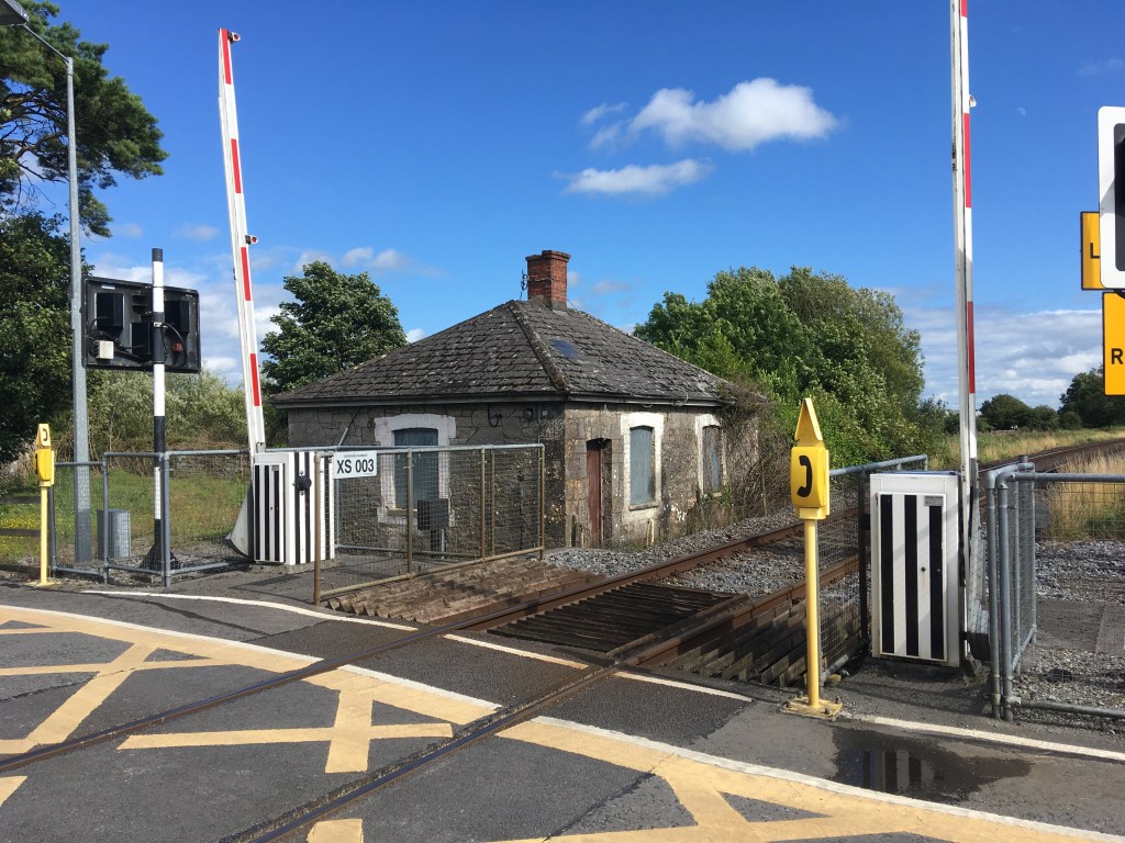
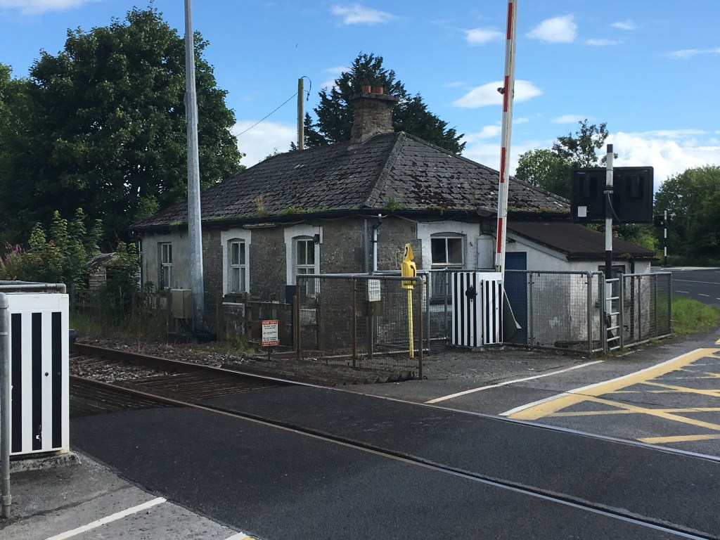
Crossing over Cullion Bridge will bring you past Culleenmore Level Crossing Gates and the Gate Keeper’s Cottage there. Crossing the old Longford Road you will signs for a cycle way which will bring you on towards the lough and return you to the Feeder path.
Culleenmore Level Crossing and Gate Keeper’s Cottage
Levington Railway Crossing and Gate Keeper’s Cottage
Rounding the corner of the cycle way you will come to Levington Railway Crossing Gates and Gate Keeper’s Cottage and just before the crossing you will see a sign for Mullingar Sailing Club on the left which will lead you back down along the Feeder to Lough Owel.
Lane on the left to Mullingar Sailing Club & Lough Owel
Following the lane for 200m the Feeder is on your right until you come to a small bridge which brings you back across the Feeder for the final stretch down to Lough Owel.
Bridge over Feeder near Mullingar Sailing Club.
Once over the bridge it is only a little over 400m to Lough Owel. When you get to the lough and Mullingar Sailing Club you will see a small gate and a white house on the left. This is the Sluice House where the flow of the water to the canal was controlled.
Front of the Sluice House with Bridge and Arch over the Feeder on the right
Behind the house on the lake side is the main sluice gate itself.
Main Sluice Gate at the rear of the house. Note the left gate is down but the right gate is up
After the Sluice House you have reached Lough Owel and the original source of much of the Royal Canal’s water. Although an often forgotten part of the Royal Canal, the quality path makes this a pleasurable diversion worth taking when passing Mullingar.
Given how intertwined the history is between the Royal Canal and the Midlands Great Western Railway (MGWR) I think it would be remiss of me not to put up a post about the old MGWR Mullingar to Athlone railway line which has been converted into an amazing 40km greenway called the Old Rail Trail which is entirely in Westmeath.
Image of the Midland Great Western Railway Company Crest from the Model Railway Museum in Malahide
I previously discussed running the Old Rail Trail from Athlone to Mullingar here but in the context of my series of guide posts of the Royal Canal I will revisit the topic here starting in Mullingar. A quick history lesson will tell you that the MGWR was incorporated in 1845 and at its peak was the third largest railway company in Ireland after Great Southern & Western Railway (GS&WR) and Great Northern Railway of Ireland (GNR). The MGWR bought the Royal Canal with the aim to build a railway to Mullingar and onward to Longford. Construction of the railway began in January 1846 and reached Mullingar in 1848.
Plaque marking the 150th Anniversary of the opening of Mullingar Railway Station
There was a rivalry between the MGWR and the GS&WR to reach Galway first and so it was that the MGWR extended their line from Mullingar to Athlone and onward to Galway, capable of running trains from Dublin to Galway from August 1851. It would be another 8 years before GS&WR reached Athlone and from that point on used the already laid MGWR line west.
Starting at Mullingar Railway Station, the platforms and shelters of the old Athlone line are no longer in use or accessible. They sit around the far side of the station building and can only be viewed from inside. Also visible from the station building is the Signal Box on the Dublin side which commands view of both the Athlone and Sligo lines as they part either side of the station. The Athlone line through the station is still in place as far out as the railway sheds and workers terrace passing over a bridge immediately after the station. These sheds were used by the Railway Preservation Society of Ireland in the restoration of Great Southern & Western Railway Locomotive No. 184. This locomotive went on to be used in the filming of The First Great Train Robbery starring Sean Connery and Donald Sunderland where many moving scenes were shot on the Mulligar to Athlone railway line. No. 184 is on display at Whitehead Railway Museum in Co. Antrim. There is also the remains of a turntable out by the railway sheds. The workers terrace was also the location of a true crime in 1869 when it was reported that the then Station Master Thomas Anketell was shot and murdered and a newspaper article about the incident can be found here.
Old Rail Trail map near Grange Bridge
Unfortunately while we can view the sheds from a distance or on Google Maps we are unable to go directly by them so to access the start of the Old Rail Trail it is best to exit the station onto the Royal Canal Greenway and head west as far as Grange Bridge which was described by the late Dick Warner as like having the legs of a Mullingar heifer. Alternatively there is an Old Rail Trail car park adjacent to Grange Bridge on the south side of the canal.
Grange Bridge looking east.
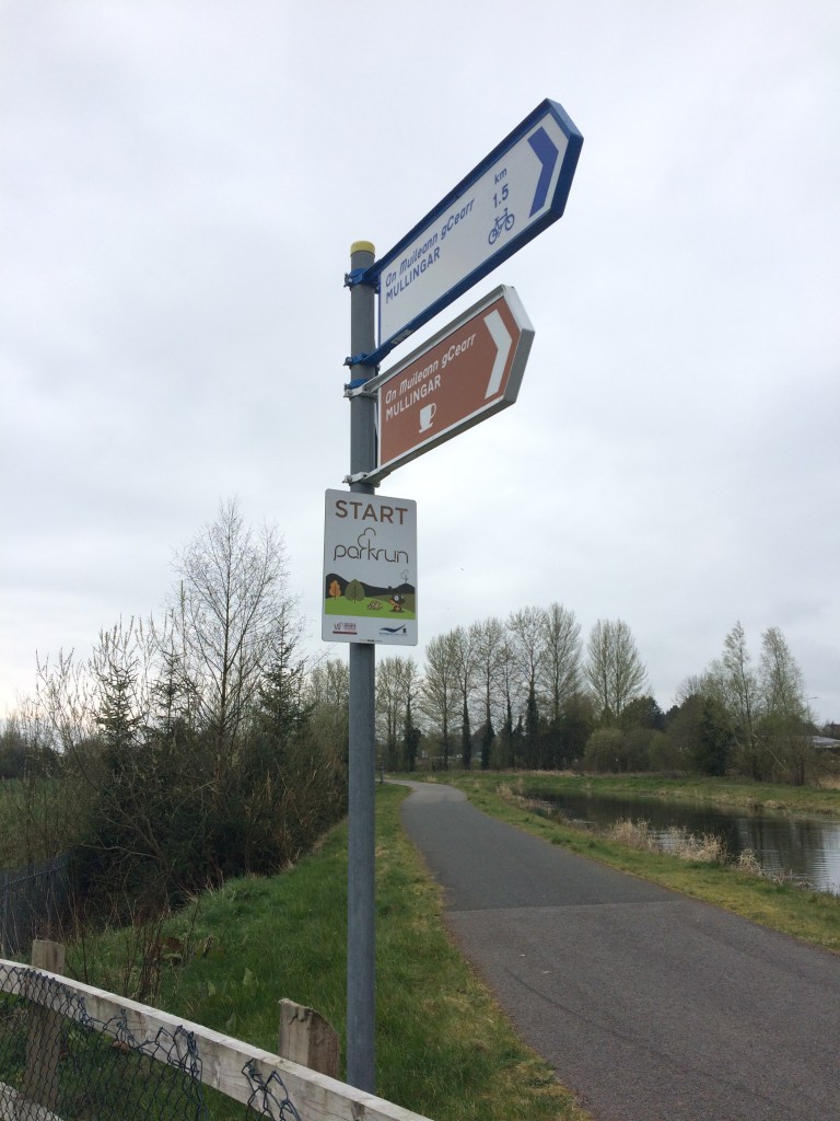
Just after passing Grange Bridge you will see that the Royal Canal Greenway splits in two. On the right you stay with the canal and the route as far as Coolnahay is described in my post here and on the left is the start of the Old Rail Trail. You will also see the start sign of Mullingar parkrun at the Y of the two greenways.
Mullingar parkun Start sign at the split between the Royal Canal Greenway and the Old Rail Trail
As you start moving west on the Old Rail Trail you will notice it is a smooth tarmac surface unlike the dust stone used on the Royal Canal Greenway. This tarmac surface is used the whole way to Athlone and as such makes it the perfect surface for a smooth cycle. Passing the industrial estate on the left you will notice the remains of a railway platform which was used to serve the Mullingar Racecourse at Newbrook. From what I can gather from Railscot’s record of Irish Stations the platforms operated from 1902 to 1962.
Signal Cable Pole along the trail
The Royal Canal Greenway and the Old Rail Trail run parallel to each other for roughly 3.5km from Grange Bridge out to Ballinea. The parkrun course is made up of an out on the canal and a return on the Old Rail Trail. Close to Kilpatrick Bridge over the canal there is also a squared off bridge over the trail.
The high wall at the road bridge over the trail at Kilpatrick
Not far beyond Kilpatrick Bridge we come to the last link to the Royal Canal Greenway where the parkrun turns to go back to its finish. Just beyond that is also the last MGWR bridge that is abutted to an older Royal Canal bridge at Belmont Bridge. There is a small shop in Ballinea which you can get to by taking the Royal Canal here. If you haven’t come with supplies I would suggest taking the time to stop here and get something as Moate is the next location where you really have an opportunity to get anything.
Looking towards Mullingar at Belmont Railway Bridge
As can be seen in the above photo, the Old Rail Trail only takes up about half the surface available to it as it was once a double line track and as a result there is the remains of one of the tracks for the majority of the distance to Athlone to remind us of the proud rail heritage that the trail is built on.
Old Railway Signal near Castletown
At Ballinea we pass a private residence that was most likely originally built as railway workers cottage. We have left the old world of the canal now, the familiar sights of Locks, Keeper’s Cottages and humpback bridges are replaced with the railways own take on engineering with workers cottages, stations, water towers and sheds all to come.
Short tunnel just west of Ballinea
Not far west of Ballinea we pass through the closest thing to a tunnel the Old Rail Trail has. As we move further west in what is nearly a straight line we both go over and under many bridges alternating between the roads going over and under the railway. Unless they have some key relevance though I will only mention the bridges we pass under as it is near impossible to take a worthwhile photo of a bridge when standing on top of it.
It is interesting as we move across the landscape how the railway would have cut through the land in places like at Barrettstown where high walls flank us on either side to soaring high above the farmland at other points affording us views as far as the eye can see, not to mention a wind that can cut you on a cold day so a reminder to always be prepared.
3.5km from Barrettstown we come to what was Castletown Station which was open from 1851 until 1987. The first thing to greet us is the magnificently restored signal box. Behind the signal box is Ard Na Greine, a Victorian house and former dispensary. Crossing over the road we come to the station and its platforms.
A dark eerie image of the remains of the Gate Keeper’s Cottage at Castletown.
The Castletown Station is now a private residence on the northern platform but the southern platform does offer picnic benches for those passing by. As mentioned previously it is important to bring your own supplies on this trip, however, Castletown Geoghegan has a shop in it 2km south along the road if you need it.
Castletown Station in the left with the Signal Box in the background.
Though boarded up the remains of a platform waiting room faces the station on the southern platform and to complete the station set there is the remains of a goods shed just west of the platforms as you are leaving.
Castletoewn Goods Shed
Leaving Castletown behind us we head towards an area known as Killeen and the area around Jamestown Court, with its Gate Lodge adjacent to the bridge over the railway which acts an entrance into the estate and its folly. Unfortunately the splendour of Jamestown Court cannot be seen from the Old Rail Trail as it is cut into the land below it.
Bridge at Killeen near Jamestown Court
Just short of 4km from Jamestown Court we come to Streamstown Junction and its old station which opened in 1851 and closed in 1963. MGWR had a railway from Streamstown linking to the GS&WR at Clara via Horseleap. Horseleap was open from 1876 to 1947 with the line permanently closing in 1965. The MGWR station in Clara operated from 1866 to 1925 but what was the GS&WR station is still open on the line between Tullamore and Athlone.
Streamstown Station (under renovation?)
Streamstown is located nearly half way along the Old Rail Trail, 17km from Mullingar and 23km to Athlone. The last time I passed (April 2019) there was an open air museum dedicated to old farm machinery on the northern platform.
Some of the farm machinery on the northern platform
The station building itself was also covered in scaffolding. I have heard rumours that it was being done with the intention of opening a cafe in it. This would be a fantastic point along the route for one but I have no definite source for such a comment so only time will tell. The work may just be preservation work. The station also has the remains of a few other buildings including a small goods shed and a waiting room.
Waiting Room at Streamstown Station.
Apart from the obvious railway and buildings along the route, many other things associated with the railway also remain. These include mile markers, signals and cable polls.
Mile Marker 65 3/4. The shape of the marker indicates if it was a full, 1/4, 1/2 or 3/4 mile. A square being a full mile, a square turned 45 degrees a 1/4 mile, triangle being a half mile and the above ‘V’ being 3/4 mile.
At certain points along the trail you cross over older bridges that once carried the railway over the road below but have not endured the test of time as well as others. Not far past Streamstown is one such example where the trail narrows slightly where the old bridge that once carried two lines has been fixed up just to safely carry the trail.
View of an old bridge that has been repaired and modified to carry the trail
Not all the bridges we come to are built of the familiar limestone that we are used to along the canal. The next bridge up at Derryhall has a heavy metal work span over the trail, crossing at an angle rather than straight on.
It is an 11km stretch of open countryside between Streamstown and Moate and while it would be wrong to say it is flat, saying it is made up of rolling hills would not be fair either. Exposed at times, this rural area is quite a pleasant place to transit through dotted with little more than farmhouses, sheds and bridges.
Not too far after passing under the bridge at Grange we come to the largest urban settlement along the Old Rail Trail, the town of Moate.
Plaque marking the opening of the Athlone to Mullingar Cycleway at Moate Station in 2015
Moate railway station opened in 1851 and closed in 1987. Like Castletown there are a large number of railway associated buildings and structures remaining as we pass through the station between the old platforms.
Moate is a great little town to stop off in and get some lunch with plenty on offer to suit all tastes and budgets. Right beside the train station you will see signs pointing you to the Moate Golf Course Restaurant. If you rather venture into the town a little you will find the coffee shop at the Tuar Ard Arts Centre and of course you can never go wrong with at curry cheese chips at Supermacs. There is also a Centra and a SuperValu not far from the station for whatever supplies you may need.
Old Rail Trail Distance Signs at Moate
Leaving Moate behind us we only have another 12km to go to get us to Athlone. Not far from the station and still withing the town limits we come to Jones Crossing where the old Gate Keeper’s Cottage is now a private residence and the crossing gates are still in place.
Gates at Jone’s Crossing
Further west again we come to another level crossing at Magheramore where once again the Gate Keeper’s Cottage has been retained as a private residence.
Gate Keeper’s Cottage at Magheramore
The section between Moate and Athlone is very people with the residents of both towns to get out and get some exercise in both directions. There is a car park located for Greenway users at Tully Bridge about half way between the two towns.
Car park and access at Tully
You are met on the outskirts of Athlone by the bridge carrying the N6 over the Old Rail Trail on its way to Galway from Dublin, the modern passing over the old, the rushed passing over the leisurely.
N6 Bridge east of Athlone
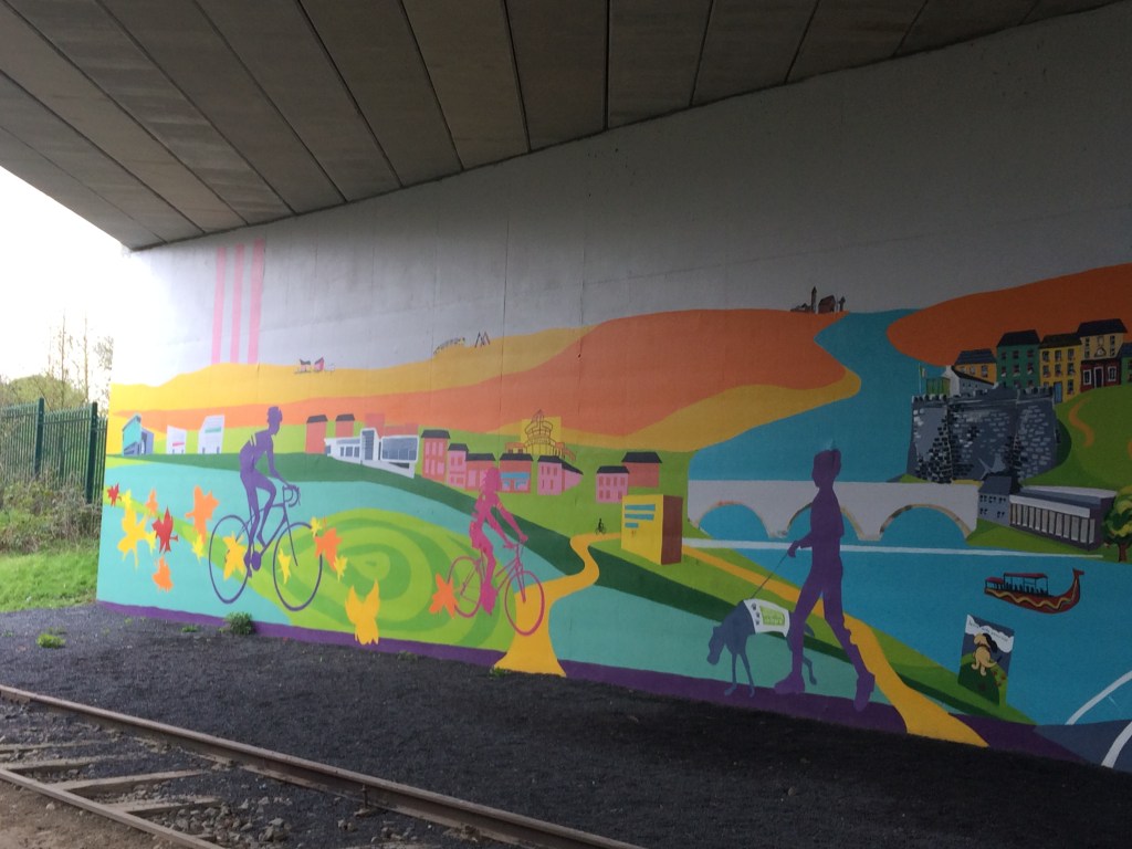
Much more welcoming than the N6 Bridge is the bridge a little further up at Garrycastle near Athlone I.T. with its colourful murals.
The murals at Garrycastle
There is a large Spar with a car park just off the Old Rail Trail at Garrycastle offering another good place to fuel up and it includes a reasonable deli and a place to sit down to eat. The trail is has lighting from here the whole way into Athlone town and will probably be the busiest section you will come to. It is only 2km from here to our end point at the White Gates.
Old Garrycastle Bridge with the new one behind it.
We pass Athlone GAA Club as we reach our destination at the White Gates after travelling the 40km from Grange Bridge at Mullingar. For the runners among you, add in the distance to Mullingar railway station and you will be looking a a nice marathon distance.
White Gates Athlone
When I did this journey last the White Gates marked the start/end of the Old Rail Trail but the plan is that this will continue on from here the whole way to Galway to make up the Dublin – Galway Cycleway. Westmeath County Council are certainly to be commended for having their part already done.
Given I started at the MGWR railway station in Mullingar I think it is only right that I should mention the old MGWR railway station in Athlone. Only 600metres from the White Gates the old MGWR railway was joined by it the GS&WR railway coming from Hueston where crossed the Shannon together on the Shannon Railway Bridge before the MGWR Railway Station on the west bank of the river. The old station now serves as Irish Rail offices and stores while the GS&WR Railway Station on the east bank is the passenger station for Athlone. From there locomotives from both companies steamed west to Galway.
My posts about the Royal Canal Greenway can be linked to below:
Running the length of the Royal Canal in a single day is a fairly unique way to experience the joys of travelling along its banks. However, a promise I made to myself that mid-summers day in 2019 was that one day I would return to see the canal the way it is truly meant to be seen, to be experienced, from the water. It took me over two years to finally book a trip with Royal Canal Boat Trips and the charismatic skipper Jenny.
Jenny and her barge passing the Maynooth Swans and cygnets
2021 has certainly been the year of the Royal Canal. While the navigation itself fully reopened in 2010, 2021 has seen the launch of the Royal Canal Greenway, Ireland’s longest greenway, linking Maynooth to the Shannon at Cloondara with options to also travel the Old Rail Trail to Athlone or take the Longford Branch off the main line to Longford town. Following on from the launch of the greenway, RTÉ’s Nationwide also dedicated a weeks worth of their programming to exploring the canal with hosts Anne Cassin and Bláthnaid Ní Chofaigh starting at opposite ends and meeting each other in Mullingar.
While the Greenway has been getting the majority of the focus of late, the setting for my short cruise is the marvelous Deep Sinking, casting off from the 12th Lock in Castleknock and heading west through a true man made wonderland, largely untouched by development since its difficult and costly construction in the 1790’s.
I have already covered the Deep Sinking from the towpath on my page here but I think it is fair to say it is an area like no other on the Royal Canal for intrigue, controversy, expense and tragedy, all of which take on a much greater meaning when seen from the water rather than from the heights above.
Magical Reflections from the water of the Deep Sinking
Let me first start with the intrigue. Why was it that over 200 years ago the board of the original Royal Canal Company decided to deviate away from the surveys that told them that it would be more practical and cost effective to build the canal on a more northerly route rather than to dig and blast their way through a limestone quarry? As knowledge of history of the Royal Canal grows, many would now tell you that this was done at the behest of the William Fitzgerald, 2nd Duke of Leinster, a subscriber to the Royal Canal Company, so that the canal would pass alongside his country seat of Carton House, now a luxury hotel and golf course.
Unfortunately with all the records of the original Royal Canal Company lost, it is not something I think we can ever be 100% sure of. That said the Deep Sinking was a mammoth undertaking in terms of cost and labour, taking several years to dig out of the hard rock. Fast forward to today and considerable attention has been drawn to the existence of 4 arches built into the south bank of the Deep Sinking between Kirkpatrick and Keenan Bridges. Awareness of these arches has gained traction through the Friends of the Deep Sinking Facebook group while their true function remains a mystery. My own personal thinking is that they were build to provide stability to weak parts of the towpath where the horses would have once pulled the barges through the Deep Sinking from a considerable height above the canal.
Arch hidden by overgrowth as seen from the barge
As Jenny navigates her daily charter back and forth along the Deep Sinking she has well established the location of the 4 arches. While I know exactly where 2 are from the towpath and have been down in both, one of them is definitely inaccessible from land and I think it was with sense of glee and adventure that she waited patiently to unveil another arch to the world from its mask and curtain of thorny overgrowth. As she stopped the barge alongside the arch pointing out its keystone and light coming through from the other side, it didn’t take any encouragement for me to clamber up the bank and see it from the inside.
Looking back at skipper Jenny and my wife from the arch
Of course now that I made my way up here, it was time to document what I found. The most startling object that caught my attention first was an old motorcycle helmet, lord knows how long that has been down there.
A motorcycle helmet found in the arch
So while I had a sense of adventure, it would seem I am not the only one to have been down here in recent years despite how inaccessible I think the place is. The arch itself is built of brick and is the width of the towpath it carries above.
Several bricks are missing and it can be seen how the arch is built into the bedrock below it.
Vegetation from above has caused some damage as roots have spread over years and a large root now sprouts out of canal facing side of the arch having forced some bricks free and splitting others around it.
Roots protruding out through the brickwork near the centre of the arch
Of course a structure like this is not something that should be kept secret or hidden, especially if we are to have any hope of it being preserved given its delicate condition. Jenny came prepared and passed me up a set of pincer shears which I was able to use to remove some of the curtain, allowing light flow in from the canal side so that passers-by on the canal can marvel at another wonder of the Deep Sinking.
The arch after its haircut, opened up for all to see
After getting my feet firmly back on the barge, we proceeded gently west again, stopping a short distance further at the site of an old well just before Keenan Bridge. While the well was dry you could see how steps had been fashioned down to it from the towpath and how a pipe had been installed so water could be taken from the well. It gave me an amazing sense of joy to be shown these things that I knew nothing of before, highlighting that no matter how often you pass through a place, there are always little treasures and secrets to find.
Well on the south back with small pipe at its base
It is at Keenan Bridge that we come to the tragedy I mentioned earlier. Sensitive souls can feel an eerie feeling of loss passing through the bridge, not far from where the sinking of the Longford passenger boat, with the loss of 16 lives happened in 1845. A better account than I can offer can be read on the Irish Waterways History website. A memorial plaque was erected by the Royal Canal Amenity Group on the bridge on the 150th anniversary in 1995.
Keenan Bridge as viewed from the Clonsilla side near the location of the sinking of the Longford passenger boat
From Keenan Bridge we headed for our turn around point just short of Callaghan Bridge at Clonsilla Train Station, a distance of 2.5 miles in about 90 minutes. This is the true pleasure of travelling by barge. When running I would expect to cover 9 miles in 90 minutes and would still think that I have taken in my surroundings but in reality I have missed so much and have a whole new appreciation for the Deep Sinking by taking the time to travel its waterway and conversing with those who have a shared love of the canal, its history and its heritage, each of us filling in a little bit of the rich tapestry that makes up the fascinating tale of its past and those who have gone before us, be they navvies, engineers, merchants or travellers.
Approaching the turn around point near Callaghan Bridge
I mentioned earlier that the Deep Sinking was also the site of controversy and expense. This started indeed with its construction in the 1790s and between making the Deep Sinking navigable and building the Rye Water Aqueduct in Leixlip, the Royal Canal Company had drained its financial resources barely getting out of Dublin, let alone making it to the Shannon. What followed was protracted funding requests to government allowing the canal be finished first to Kilcock in 1796, eventually on to Mullingar in 1806 before the company fell bankrupt after reaching Coolnahay around 1813. From there the canal was finished to the Shannon under the control of the Directors for Inland Navigation, finally being completed to Richmond Harbour in 1817.
The canopy above the Deep Sinking on a soft day
It seems this controversy continues on into the 21st century with the planning for the completion of the Greenway into Dublin from Maynooth and the intention of developers to build apartments very close to the canal bank. I cannot deny that I am an advocate for the completion of the Greenway and I hope that a solution that allows that completion can be found, however I am very mindful that the Deep Sinking is a place steeped in wildlife, built heritage and also a spiritual resting place. All these factors must be considered in advance of any work undertaken. The canal is man-made, built over 200 years ago and while it needed substantial work to restore it for navigation, the craftsmanship on display shows it was built not only to outlast those who started it, but the many generations that would follow in its wake from a commercial route to a leisure amenity.
Kirkpatrick Bridge built into the bedrock of the Deep Sinking with tool marks visible
The short trip only heightened my desire to one day travel the full length of the canal once again, only this time at an easy pace, by barge, all the best explorers went by boat right? I will take it one step at a time though, the next step is to see if I can book another trip with Royal Canal Boat Trips as far as Maynooth and get to experience transiting through a lock. After our return to Castleknock my wife and I were a little early for lunch in the 12th Lock so we walked on along the canal to The Lock Keeper at the 10th Lock in Ashtown.
Finished the day with lunch at the Lock Keeper in Ashtown
PS – Many thanks to my wife Niamh for many of the photos used here, recording what I was only taking in in my own minds eye as the skipper and I shared stories of travelling the canal.
With the Dublin Marathon being held virtually for another year, Leixlip man Declan Kenny has organised a self supported marathon along the banks of the Royal Canal from the Hill of Down to Leixlip Confey which people can use to record a virtual Dublin City Marathon time on the DCM app or for people who just want to do a distance event in great surroundings. Details about signing up for the Down to Town Marathon can be found here. For those of you signed up, I hope you will find this post a useful guide to the route on the day along with the photos I have taken to help give you visual reference points along the way.
Race Organiser Declan Kenny wearing the event Buff
As Down to Town is a point-to-point marathon, the meet up point is at the finish area at the Confey GAA Club at the top of Captains Hill in Leixlip. Please note this is not the same as Leixlip GAA club which is on Green Lane. From there participants will take a bus departing at 9am to Hill of Down for a start time of 10am. In order to make up the correct distance, the start line is roughly 450 meters west of drop off point at Killyon Bridge which the participants will have to walk to. This will give you a good opportunity to warm up.
The tree on the south bank that marks the start line.
View looking east towards Hill of Down from the start line.
The marathon starts on the north bank of the Royal Canal Greenway (canal is on your right hand side) and it is a short distance of 450m to the first landmark we will come to, Killyon Bridge in the village of Hill of Down. Approaching the bridge, the path splits in two, one leading under the bridge and the other leading over it. The path under the bridge is narrow and caution is required but is still the better option as going over the bridge to the other side requires crossing a main road.
Approach to Killyon Bridge, Hill of Down. Runners can use the narrow path on the right to pass under the bridge.
Leaving Hill of Down, it is 2.5km to the next major landmark, Blackshade Bridge. It is not possible to pass under the bridge so it is necessary for runners to run up a slope to the bridge and cross a main road before carrying on down on the other side, all the while remaining on the north bank of the canal.
Rising up to the main road crossing at Blackshade Bridge
After dropping down the other side of Blackshade Bridge it is a little over 2km before we come to the River Boyne Aqueduct which lies just to the west of Longwood Harbour.
Approaching River Boyne Aqueduct
After passing over the River Boyne and the Longwood Road Aqueduct you will come into Longwood Harbour. As this is a self-sufficient marathon it is useful to know that there is a tap on the edge of the old cottage building in the harbour. There is also usually a horse-box coffee shop at the harbour should anyone want to get supplies early on. I will point out several places where supplies can be purchased close to the route as I go along. Unfortunately I cannot be certain that all of these will be open/working on the day.
Longwood Harbour with Horsebox Coffee Shop. Note small black box to the right of the Red Cottage door which has a water tap.
Next up, leaving Longwood Harbour behind us, we come to the Ribbontail Footbridge and stop gates. These are just short of 2km beyond Longwood Harbour.
Ribbontail Footbridge and Stop Gates
A further 2km east we come to Furey’s pub in Moyvalley and the first place we must cross over the canal to the south bank where the canal will now be on the runners left. Ascending up towards Furey’s Pub and Moyvalley Bridge, you will be on the old Galway road as you cross the canal bridge before descending down the ramp under the new Galway Road and continuing on the south bank.
Ascending up to road level between Furey’s Pub and the old Moyvalley Bridge
Runners must cross the bridge carrying the old road to the south bank of the canal.
Once over the bridge you descend down the new ramp on the other side of the canal.
Not long after coming down the ramp you will pass the 10k marker for the marathon as you run along a green fence that separates the Greenway from the Railway.
Approaching the 10K marker for the marathon just after Moyvalley
Just under 2km from Furey’s you will come to Kilmore Bridge. Like Killyon Bridge in Hill of Down, runners have the option to take the narrow path under the bridge or to rise up over it having to cross the road while doing so. There is a guard rail under this bridge so it is best to carry on under.
Approach to Kilmore Bridge where runners can pass under the bridge rather than having to cross the road over it.
Less than 1km after Kilmore Bridge, runners will pass over the Blackwater Aqueduct.
Crossing over the Blackwater Aqueduct
Runners have a good straight run of 3.7km after the Blackwater Aqueduct to the next landmark of Enfield Bridge and the next crossing point of the canal. This is one of two major road crossing on the route that have pedestrian traffic lights. When you come up to the bridge it is worth knowing there is an Applegreen Service station about 100 meters to the right before crossing the road if you need any water or supplies. The pedestrian lights are very responsive to those using the canal so I recommend using the lights to cross the road which will also bring you back down on the north bank of the canal (canal is on your right hand side) which is the side you will stay on for the rest of the marathon.
Approach to Enfield Bridge
Applegreen Garage with Shop 100m from Enfield Bridge on the right.
Pedestrian Lights and Crossing on Enfield Bridge. Runners must cross over the road and the canal to the north bank to continue.
Dropping down the other side of Enfield Bridge with the canal now back on the right hand side of the Greenway path.
Leaving Enfield behind we run for just over 2km before we reached a shared road space where cars may be driving along the same section of canal as we are running.
Approaching the gate to the shared space road to Cloncurry Bridge
Shared space road heading towards Cloncurry Bridge
The road lasts for just less than 1km before we reach Cloncurry Bridge. Unfortunately we cannot pass under Cloncurry Bridge so please exercise caution as you rise up over it, across the road and down the other side. Any of you who are familiar with Lock Up the Year marathon may remember having to cross over the bridge here. This is no longer necessary, the Greenway continues on the north bank so please stick to the good surface and avoid the muddy trails of the south bank (unless that’s really your thing).
Approach up to Cloncurry Bridge
Be careful crossing the road and carry on down the otherside.
There are a few houses down the road on the other side of Cloncurry Bridge so be mindful you may have a car or two pass you along this section but it is unlikely. 2km on from Cloncurry Bridge you will reach a farm house with a pair of gates to the right. These gates are closer together than any of the gates we have gone through so far, reduce your speed as you pass through them.
Tight squeeze of gates beside farmhouse
Not long after passing through the gates you will reach the half way mark for the marathon before reaching the forest section.
Tree marking the halfway point of the marathon.
It is roughly 3.5km to the next landmark of the 17th Lock, known locally as Ferrans Lock. You have spent nearly 24km on the Long Level before reaching the 17th Lock which marks the start of the descent down into Leixlip. As we approach the 17th Lock you will see a gate off the road and the Greenway rises to the lock on the right before dropping down again, crossing the road at the railway crossing to carry on towards Kilcock.
Keep right when you meet the road as you approach the 17th Lock.
The drop down to the road at the 17th lock, caution when crossing the road.
Pass through the metal gate to carry on towards Kilcock
After crossing the road at the 17th Lock it is just short of 3km to the next landmark of Allen Bridge, also known locally as Spins Bridge. This part of the route may be familiar to those of you who have done Royal Canal parkrun Kilcock. The path under Allen Bridge is fairly tight and this can be a busy section of Greenway so it may be useful to shout ahead as you approach encase you bump into somebody coming in the other direction.
Approach to Allen Bridge.
Coming out the other side of Allen Bridge, be aware that a path joins from the left as you emerge.
It is 1km from Allen Bridge to the 16th Lock and Shaw’s Bridge and the upper end of Kilcock Harbour. Dropping down by the 16th Lock you come to the second major road crossing of the route which have pedestrian lights. Unfortunately these lights are less responsive than those in Enfield so be prepared for a wait to get a green man to cross. There is a Supervalu in Kilcock to the left off the bridge if you really need any supplies at this point however it does require a diversion of 250 meters to get to the shop and another 250 meters to get back to the canal. Alternatively there is a Lidl just across the road on the edge of the town as you pass. The harbour in Kilcock also has several bins so is the first real opportunity to dispose of any rubbish you may have.
Dropping down to the pedestrian crossing at the 16th Lock in Kilcock.
Pedestrian Lights at Shaw’s Bridge, Kilcock Harbour.
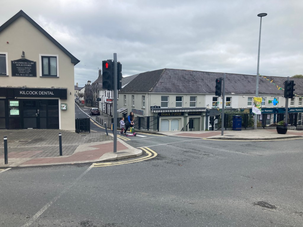
If you take the road here between Kilcock Dental and the Black Forest Cafe, Supervalu is 250 meters straigh ahead.
Less than 2km east of Kilcock you will come to Chambers Bridge at the 15th Lock. There is a double set of gates here and while it is unlikely that any cars will be moving around the bridge, the local residents can be coming or going so just keep an eye out.
Approaching the first gates at Chambers Bridge and the 15th Lock.
Approach to Chambers Bridge and the local access road on the left.
Once past Chambers Bridge you are running alongside the grounds of North Kildare Club. As you are passing you are likely to see an open gate to a small shipping container that is usually open selling snacks, coffees and soft drinks and may be a useful place to have a quick pit stop if you need an energy boost. As mentioned before I cannot be 100% certain it will be open on the day but at time of writing it usually is on a Sunday morning.
Gate into North Kildare Club with small coffee stand beside the canal.
You will notice that from the 17th Lock on, there tends to be more traffic along the Greenway from walkers to runners and cyclists so please be mindful and respectful of other users of the Greenway. A short distance after North Kildare Club you will pass under Bailey Bridge which now has a large concrete extension to cater for Greenway users but can have a bit of a blind spot for those coming in the other direction.
Approach to Bailey Bridge which as you can see is difficult to see people coming towards you from the other side.
It is slightly less than 1.5km from Bailey Bridge to Jackson Bridge and the 14th Lock which marks the 32km of the marathon or more importantly, only 10km left to go. There is a low narrow pedestrian arch in Jacksons Bridge which can also be blind to people coming from below the lock so be cautious on approach.
Approaching the 14th Lock at Jacksons Bridge, 10km to go.
Narrow, low pedestrian arch at Jackson Bridge
After passing under Jackson Bridge you are running alongside the edge of Maynooth College and after nearly 2km you will come to Bond Bridge as you come into Maynooth. Like Allen Bridge, Bond Bridge is narrow and can be blind passing under it.
Approach to Bond Bridge
Out the other side of Bond Bridge you are on the last of the official Greenway section of the Royal Canal as you approach Maynooth Harbour 500 meters further on from the Bridge.
Approaching Maynooth Harbour
Maynooth Harbour is triangular in shape and requires you to run slightly towards the town and the harbour slipway before carrying on past the the playground towards Mullen Bridge. As you reach the slipway you will see the Harbour Field. If you look across the field you will see a set of traffic lights on the far corner, beyond which lies a newsagents and Supervalu in the Glenroyal complex should you want any supplies. If you do leave the course here it is possible to rejoin the canal by running up the ramp beside the hotel which will then drop you down the other side of Mullen Bridge. Like almost all the bridges we have encountered, when coming from the harbour, exercise caution as you pass under the bridge as the path us narrow. You will also pass under the ‘new’ road bridge.
Approach to Mullen Bridge
Passing under Mullen Bridge and the Straffan Road Bridge
Ramp up from Supervalu Maynooth to Mullen Bridge
As I mentioned earlier, the Royal Canal Greenway ends at Maynooth Harbour so the towpath isn’t as good from here on to the finish. That said it still have a stone surface from Maynooth Harbour to Pike Bridge and a little beyond which is over 2.5km before you reach a grass section. Some of the section can have large puddles though if it is wet.
Approach to Pike Bridge outside Carton House.
Passing under Pike Bridge to Carton Wharf
A little after Carton Wharf at Pike Bridge we come onto the softest section of the course which lasts for about 1km to Deey Bridge.
Trail section of Towpath approaching Deey Bridge and the 13th Lock
As we get to the 13th Lock, we cross over a quiet road, however we must make our way through a set of kissing gates before crossing the road. The good news however is that we are back on solid ground for a bit on the other side.
Approaching the Kissing Gates and road at Deey Bridge and the 13th Lock
Crossing the road and the narrow gate the other side of Deey Bridge.
You are now running past Intel and Le Chéile Running Club as you approach Louisa Bridge, 1.5km beyond Deey Bridge. Again Louisa Bridge has a narrow approach and is blind to the other side.
Approaching Louisa Bridge.
Emerging out the other side of Louisa Bridge.
You are now on the final stretch of the Down to Town Marathon as you make your way across the Ryewater Aqueduct and past the Old Toll House.
The Old Toll House.
You round one last corner before having less than 1km straight to the finish line.
The finish line awaits you just short of Cope Bridge at Confey
When you finally reach the finish line, it is just a short hop across the road to Confey GAA where we all gathered at the start to grab the bus.
Confey GAA Club from the Canal.
One final thing I have to add, you will see several portaloos along the route behind fencing. Unfortunately these are not for public use and are locked so they may as well be a mirage or an hallucination for all they are worth. Sadly, a few that had been put in recently for public use have already been burnt out.
One of several inaccessible portaloos along the route.
I hope you have found this guide useful and I look forward to running with you on the day. – Gary aka the Royal Canal Runner.
After nearly a year of planning and 35 weeks of training the evening of the 20thof June had arrived, my crew had been briefed, my kit bags and supplies packed and repacked and all the relay runners who would accompany me along the 90 mile journey knew where and roughly when to meet. It was time to head in to the start.
All packed and ready to go
My wife Niamh who would be primarily looking after me throughout the run got into our car at our home and we made the half hour journey into Connolly Station car park. Colin, who was my well briefed crewman looking after the logistics of the relay runners was joined at the house by Paul, one of the first relay runners and they would pick up John on their way before joining us in town.
Going over the check list with Paul
The meeting point was 22:30 in the main concourse of Connolly Train Station. It was the last opportunity for some of us to use a toilet before heading out. Several of us met there before proceeding down to the Lifting Bridges at the Sea Lock where the Royal Canal meets the River Liffey at North Wall Quay.
With family before the start
It was very encouraging for me to see so many supporters here to see me off. Family and friends had gathered to wish me luck before we set off. We posed for photos, many of us wearing the event t-shirts which were printed up by Ash and his team in Run Logic.
With Ash from Run Logic who printed the t-shirts
The plan was to start bang on midnight when my Garmin FR235 hit 00:00. Given it was dark and we were in the city centre I had planned a long time ago that it would be wise to have a large contingent of runners with me to escort me out of Dublin City Centre and its environs and continue with me into Co. Kildare.
L-R Standing: Colin, Niamh, Dave, Paddy, Paul, Ros L-R Front: JC, Gary (me), Ross, John
With me at the start was my brother Ross, some friends from my college days, JC, Ros and Dave, my parkrun buddies Paul, Paddy and John. Equipped with head torches we headed off at the top of the hour and proceeded along the canal on Guild Street to Sherriff Street. While work was underway to continue the path along the canal from Sherriff Street to Newcomen Bridge we had to divert off the canal at this point, travelling up Seville Place to the Five Lamps before crossing the North Strand Road making our way up to the 1stLock and the end of the only true diversion we would have to take away from the banks of the canal on the run.
We had a nice relaxed pace and conversation was striking up between everybody as we re-joined the canal and started heading west. Being honest I have little real memory of the early part of the run other than passing certain landmarks.I knew the pace was comfortable as we passed under Croke Park and while I was aware I didn’t want to go out too fast in case I would blow up later on everything was going well. We came up and had to wait for the traffic lights before crossing Drumcondra Road and then proceeded past the Brendan Behan statue and the walls of Mountjoy Prison which many would associate the songThe Auld Triangle. Richie, one of the runners who would join me later in the day wrote this little ditty to the tune of The Auld Triangle to mark our run. Straight after we crossed over the Phibsborough Road at the traffic lights and we were well on our way out of the city.
The Auld Triangle in Mountjoy Prison
Bythe time we passed the LUAS depot in Broombridge we had already climbed up 7 Locks, 5 of which are double chambered. By this stage we all head our headlamps on even with the ambient lighting of the city around us. The group had spread out a little bit and between Broombridge and Ashtown I remember enjoying some conversation with my brother who I was very thankful had managed to join us after been unwell for the previous two weeks.
There is a good surface all the way from the start up as far as Castleknock and we proceeded on comfortably past Ashtown, Navan Road Parkway Train Station and the 10thand 11th Double Chamber Locks before reaching the aqueduct over the M50. I had gone on ahead a little hereas I wasanticipating meeting my crew at the car park of the pub at the 12thLock.
First crew stop at the 12th Lock Castleknock
As I came up the steps I could see Niamh and my father waiting for me. The first 10km and the first 12 Locks were now behind me and I knew the further west I went the easier things would get. I arrived at the 12thLock at 01:08am. A minute or two later I was joined by the rest. A few of the relay runners had stopped to take a selfie on the aqueduct over the M50.
Ross, John, Paul and Ros crossing the M50 on the Aqueduct
At the 12thLock JC and Ross would finish running for now. I had personalised dog tags made up for everyone would support me during the day so with their first leg over I presented JC and Ross with their dog tags and remaining 5 others and myself proceeded on west. I had originally planned on not wearing my Camelbak for the 1st10km and would grab it then but this idea went out of my head at the start where I was already wearing it so I had my provisions with me.
Personalised Dog Tags for my support runners
Shortly after passing Castleknock Train Station the quality of the path drops to that of a narrow trail as we pass through an area known as the Deep Sinking where the tow path rises to some 9meters above the canal and is single file. This area was definitely the most technical part of the run and given it was being tackled at the darkest point of the night I decided early on that I would walk through this section of trail which lasted about 2km. David and I kept up a brisk walk as we made our waythrough the deep sinking the 4 others fell slightly behind. I happily munched on a berry and nut pack as I made my way through here.
Running (carefully) through the Deep Sinking
Eventually we came out the far side at Keenan Bridge at Porterstown. We got some short relief from the trail path here as there is a solid path up and past Clonsilla Train Station but soon we were back on a wet trail with high grass. By this point we had split up into 3 groups of two with Dave and I up the front. This resulted in two oversights on my part, firstly I was probably going a little faster than I should have been but I was enjoying the conversation with Dave who is a person I have little opportunity to share the road with and secondly I didn’t see the impact the technical terrain was having on Paul who’s heart rate was steadily increasing.
It didn’t feel like too long before we reached the Royal Canal Amenity Group boat house which to me was the sign that we had finally left Dublin and were now in Co. Kildare. The lights from Leixlip Confey Train Station could be seen up ahead and this would be our next rest stop. Given I had a large group of relay runners with me coming out of the city I had organised with Colin that he would get 3 large pizzas, a pepperoni, a margarita and a multiple topping one to have ready at Leixlip Confey. Dave and I came off the canal and down to the railway car park. As I went over Cope Bridge I could see the head torches of John and Paddy close behind, Ros a little way back and Paul in the distance.It was 02:19am when I got to Confey.
Pizza at Leixlip Confey
Dave and I turned the corner into the car park to see a table loaded with 3 pizzas and several bottles of water. It was a nice spread. I quite happilyhad 3 slices of pizza as I waited for the others to join us. Not long after John and Paddy showed up and I gave Paddy and Dave their dog tags as they were finishing here. John took the opportunity to rob a pair of my brother’s socks. Colin took me aside for a minute to tell me that Paul had decided he too would call it a day in Leixlip. After the technical section we had been through and the fact he had work the next morning I know he made the right decision here though I know he would have liked to have continued on further.
Paul at Cope Bridge, Leixip Confey
It was at this point that I realised that Ros had yet to show up. I said this to JC who called him and it turned out he had missed the bridge and had carried on past us. With that I gave Paul his dog tag, thanked everyone and John and myself made tracks to catch up with Ros. I asked the crew to do their best to get to Leixlip Louisa Bridge where Ros was so he could grab a slice of pizza before we went on for Maynooth.
Special Delivery for Ros at Louisa Bridge
It didn’t take long for us to catch up with Ros and by the time we reached him he managed to grab some food from the crew. With that we carried on towards Maynooth. This was Ros’s first time running beyond half marathon distance and he was doing well. The darkness in the sky was lifting slightly and we were back on a more solid path baring a small section betweenthe 13thLock atDeey Bridge and Pike Bridge. We passed Carton and headed on for Maynooth Harbour.
Maynooth Harbour at 3am
John, who had been carrying several niggles over the previous few weeks was starting to feel them as we made our way up past the 14thand 15thLocks. The sky was continuing to lighten and John and I were making good time all the same as we ran the section I am most familiar with. Having made up some time John and I reached Kilcock Harbour, 33km into the run just after 04:00.
John and Colin in Kilcock
I met my crew of Niamh, Colin, JC and Ross here as John stopped and I gave him his dog tag. Ross and Colin had organised a rotation of go-pro cameras so I could record some of the day. Ross offered to put on the chest strap for me here but given it still wasn’t fully bright I decided I’d leave it for this section. I knew I would be covering the next 13km on my own so Niamh had my headphones ready. I called up an episode of the game Zombies, Run! on my phone and I proceeded up past the 16thLock onto the Kilcock parkrun route and ran on.
Sky starting to get bright in at Kilcock Harbour
This was the first and only section when I would be on my own. I think the crew were a bit concerned that I would be ok and some had even offered to join me for it but being honest I really enjoyed the first part of the section up as far as the 17th Lock at McLoughlin Bridge. Dawn was approaching and I was even able to take off my head torch and put it in my bag and took a gel and a chicken sandwich on board.
Contents of my selection boxes, plenty of variety
When you get to the 17thLock you reach an area known as the Long Level as it some 32km before you encounter the next Lock at Thomastown. Unfortunately while the Greenway is mostly complete from Maynooth Harbour, the section between Ferns Lock (17th) and Cloncurry Bridge was yet to open on the north bank which necessitated me running on the trail of the south bank. In a way I was glad that I was on my own for this bit. I had done it several times in training recently so I was accustomed to it but the grass was high and wet from the rain of the previous few days so my feet were getting soaked. It was somewhat disheartening looking across at the almost complete surface on the far bank as I worried I may get blisters early on because of the trail I was on. I kept the head down and kept running, happy to have music and zombies in my ears. I was also making good time. I reached marathon distance just short of Cloncurry Bridge a few seconds over the 5 hour mark.
Crossing over Cloncurry I had 3km left to go to get to my next aid station at Enfield where my crew would be waiting with dry runners and socks and two new runners would be waiting to join me. The sun was slowly starting to rise as I approached the straight into Enfield.I could see Colin running out towards me and he recorded a small video as I approached Enfield Bridge. JC got some stunning photos of the sunrise over the canal which he was tweeting onto my twitter account. I crossed the bridge and came into the carpark of the Bridge House Pub where Amanda and Richie were waiting for me. I reached Enfield at 05:28.
Sunrise in Enfield
I took the opportunity to sit down in a camping chair that Colin had put out for me. Niamh had my first gear change bag ready for me so I swapped my runners and socks and dried my feet and I took off my hi-viz long sleeve top I had been wearing since the start. I still felt a little cold so decided against putting on a singlet just yet but did grab a light baseball cap. A half chicken sandwich I had while running the previous section was sitting heavy so I took the chance to have a can of Red Bull which I have found can help my stomach in the right circumstances.
Getting my WIngs
Up to this point I was mainly drinking water with electrolytes from my Camelbak.I finally took the chance to put on a go-pro on a chest harness to try capture some footage while I was running. Ross told me that the battery and memory should last about an hour and 15 minutes with each camera. In total I had three which meant that for the rest of the day someone was able to wear one while the other two charged. Then with a new supply pack picked up Amanda, Richie and I came out of the carpark and carried on headingwest.
First kit change and sit down at Enfield
We left Enfield at 05:43am. I was delighted and thankful to be joined by Amanda and Richie who are parkrun buddies from Griffeen parkrun in Lucan and they got up at 4:15 in the morning after only getting back from Florida a few days previous and after a trip to the UK only 48 hours earlier.
The Bruces fresh as daisies as we depart Enfield
We hit the 50k mark fairly soon after leaving Enfield and I can remember remarking to them that if we made it as far as Kilmore Bridge I would be happy enough to take a walk break for a while. Kilmore Bridge is about 4km west of Enfield and is the start of the last trail section I would encounter.
Amanda Richie and I as I pass 50km
The section between Kilmore Bridge and the Moyvalley Bridges was a very narrow trail on the north bank with a lot of protruding rocks and roots in the ground not to mention quite a few thorny branches reaching across the path. Like the Fern’s Lock to Cloncurry section you can see an almost complete path on the far side of the canal bank but sure you have to take the adventure when it’s going.
The Greenway is now open on the south bank at Kilmore Bridge
I took the lead through this section which is less than 2km long. We soon came to the Moyvalley Bridges and could see the new cycle ramp for the Greenway on the other side. We climbed up the embankment and over the old N4 road to Galway. In front of us was the fantastic pub Furey’s where I really enjoy calling into, but being sometime after 06:00 we wouldn’t be stopping today. Down on the other side we started running again heading for the Ribbontail Boat Club in Longwood Harbour.
Approaching Longwood Harbour
After leaving Enfield the crew took a chance to go to an Applegreen to get some breakfast.
Crew Breakfast In Applegreen
When I arrived at Longwood Harbour at 06:48am, now only 3 minutes behind where I hoped to be, Niamh and JC were waiting for us. I was happy with the amount of supplies I had on me and Amanda, Richie and I were moving along at a nice pace so I decided that we would just keep going. As I passed Niamh told me that Ross and Colin were having Sat Nav issues and couldn’t make it to us in time. This gave me a good laugh as earlier in the week Niamh took out an old road atlas and marked all the crew stops with a red marker whereas Colin had pre-programmed his phone with all the GPS co-ordinates of the locations. In the end it was the old school methods that proved best. Colin and Ross got caught on the wrong side of the canal and unable to cross.
Niamh and Colin discussing the merits of a map over a Sat Nav
Amanda, Richie and I crossed over the Boyne Aqueduct and headed on for BlackshadeBridge. I had mentioned to them that I often found the next section to Thomastown Harbour, some 14km, the toughest mentally of the entire route. The surface is perfect but the landscape is very openand flat with no locks and few bridges to break it up,it can feel like you are getting nowhere.It came as a surprise to me then how quickly we got to the next village of the Hill of Down. I think I took a chocolate bar around here as Richie had his own supply of jelly babies. I know we varied between walking and running a good few times on this section. A pain came into my left knee for a while so I took two paracetamol around 07:30, all the same I was really happy with our progress. Before I knew it we wereinto Westmeathat D’Arcy’s Bridge which is a very short distance before Thomastown and I was preparing to say goodbye to the current runners and welcome the next crew.
Blue skies as we pass Hill of Down
Arriving into Thomastown at 08:28 I was now ever so slightly ahead of target time. The weather was cracking with blue skies over the harbour and the crew had a chance to sit out in it for a while by the time we got there. Waiting for me were two more parkrun buddies, Paula and Anna who would see me safe as far as Mullingar. I swapped out a supply box and the go-pro here and we took a few pictures as I thanked Amanda and Richie and gave them their dog tags.
Amanda Richie and I arriving in Thomastown
Paula, Anna and I left Thomastown at 08:31, 4 minutes ahead of schedule and proceed up the flight of locks from the 18th Lock at the Harbour to the 25thLock. These 8 locks follow in rapid succession over a distance of about 3km bringing me to the summit level. I know we left Thomastown walking but we did get moving at a comfortable pace after the 20thLockand by the time we passed Footy’s Bridge after the 25thLock we were moving well. The section from Thomastown to Mary Lynch’s was the shortest section on the whole run and we made it there by 9:09.I was now half way through the run.
Setting off from Mary Lynch’s
My stomach wasn’t feeling the best at this point and took the opportunity to go to the toilet in a field close by, little did I remember that the whole thing was being caught on the go-pro. I took a few minutes to get going again and applied some deep heat to my knees but we left Mary Lynch’s by 09:14am, 6 minutes ahead of schedule.
Anna, Paula and I at the farmers lifting bridge.
I had good banter with Paula and Anna as we skirted around the N4 and passed through the Downs. We got a selfie at the farmers lifting bridge not long after Mary Lynch’s. I knew I was slowing and the pain was now in both knees.That said we had some decent run segments along the way and we got to the Sinking east of Mullingar in what seemed like no time. The benefit of having the relay runners with me was certainly paying dividends now as I wasn’t noticing the time flying by. I was surprised though that my watch had reached a low level already and meant I had to charge it on the go. One advantage of the Garmin 235 is that it continues recording even when charging and the only data you lose at the time is heart rate.
One of the 30 National Famine Way Sculptures along the Royal Canal
We passed by the new National Famine Way Shoes monument at Pipers Boreen before getting to Morans Bridge and starting the big horse shoe loop around Mullingar town. While I had planned on Mullingar Train Station to be the next rest stop it made sense for the crew to use the opportunity of going to Costa for a coffee and some brunch as it was just a minute off the canal. When we reached Green Bridge in Mullingar we came off the Greenway and met up with the rest in Costa. We reached there at 10:53am.
Giving out the dog tags at Costa in Mullingar
I took the opportunity to use the toilets in Costa and presented Paula and Anna with their dog tags.It was at this point that I realised that I hadn’t been eating anyway near as much as I had planned so for today and I had no intentions on eating anything in Costa now (it was in my plan to have a ham and cheese toastie).I had learned at the Donadea 100km a few weeks earlier that while I had a nutrition plan that worked, it was more important to listen to the body on the day for what it wanted.
What kept me going for the day, yes that does say Rum
Several more people had shown up in Mullingar and it seemed that everybody was having a good day, something that put me in a better mood given how self-serving the day itself could feel to me at times. I was enjoying myself in the perverse way long distance runners do but it was good to know everyone else seemed to be having a good time independently of the run too.
Coffee to keep the crew fueled
My new running partner, again a parkrun running buddy, Gary agreed to wear the go-pro for the next while and we left Costa for the Greenway at 11:08am, 2 minutes ahead of schedule. Gary and I have logged a lot of training miles and quite a few competitive miles together over the last few years so he was great company as I left the last large urban centre along the route.This part of the route was new to Gary apart from the section along the Mullingar parkrun route.
Gary D and Gary O’D leaving Mullingar
The brief stop in Mullingar did rejuvenate me a bit and Gary and I were able to move at a steady pace for the next few kilometres.I know the pace was a bit slower than either of us would normally be used to but it gave us a chance to catch up on some of Gary’s mountain running exploits in recent weeks since he finished the Dingle Adventure Race.
Gary finishing the Dingle Adventure Race a few weeks earlier
Gary and I reached Coolnahay at the end of the Summit level at 12:24pm 6 minutes ahead of schedule. Coolnahay Harbour is at the 26thLock and from there to the end is a net decent down the last 21 locks. I had planned another kit change here so again the camping chair was laid out for me as I changed my runners, socks and baseball cap. I decided to stick with the short sleeve t-shirt as the sun was now fairly strong. Niamh put sunscreen on my neck and the back of my legs as I put deep heat on my knees and at 12:31pm we were off again.
Kit change 2 ready at Coolnahay
I was able to run down the 26th, 27thand 28thLocks and after a short walk we also ran down the 29th, 30thand 31stLocksas we reached the 100km mark. At this stage I was really struggling with my knees to keep up a running pace so I settled into a brisk walk, adapting to what my body was telling me. Thankfully this didn’t seem to bother Gary and he kept my spirits high the whole way to Ballynacargy. I will admit it was the first time that day that I felt a little impatient with myself about getting to the next rest stop but looking at my watch I knew I was still on time for my best desired time so there was no point in blowing up or running hard on my knees with less than 50km to go.
Ballynacargy Bridge and Harbour
Ballynacargy is a lovely open harbour in a very rural setting and it was great to see the crew and next set of runners sunning themselves around a park bench and table by the old canal Storehouse and Hotel. Gary and I reached here at 13:35, 10 minutes ahead of schedule. Niamh had a supply box ready for me here but I was actually craving some Red Bull to lift my spirits which was in the car the other side of the harbour. Colin thankfully went to get some as I sat down for a few, presented Gary with his dog tag and rubbed some deep heat into my knees.Colin was back in an instant and I enjoyed the cool Red Bull before Gary’s wife Tracey and running buddy Anita joined me to tackle the next section to Abbeyshrule. Tracey took on to wear the go-pro for this section. We left Ballynacargy at 13:41, 4 minutes ahead of schedule.
Niamh, Ross and Colin relaxing in the sun while Anita and Tracey wait to start.
I had to admit to Tracey and Anita at the start that running at this point was something that was beyond me at that moment in time. This section again is in a big open area and moves through a large flat bog with only a few bridges. I really enjoyed chatting with Tracey and Anita and while we were only walking it was at a brisk pace so I was happy enough with that, every step forward was a step closer to the finish.
Anita and Tracey before their start
I wanted to give myself a good incentive to keep moving throughout the day and one way of doing that was asking the Rustic Inn in Abbeyshrule to do up food for us for a set time. Ed at the Rustic Inn was very accommodating in opening the kitchen early and putting on a wide menu for me. It was only right then that I try and provide as much business as I could. I encouraged as many people as possible to join us in Abbeyshrule for 15:00. When I originally contacted the Rustic Inn I thought about 10 people might sit down. 2 days out from the run it was looking like 18.
Gary, Anita and Tracey on Bog Bridge
Tracey, Anita and I made good progress down the 36th, 37th and 38thLocks before coming to Bog Bridge, a canal bridge in the middle of the Bog with no roads leading to or from it. We stopped there to take a selfie on top of the bridge before we crossed into Co. Longford and passed along Abbeyshrule Aerodrome.
Light aircraft at Abbeyshrule Aerodrome
Crossing over the Whitworth Aqueduct we were now on the straight towards the Rustic Inn. The north bank where the Greenway will be still wasn’t been completed between Scally’s Bridge and Webb Bridge but the road on the other side is perfectly fine to walk, cycle or run on. We got to the Rustic Inn at 15:07 only 7 minutes behind schedule and I had allowed myself to 15:30 to take a break here.
Enjoying a chicken dipper for lunch.
I enjoyed some chicken dippers and a pint of Rockshore here at a long table that Ed had arranged for us. A good number of my family including my other brother Ivan, my niece and my sister-in-law all joined with more runners who had been with me earlier in the day. Amanda, Richie and Paula all managed to make it home after Costa to have a shower and even clean their event t-shirts before coming back out to join us, Amanda happily enjoying a bottle of wine. Gillian, Ross’s partner was also there. The only people missing were my parents who I had been expecting but later found out they had car trouble but I knew they would be joining us later.
Webb Bridge in Abbeyshrule
I could have sat there happily for a few hours and had another drink but with less than a marathon to go it was time to get moving. I presented Tracey and Anita with their dog tags and got a great group shot of everybody wearing the t-shirt in the pub before I headed out the door at 15:35 only 5 minutes behind schedule.
L-R Standing: Colin, JC, Niamh, Gary (me), Richie, Paula, Taylor L-R Front: Denise, Tracey, Anita, Amanda
I was thrilled to have family for join me for the next section as my brother Ross joined me for a second stint after running from the start to Castleknock some 15 hours previously along with my niece Taylor and my sister-in-law Denise whom it seems the running bug has really bit. After the food I wanted to give it a while to settle before I could get into a running rhythm again but unfortunately it took longer than I hoped to find it. Most of the following section to Ballybrannigan was walked. We did have one go at a run which probably lasted for 5 minutes but otherwise it was steady progress. Denise was the last person to sign on to run with me on the day and I gather that she was a little apprehensive that she would slow me down, in this case it certainly seemed the opposite, I was moving slower than she could have possibly expected, so much so she jumped in later again to do another section.
My niece Taylor, brother Ivan, sister-in-law Denise in Niamh at Strokestown parkrun the morning after the Royal Canal Run. Strokestown House is the start of the National Famine Way
The section between Abbeyshrule and Ballybrannigan has more twists and turns on it than any other section of the canal, there are no long straights like much of the earlier sections so again I grew a little impatient going around every corner waiting to find Ballybrannigan Harbour. Eventually at 17:06 we came into the harbour atthe large 3 storey storehouse,only 6 minutes behind schedule, over 130km into the run.
Ballybrannigan Canal Storehouse
At Ballybrannigan I sank a bottle of diet coke very quickly, just wanting something sweet and gave Taylor and Denise their dog tags. JC, Colin and Ros who had run from the city centre to Maynooth with me earlier were all ready to jump in now. We left Ballybrannigan at 17:09. The sun had now fully passed overhead but the canal soon takes a turn north so at least we wouldn’t be chasing the sunset. After walking for several hours I finally had it in my legs to get running again and we covered several kilometres before I broke again and needed a walk break. There was good banter with many retro references thrown in for good measure along this section as well as recounting how I had lead Colin and Gary wrong on this section during a recce run earlier in the year.
The reality of the day finally dawning on Colin and JC
Even with the walk break we reached Mosstown ahead of schedule at 18:22. Unfortunately that meant that I was a victim of my own success as the new relay runners had yet to arrive. I was determined to push on and was adamant that I would leave without them but as I was applying yet another layer of deep heat to my knees and eating abar of chocolate the car arrived with my father and some of his marathon training buddies from Lough Key parkrun.
Gerard, David, Deirdre, Cathy and Gary
David, Gerard, Cathy and myself set off from Mosstown at 18:25 after being told that the other person we were to meet would meet us out there. Several minutes later we came to Deirdre who had run from Aghnaskea at the 41stLock. David was tasked with wearing the go-pro here. Deirdre had got delayed by running a mile out of her way on the old Longford Branch of the canal. When she called my father to see where he was she discovered her error by the fact she was no longer by any water. She made good time then to meet us at the 41stLock.
Father and son at the 41st Lock
There was some confusion between crew, runners and family going on around this time that I still don’t fully understand but from what I gathered Denise got dropped to Mosstown after we started running and ended up putting in an extremely fast 5k to catch us, Gillian ended up jumping out a car in the middle of nowhere to help find my mother who had gotten lost and JC and Colin arrived at the Richmond Innfor a shower but the key was with Ivan elsewhere but at the end of the day I was still moving and that’s all that’s important right?
Nearing the 43rd Lock with my sister-in-law Denise. She would go on to complete her first half marathon a few weeks later.
Denise caught up with us not far after the Ballinamore Bridges and then helped increase the run walk pace all the way to Aghnaskea. We found out later that a tractor pulling silage slipped into the canal not long after we passed the area.
You never know what you’ll see on the banks of the Royal Canal
We reached the church at Aghnaskea at 19:44, a minute ahead of schedule. My mind was keenly focused on getting to the finish at this stage, so much so that I forgot to give out the dog tags to David, Gerard, Deirdre and Cathy. I was delighted though at last to be on the final section, less than 7km to go and I was getting to do it with Niamh. Even better we prepped some bottles of diet coke with rum to celebrate our run to the finish. We left Aghnaskea at 19:48.
Niamh and I at the finish.
I had an hour and 12 minutes to make it to the finish to reach my dream time,only 7km togoandIhad my biggest enabler and supporter at my side. Easy, right? We sipped on the rum in the evening sun and all was well. Everybody else had instructions to gather at Richmond Harbour in Cloondara at this stage.
I hadn’t finished but some some the celebrations had already started
Niamh and I enjoyed a brisk walk as she caught me up with all the goings on with the crew over the course of the day and I started to have much greater appreciation for everything that they had done. There have been many times over the last couple of months where I have wondered to myself if I had over thought and over planned what I was doing but with all the feedback I was getting it was obvious that not only was it necessary but it was paying off for everybody. For what was a supported run for me had turned out to be a great day out for everybody else. I’ve had highs and lows in almost every long run I’ve done including 3 100km events and a 50miler not to mention the long training runs but on this occasion I was definitely on a positive note for almost the entire day.
The completed training plan
As we passed the lifting bridges by the bogat Begnagh I suddenly had a whole new understanding for the term “hot spot”. I had an inkling that a blister may have been forming on the ball of my right foot but all of a sudden it felt like someone had turned on a blow torch on my foot. The feeling was rather intense. Passing the 45thLock I told Niamh that I would do my best to run from Richmond Harbour to the end point at Shannon Navigation sign just past the 46thLock.
Richmond Bridge looking east
As we approached the corner before Richmond Bridge I could see that several people had gathered at the bridge to see me finish and with that I decided to try run. The adrenaline managed to carry me from that corner right to the end with Niamh and Ros recording me on his phone barely able to keep up.
Sprinting for the finish
Colin was on a loud speaker in the harbour where I got a great cheer as I passed under the bridge and alongside the boats before I passed the remaining family, friends and runners who had gathered at the 46th Lock to see me descend down to the sign above the Camlin River where I finished in a time of 20hours, 47 minutes and 46 seconds. I had set the Royal Canal’s first Fastest Known Time some 12 minutes and 14 seconds quicker than the best target I had set myself.
Crew, Runners and Family at the Finish
When all was said and done it was off into the Richmond Inn at the Richmond Harbour to celebrate.
The feast at the finish in The Richmond Inn
You couldn’t ask for a better finish line with fine food and a great guesthouse ensuring I didn’t have to punish my legs any further. I can’t lie though, a hot meal and a hot shower and I was fit for my bed.
The Richmond Inn at Richmond Harbour whose kitchen staff stayed on late to serve us dinner and was a great place to put our heads down for the night after the adventure.
The following morning I was up early for a full Irish before I headed off to Strokestown parkrun where I was quite happy to cheer on everybody else from the grass verge.
A surprise at my desk when I got back to work.
So the question remains, how did I do over 3miles or 5km more than the length of the route? Well forgiving my little diversion to the Five Lamps at the start and the multiple crossing of the canal to stay on the Greenway, I guess I arsed about too much at my rest stops. Lesson is, if I go direct, there’s definitely room for improvement!